1960s Maps of Osakis, Minnesota
Explore 3 historic maps of Osakis from the 1960s. These maps offer a rare glimpse into what life looked like during the 1960s — showing old roads, neighborhoods, homes, and landmarks that have changed or disappeared over time.
Whether you're researching your family's past, planning a metal detecting trip, or studying how Osakis's landscape evolved across the 1960s, these high-resolution maps are a powerful tool for exploring the history of this region.
- Focus on a specific era: All maps on this page are from the 1960s, giving you a focused view of this time period.
- See what’s changed: Compare century-old streets, trails, and buildings to today's modern landscape using overlays and satellite layers.
- Research with precision: Use these maps for genealogy, historical research, land use analysis, or educational projects.
- View, download, or print: Maps are fully viewable online in high resolution, and can be downloaded or printed for your own records.
Start exploring Osakis's history through authentic maps from the 1960s. This is your window into the past.
Osakis, MN maps
(3)- 1966 Map of West Union, 1967 Print
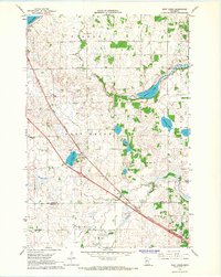 1966 West Union1967 Print · USGSThe West Union area was a patchwork of prairie lakes and rail-side settlements in the mid-sixties. Genealogists and local historians can trace rural school districts like School No 2331 and quiet landmarks such as Elim Ch or Silver Creek Cem.
 - 1966 Map of Osakis, 1967 Print
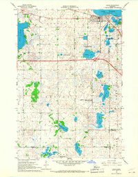 1966 Osakis1967 Print · USGSThe lakeside community of Osakis thrived as a transportation and recreation hub in the mid-sixties. Researchers can trace the town's layout near Lake Osakis, locating St Agnes Sch, the Great Northern rail line, and numerous rural burial grounds like English Grove Cem.2 unique versions available
 - 1966 Map of Lake Osakis East, 1967 Print
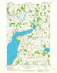 1966 Lake Osakis East1967 Print · USGSCentral Minnesota's lake country is captured here in the mid-sixties, showing the rural townships of Todd County during a period of steady agricultural life. Genealogists can locate family landmarks such as Stallcop Cem, School No 2347, and the Leslie Ch nestled between Lake Osakis and Maple Lake.
End of results
Showing maps 1-3 of 3
Top cities near Osakis
- Alexandria historical maps
- Sauk Centre historical maps
- Glenwood historical maps
- Little Sauk historical maps
- Belle River historical maps
- Carlos historical maps
See more
Frequently asked questions
- What are the different types of historical maps available for Osakis?
- What is the oldest map of Osakis?
- Where can I purchase historical maps of Osakis for my home or office?
- Where can I download high-res historical maps of Osakis?
- Are there historical topographic maps available for Osakis?
- Is there historical aerial imagery available for Osakis?
- Where are historical maps of Osakis sourced from?