1910s Maps of Itasca County, Minnesota
Explore 8 historic maps of Itasca County from the 1910s. These maps offer a rare glimpse into what life looked like during the 1910s — showing old roads, neighborhoods, homes, and landmarks that have changed or disappeared over time.
Whether you're researching your family's past, planning a metal detecting trip, or studying how Itasca County's landscape evolved across the 1910s, these high-resolution maps are a powerful tool for exploring the history of this region.
- Focus on a specific era: All maps on this page are from the 1910s, giving you a focused view of this time period.
- See what’s changed: Compare century-old streets, trails, and buildings to today's modern landscape using overlays and satellite layers.
- Research with precision: Use these maps for genealogy, historical research, land use analysis, or educational projects.
- View, download, or print: Maps are fully viewable online in high resolution, and can be downloaded or printed for your own records.
Start exploring Itasca County's history through authentic maps from the 1910s. This is your window into the past.
Itasca County, MN maps
(8)- 1918 Map of Zora, 1943 Print
 1918 Zora1943 Print · USGSNorthern Minnesota's riverfront and wetlands are documented here in the early twentieth century as drainage projects began to reshape the woods. Researchers can trace the winding Big Fork River and locate early landmarks like Caldwell and the Judicial Ditch.
 - 1919 Map of Rosy
 1919 Rosy1919 Print · USGSNorthern Minnesota during the Great War era reveals a landscape of expanding infrastructure and reservation boundaries. Genealogists and researchers can trace local school locations and early settlements like Alvwood, Rosy, and Louis near the Third River.2 unique versions available
 - 1919 Map of Zora
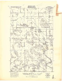
 1919 Zora1919 Print · USGSNorthern Minnesota during the early years of the twentieth century was a landscape of remote timberlands and new county lines. Genealogists and local historians can trace the small settlement of Caldwell and early infrastructure like Judicial Ditch and the Big Fork River.
 - 1919 Map of Gemmell
 1919 Gemmell1919 Print · USGSNorthern Minnesota’s timber and rail landscape is caught here just after the Great War. Genealogists and rail historians can trace the Minnesota and International Ry corridor through Gemmell and Mizpah, or locate the isolated School near Pine Top.
 - 1919 Map of Max
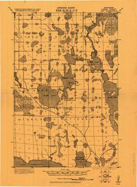 1919 Max1919 Print · USGSItasca County's wooded lake country is captured here during the early days of the Minnesota National Forest. Genealogists and researchers can trace early settlements at Max and Popple or locate remote rural schools near Squaw Lake.2 unique versions available
 - 1919 Map of Release
 1919 Release1919 Print · USGSItasca County during the late teens is revealed here as a remote wilderness of interconnected waterways and nascent settlements. Genealogists and historians can trace the early community around the Release School or explore the shores of Balsam Lake and the Prairie River.
 - 1919 Map of Bridgie, 1924 Print
 1919 Bridgie1924 Print · USGSNorthern Minnesota timber country comes alive in this post-World War I era survey of the borderlands between Beltrami and Koochiching counties. Genealogists and historians can trace the early railroad boom through Northome, Funkley, and Orth along the Minnesota International line.
 - 1919 Map of Marcell, 1943 Print
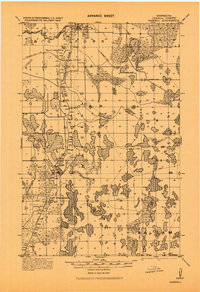 1919 Marcell1943 Print · USGSItasca County in the early twentieth century was defined by a dense network of logging railroads and remote water-bound settlements. You can trace the path of the Minneapolis and Rainy River Railroad through Round Lake Junction, locate the school near Rainy Lake, and explore the layout of Marcell.
End of results
Showing maps 1-8 of 8
Top cities of Itasca County
- Grand Rapids historical maps
- Cohasset historical maps
- Keewatin historical maps
- Coleraine historical maps
- Deer River historical maps
- Nashwauk historical maps
See more
Frequently asked questions
- What are the different types of historical maps available for Itasca County?
- What is the oldest map of Itasca County?
- Where can I purchase historical maps of Itasca County for my home or office?
- Where can I download high-res historical maps of Itasca County?
- Are there historical topographic maps available for Itasca County?
- Is there historical aerial imagery available for Itasca County?
- Where are historical maps of Itasca County sourced from?