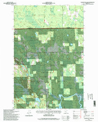
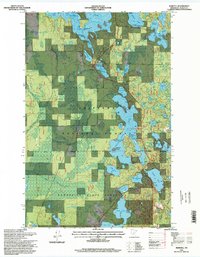
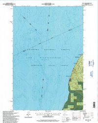
1990s Maps of Itasca County, Minnesota
Explore 38 historic maps of Itasca County from the 1990s. These maps offer a rare glimpse into what life looked like during the 1990s — showing old roads, neighborhoods, homes, and landmarks that have changed or disappeared over time.
Whether you're researching your family's past, planning a metal detecting trip, or studying how Itasca County's landscape evolved across the 1990s, these high-resolution maps are a powerful tool for exploring the history of this region.
- Focus on a specific era: All maps on this page are from the 1990s, giving you a focused view of this time period.
- See what’s changed: Compare century-old streets, trails, and buildings to today's modern landscape using overlays and satellite layers.
- Research with precision: Use these maps for genealogy, historical research, land use analysis, or educational projects.
- View, download, or print: Maps are fully viewable online in high resolution, and can be downloaded or printed for your own records.
Start exploring Itasca County's history through authentic maps from the 1990s. This is your window into the past.
Itasca County, MN maps
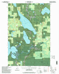
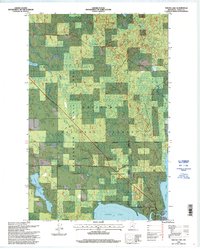
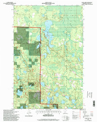
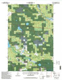
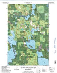
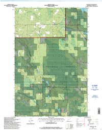
(38)- 1992 Map of Pokegama Lake
 1992 Pokegama Lake1992 Print · USGSItasca County in the early nineties showcases the industrial pulse of the Iron Range and the vast waters of the north woods. Trace the rail lines of the Duluth Missabe and Iron Range Railway or locate old settlements like Wawina and Calumet.
 - 1996 Map of Jessie Lake, 1998 Print
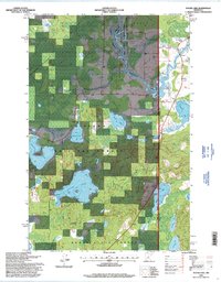
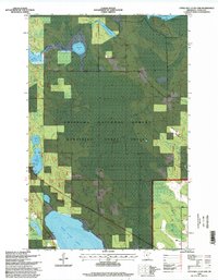
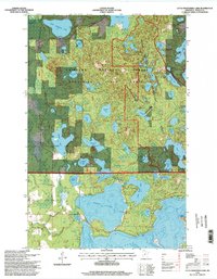
 1996 Jessie Lake1998 Print · USGSItasca County in the late twentieth century is defined by its deep woods and expansive glacial waters. Genealogists and local historians can trace the lakeside communities of Talmoon and Mack, locate old burial sites like Greenwood Cemetery, and explore the northern reaches of the Bowstring Indian Reservation.
 - 1996 Map of Gimmer Lake, 1998 Print
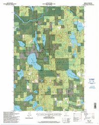
 1996 Gimmer Lake1998 Print · USGSThe lake-strewn border of Beltrami and Itasca counties is shown here in the 1990s, where national and state forests overlap with reservation lands. Researchers can locate the Kitchi Pines Church, an old Cemetery, and the State Waterfowl Refuge near Gimmer Lake.
 - 1996 Map of Coddington Lake, 1998 Print
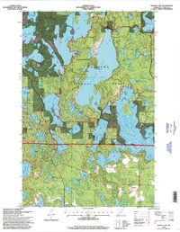
 1996 Coddington Lake1998 Print · USGSItasca and Koochiching counties meet in this 1990s wilderness survey dominated by the Big Fork River and its surrounding wetlands. Local historians can locate the Grafton Cemetery and trace the complex boundaries of the Chippewa National Forest.
 - 1996 Map of Marcell, 1998 Print
 1996 Marcell1998 Print · USGSItasca County's glacial lakes and timber country are shown here in the mid-nineties, centering on the forest community of Marcell. You can trace the local economy and recreation at the Sawmill, the Marcell Ranger Station and Historic Site, and Trestle Landing Boat Ramp.
 - 1996 Map of Bena NW, 1998 Print
 1996 Bena NW1998 Print · USGSLake Winnibigoshish and the surrounding northern Minnesota forests are captured here in the mid-1990s. Researchers can locate recreation-specific landmarks like Birches, the National Forest Permitted Resort, and several Boat Ramp sites.
 - 1996 Map of Squaw Lake, 1998 Print
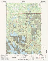
 1996 Squaw Lake1998 Print · USGSNorthern Minnesota forest lands meet the Leech Lake Indian Reservation in the mid-nineties. Trace small settlements like Squaw Lake and Dunbar, or follow the Popple River through the Chippewa National Forest.
 - 1996 Map of Deer River, 1998 Print
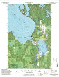
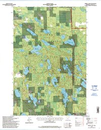
 1996 Deer River1998 Print · USGSThe Mississippi River and White Oak Lake define the Itasca County landscape in the 1990s. Researchers can locate Olivet Cemetery, King School, and the community of Zemple among the forest and wetlands.
 - 1996 Map of Raven Lake, 1998 Print
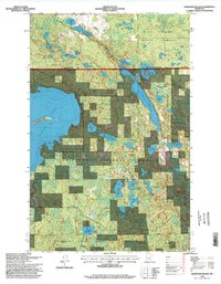
 1996 Raven Lake1998 Print · USGSIn the mid-1990s, the lake-studded forests of Itasca and Cass Counties remained a critical junction for the upper Mississippi and local recreation. Researchers can locate seasonal homes at National Forest Permitted Recreational Residences or trace the shoreline from Ravens Point to Sugar Island.
 - 1996 Map of Balsam Lake, 1998 Print
 1996 Balsam Lake1998 Print · USGSItasca County’s timberlands and glacial lakes are shown here in the late nineties, documenting a landscape dedicated to forest research and recreation. Genealogists and historians can locate the Balsam Chapel and Balsam Cemetery or trace the boundaries of the Marcell Experimental Forest.
 - 1996 Map of Coon Lake, 1998 Print
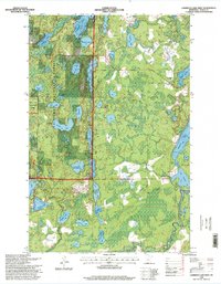
 1996 Coon Lake1998 Print · USGSItasca County’s northern lake country is shown here in the mid-1990s as a intersection of state and federal forest lands. Outdoor historians and researchers can trace trails through Scenic State Park or locate landmarks like the Scenic Lookout and Horton Lake.
 - 1996 Map of Sugar Lake, 1998 Print
 1996 Sugar Lake1998 Print · USGSThe Mississippi River corridor near the Cass and Itasca county line is captured here in the mid-1990s as a hub of conservation and timberland. Outdoor historians and genealogists can locate the West Cohasset Chapel, trace the Sugar Lake Trail System, or explore the bounds of Schoolcraft State Park.
 - 1996 Map of Wirt, 1998 Print
 1996 Wirt1998 Print · USGSNorthern Itasca County was a landscape of dense forests and managed waterways in the mid-nineties. Researchers can locate the settlement of Wirt near the Big Fork River and trace local genealogy at Wirt Cemetery or Sand Lake Cemetery.
 - 1996 Map of Wabana Lake, 1998 Print
 1996 Wabana Lake1998 Print · USGSItasca County’s lake country is mapped in the mid-nineties, showing the intersection of timber management and recreation. Researchers can trace the layout of the Joyce Estate Historic Site and navigate the trails of the Suomi Hills Recreation Area.
 - 1996 Map of Nushka Lake, 1998 Print
 1996 Nushka Lake1998 Print · USGSThe Mississippi headwaters region in the mid-1990s is captured here, showing the intersection of tribal, state, and federal lands. Researchers can trace forest management and water control projects like Bear Brook Impoundment and Sixmile Lake.
 - 1996 Map of Little Winnibigoshish Lake, 1998 Print
 1996 Little Winnibigoshish Lake1998 Print · USGSItasca County in the late nineties is documented here as a landscape of interconnected waterways and protected forest. Researchers can locate the Winnie Dam, a local Cemetery, and specific lakeside features like Sugarbush Point or the Fish Hatchery.2 unique versions available
 - 1996 Map of Bigfork, 1998 Print
 1996 Bigfork1998 Print · USGSBigfork and the surrounding Itasca County wilderness are captured in the mid-1990s as the regional timber and recreational economy thrived. Genealogists and local historians can trace the riverside village near Lakeview Cemetery or explore the woods via the Jingo Lake Trails and Snowmobile Trail.
 - 1996 Map of Lawrence Lake West, 1998 Print
 1996 Lawrence Lake West1998 Print · USGSItasca County’s lake country is captured here in the late twentieth century, showing a landscape defined by timber management and recreation. Genealogists and local historians can locate the Lawron Chapel and trace the paths of the Taconite Trail and Skee-Di-Lakes Trail System.
 - 1996 Map of Dora Lake, 1998 Print
 1996 Dora Lake1998 Print · USGSNorthwoods Minnesota in the late nineties is defined by the dense wetlands of the Chippewa National Forest and the Leech Lake Indian Reservation. Researchers can trace the rural communities of Dora Lake and Oslund, locate the Pine Grove Cemetery, and follow the path of the Big Fork River.
 - 1996 Map of Little Ball Club Lake, 1998 Print
 1996 Little Ball Club Lake1998 Print · USGSItasca County's wooded lake country is captured here during the 1990s, showing a landscape defined by federal and state forest management. You can trace the complex wetlands of the Egg Lake Impoundment and locate local landmarks such as Union Chapel and Tuttle Lake.
 - 1996 Map of Spring Lake, 1998 Print
 1996 Spring Lake1998 Print · USGSThe deep woods of Itasca County come into focus during the late twentieth century, showing a landscape of managed forests and glacial lakes. Researchers can trace the development of timber and water management through sites like Trestle Lake, Riverside Chapel, and the Spur Lake Impoundment.
 - 1996 Map of Elmwood Island, 1998 Print
 1996 Elmwood Island1998 Print · USGSItasca and Koochiching counties meet in this dense forest and wetland landscape during the mid-1990s. Genealogists and outdoorsmen can trace the remote waterways of Moose Lake or locate family landmarks like Elmwood Island and Tuefer Lake.
 - 1996 Map of Alvwood, 1998 Print
 1996 Alvwood1998 Print · USGSItasca County’s northern woods and wetlands are captured in the late nineties, showing a landscape defined by forest management and tribal lands. Genealogists and local historians can trace family sites at Rosy, Alvwood, or the Township Cemetery.
 - 1996 Map of Little Bowstring Lake, 1998 Print
 1996 Little Bowstring Lake1998 Print · USGSItasca County’s timber and lake country is captured here during the mid-nineties, showing a landscape defined by state and national forests. Genealogists and local historians can locate the Suomi Church near the settlement of Suomi or trace the early paths around Deer Lake and Clara Church.
 - 1996 Map of Pennington, 1998 Print
 1996 Pennington1998 Print · USGSPennington and the surrounding lake country appear in the mid-nineties as a hub for forestry and northern recreation. Researchers can trace the winding Mississippi River from Cass Lake past Knutson Dam and explore the Tower Lake Hunter Walker Trails.
Showing maps 1-25 of 38
Top cities of Itasca County
- Grand Rapids historical maps
- Cohasset historical maps
- Keewatin historical maps
- Coleraine historical maps
- Deer River historical maps
- Nashwauk historical maps
See more
Frequently asked questions
- What are the different types of historical maps available for Itasca County?
- What is the oldest map of Itasca County?
- Where can I purchase historical maps of Itasca County for my home or office?
- Where can I download high-res historical maps of Itasca County?
- Are there historical topographic maps available for Itasca County?
- Is there historical aerial imagery available for Itasca County?
- Where are historical maps of Itasca County sourced from?