Old Maps of Itasca County, Minnesota for Genealogy
Trace your family roots with 527 historic maps of Itasca County. These high-res maps reveal old neighborhoods, homesites, landmarks, and streets — helping you uncover where your ancestors lived and how the area evolved over time.
- Explore historic neighborhoods: Identify where your relatives may have lived in the 1800s or 1900s.
- Compare maps over time: Trace the changes in streets, buildings, and landmarks for multi-generational research.
- Perfect for genealogy & ancestry research: Used by family historians and researchers to map out lineage and migration.
These maps are an incredible resource for exploring your personal connection to Itasca County's past.
Itasca County, MN maps
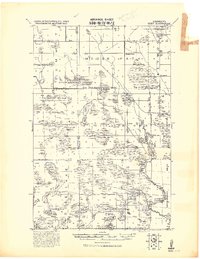
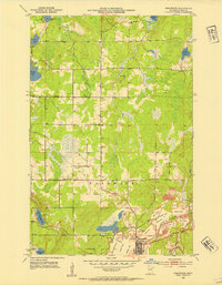
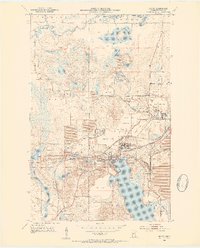
(527)- 1918 Map of Zora, 1943 Print
 1918 Zora1943 Print · USGSNorthern Minnesota's riverfront and wetlands are documented here in the early twentieth century as drainage projects began to reshape the woods. Researchers can trace the winding Big Fork River and locate early landmarks like Caldwell and the Judicial Ditch.
 - 1919 Map of Rosy
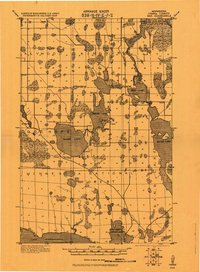
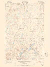
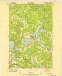
 1919 Rosy1919 Print · USGSNorthern Minnesota during the Great War era reveals a landscape of expanding infrastructure and reservation boundaries. Genealogists and researchers can trace local school locations and early settlements like Alvwood, Rosy, and Louis near the Third River.2 unique versions available
 - 1919 Map of Zora
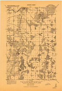
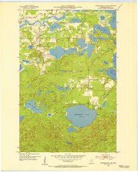
 1919 Zora1919 Print · USGSNorthern Minnesota during the early years of the twentieth century was a landscape of remote timberlands and new county lines. Genealogists and local historians can trace the small settlement of Caldwell and early infrastructure like Judicial Ditch and the Big Fork River.
 - 1919 Map of Gemmell
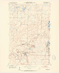
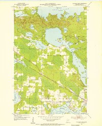
 1919 Gemmell1919 Print · USGSNorthern Minnesota’s timber and rail landscape is caught here just after the Great War. Genealogists and rail historians can trace the Minnesota and International Ry corridor through Gemmell and Mizpah, or locate the isolated School near Pine Top.
 - 1919 Map of Max
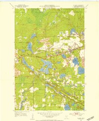
 1919 Max1919 Print · USGSItasca County's wooded lake country is captured here during the early days of the Minnesota National Forest. Genealogists and researchers can trace early settlements at Max and Popple or locate remote rural schools near Squaw Lake.2 unique versions available
 - 1919 Map of Release
 1919 Release1919 Print · USGSItasca County during the late teens is revealed here as a remote wilderness of interconnected waterways and nascent settlements. Genealogists and historians can trace the early community around the Release School or explore the shores of Balsam Lake and the Prairie River.
 - 1919 Map of Bridgie, 1924 Print
 1919 Bridgie1924 Print · USGSNorthern Minnesota timber country comes alive in this post-World War I era survey of the borderlands between Beltrami and Koochiching counties. Genealogists and historians can trace the early railroad boom through Northome, Funkley, and Orth along the Minnesota International line.
 - 1919 Map of Marcell, 1943 Print
 1919 Marcell1943 Print · USGSItasca County in the early twentieth century was defined by a dense network of logging railroads and remote water-bound settlements. You can trace the path of the Minneapolis and Rainy River Railroad through Round Lake Junction, locate the school near Rainy Lake, and explore the layout of Marcell.
 - 1920 Map of Trout Lake
 1920 Trout Lake1920 Print · USGSItasca County's industrial heartland is documented here just as the mining boom transformed the landscape. Trace the early streets and rail spurs of Coleraine, Bovey, and Taconite, or locate lost sites like the U.S.B.M. Dam and Arcturus.
 - 1924 Map of Bridgie, 1944 Print
 1924 Bridgie1944 Print · USGSNorthern Minnesota's woods and wetlands are captured here in the mid-1920s as the rail lines and early settlements began to formalize the landscape. Researchers can trace the path of the Minnesota International through vanished rail stops and small towns like Orth, Funkley, and Bridgie.
 - 1943 Map of Release
 1943 Release1943 Print · USGSItasca County’s lake country is documented here during the early 1940s, based on earlier surveys of this wetland-rich northern terrain. Researchers can locate the Release School and trace the paths around Balsam Lake, Long Lake, and Bear Lake.
 - 1952 Map of Keewatin, 1954 Print
 1952 Keewatin1954 Print · USGSThe Iron Range pulses with industrial activity in the early fifties, centered on the mining hubs of Keewatin and Kelly Lake. Genealogists and industrial historians can trace the massive pits of the Stevenson Mine and Bennett Mine, alongside the complex rail networks of the Great Northern and Mesabi Chief Mine RR.4 unique versions available
 - 1952 Map of Nashwauk, 1954 Print
 1952 Nashwauk1954 Print · USGSNashwauk and the Mesabi Iron Range are shown at a peak of industrial activity in the early fifties. Genealogists and industrial historians can trace the intricate network of the Great Northern railroad connecting the Larue Mine, Cloverdale Sch, and Cooley.3 unique versions available
 - 1952 Map of Silica, 1954 Print
 1952 Silica1954 Print · USGSThe Mesabi Range borderlands in the early fifties show a landscape transition from industrial rail corridors to managed timberlands. Researchers can trace the legacy of the Duluth Missabe and Iron Range tracks, locate St Theresa Ch in Silica, and explore the wetlands around Sand Lake.4 unique versions available
 - 1952 Map of Calumet, 1954 Print
 1952 Calumet1954 Print · USGSThe Mesabi Iron Range dominates this mid-century landscape, showing the massive open-pit operations and mining towns of Itasca County at their industrial peak. Researchers can trace the extensive rail networks and dig sites like the Hill Annex Mine, Majorca Mine, and the settlement of Silverwood.2 unique versions available
 - 1952 Map of Pengilly, 1954 Print
 1952 Pengilly1954 Print · USGSMid-century Itasca County is shaped here by the heavy industry of the Mesabi Range and the sprawling waters of Swan Lake. Genealogists and historians can trace the early layout of Nashwauk or locate specific operations like the Halobe Mine and Kevin Mine.4 unique versions available
 - 1952 Map of Bovey, 1954 Print
 1952 Bovey1954 Print · USGSThe Mesabi Iron Range is in full production in the 1950s, showing a landscape defined by massive open-pit mines and rail spurs. Genealogists and industrial historians can trace the foundations of Coleraine and Bovey alongside active sites like the Canisteo Mine and Lakeview Cem.4 unique versions available
 - 1953 Map of Cohasset East, 1955 Print
 1953 Cohasset East1955 Print · USGSItasca County’s Iron Range comes into focus during the early fifties, showing the interplay of rail and water around the settlement of Cohasset. Genealogists and historians can locate Old Soldiers Cem, the Great Northern rail line, and the industrial footprint of Greenway Mine.3 unique versions available
 - 1953 Map of Siseebakwet Lake, 1955 Print
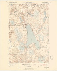
 1953 Siseebakwet Lake1955 Print · USGSItasca County's lake-strewn landscape is captured here in the early fifties, featuring the sprawling waters of Siseebakwet Lake and the Mississippi River. Local historians can trace early aviation and community sites like the Otis Lodge Landing Field and the Community Hall.3 unique versions available
 - 1953 Map of Cohasset West, 1955 Print
 1953 Cohasset West1955 Print · USGSItasca County’s lake country is captured here during the mid-twentieth century, showing the intersection of tribal lands and industrial rail expansion. Researchers can trace the Great Northern line into Cohasset or explore the intricate shorelines of Deer Lake and the Mississippi River.3 unique versions available
 - 1953 Map of Grand Rapids, 1955 Print
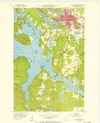 1953 Grand Rapids1955 Print · USGSGrand Rapids and the surrounding lake country are shown here in the early fifties during a period of steady growth. Researchers can find neighborhood schools like Murphy Sch, local landmarks such as the Courthouse, and the intricate shoreline of Pokegama Lake.4 unique versions available
 - 1954 Map of Bemidji, 1966 Print
 1954 Bemidji1966 Print · USGSNorthern Minnesota's lake country and timberlands are captured here at a mid-century peak of rail and road expansion. Genealogists and historians can trace family roots through numerous small settlements like Mahnomen, Clearbrook, and Walker, while locating local landmarks such as White Earth Church.4 unique versions available
 - 1954 Map of Hibbing, 1966 Print
 1954 Hibbing1966 Print · USGSNorthern Minnesota's Iron Range thrives during the mid-1960s, showing the industrial landscape between the Mesabi Range and the Mississippi River. Genealogists and historians can trace the rail lines of the Great Northern RR through mining hubs like Hibbing and Virginia.3 unique versions available
 - 1957 Map of Bemidji
 1957 Bemidji1957 Print · USGSNorthern Minnesota in the mid-fifties is defined by its massive lake systems and the sprawling timberlands of the Chippewa National Forest. Genealogists and researchers can trace old rail lines like the Great Northern RR and locate settlements such as Moberg, Naytahwaush, and Lake Itasca.
 - 1957 Map of Hibbing
 1957 Hibbing1957 Print · USGSNorthern Minnesota's Iron Range is shown at its industrial peak in the mid-fifties, dominated by the massive iron pits and rail corridors of the Mesabi Range. Researchers can trace the rail networks of the Duluth Missabe and Iron Range and locate mining hubs like Hibbing, Virginia, and Bovey.
Showing maps 1-25 of 527
Top cities of Itasca County
- Grand Rapids historical maps
- Cohasset historical maps
- Keewatin historical maps
- Coleraine historical maps
- Deer River historical maps
- Nashwauk historical maps
See more
Frequently asked questions
- What are the different types of historical maps available for Itasca County?
- What is the oldest map of Itasca County?
- Where can I purchase historical maps of Itasca County for my home or office?
- Where can I download high-res historical maps of Itasca County?
- Are there historical topographic maps available for Itasca County?
- Is there historical aerial imagery available for Itasca County?
- Where are historical maps of Itasca County sourced from?