1960s Maps of Saint Louis County, Minnesota
Explore 77 historic maps of Saint Louis County from the 1960s. These maps offer a rare glimpse into what life looked like during the 1960s — showing old roads, neighborhoods, homes, and landmarks that have changed or disappeared over time.
Whether you're researching your family's past, planning a metal detecting trip, or studying how Saint Louis County's landscape evolved across the 1960s, these high-resolution maps are a powerful tool for exploring the history of this region.
- Focus on a specific era: All maps on this page are from the 1960s, giving you a focused view of this time period.
- See what’s changed: Compare century-old streets, trails, and buildings to today's modern landscape using overlays and satellite layers.
- Research with precision: Use these maps for genealogy, historical research, land use analysis, or educational projects.
- View, download, or print: Maps are fully viewable online in high resolution, and can be downloaded or printed for your own records.
Start exploring Saint Louis County's history through authentic maps from the 1960s. This is your window into the past.
Saint Louis County, MN maps
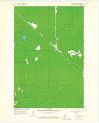
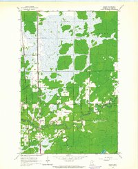
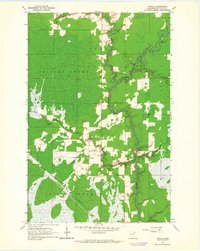
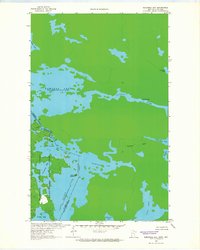
(77)- 1962 Map of Babbitt, 1963 Print
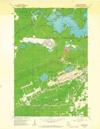 1962 Babbitt1963 Print · USGSBabbitt emerged as a hub for taconite mining in the early sixties, surrounded by the deep woods of the Iron Range. Genealogists and historians can trace the town's grid near High Sch or explore the massive Open Pit Mines and the Reserve Mining Company Railroad.3 unique versions available
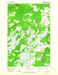
 - 1962 Map of Aurora, 1964 Print
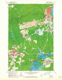 1962 Aurora1964 Print · USGSIron Range industry reaches its mid-century peak in this survey of the northern Mesabi mining district. Researchers can trace the massive Erie Mine No 1 Pit, the rail lines of the Duluth Missabe and Iron Range, and landmarks like Forest Hill Cemetery.4 unique versions available
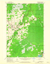
 - 1962 Map of Allen, 1964 Print
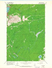 1962 Allen1964 Print · USGSThe Mesabi Range industrial landscape is on full display here in the early 1960s, where heavy iron mining meets the deep woods. Researchers can trace the massive Erie Mine No 2 Pit and the rail corridors of the Duluth Missabe and Iron Range near Allen (Allen Junc Sta).4 unique versions available
 - 1963 Map of Coleman Island, 1964 Print
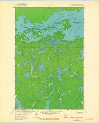
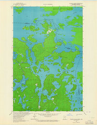 1963 Coleman Island1964 Print · USGSThe Minnesota-Ontario borderlands appear in great detail during the early sixties, showing the complex island-filled waters of Lac La Croix. Researchers can trace old wilderness routes through Fish Stake Narrows and around Coleman Island.2 unique versions available
 - 1963 Map of Gowan, 1964 Print
 1963 Gowan1964 Print · USGSNorthern Minnesota timberland and river valleys are captured here in the early sixties, showing the vital link between water and rail. Researchers can locate the small stations of Gowan and Paupores along the Great Northern railroad line.3 unique versions available
 - 1963 Map of Echo Lake, 1964 Print
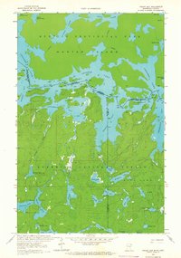
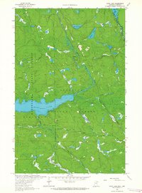 1963 Echo Lake1964 Print · USGSThe Minnesota-Ontario borderlands are captured here in the early sixties, showing a wilderness of water and timber within the Superior National Forest. Trace the primitive Echo Trail past Echo Lake and discover several Gravel Pits and remote waters like Knute Lake.3 unique versions available
 - 1963 Map of Prairie Lake, 1964 Print
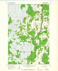
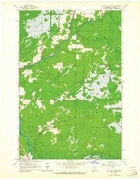
 1963 Prairie Lake1964 Print · USGSNorthern Minnesota lake country is captured here in the early sixties, showing the rural townships of Halden and Floodwood. Genealogists and local historians can trace family-named sites like Moberg Lake, find the old Townhall, and locate both the Prairie Lake Cem and Fine Lake Cem.
 - 1963 Map of Elmer, 1964 Print
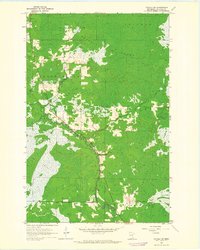
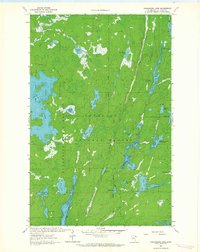
 1963 Elmer1964 Print · USGSSt. Louis County is defined by its massive wetlands and river junctions in the early sixties. Genealogists and local historians can trace the community of Elmer and find landmarks like St Joseph Ch, Rose Hill Cem, and the old rail lines.
 - 1963 Map of Toivola SW, 1964 Print
 1963 Toivola SW1964 Print · USGSSt. Louis County in the early sixties reveals a landscape defined by the winding Floodwood River and vast northern wetlands. Researchers can trace land boundaries and drainage patterns across Toivola Swamp or locate the Roadside Park along the river.2 unique versions available
 - 1963 Map of Upstead Lake, 1964 Print
 1963 Upstead Lake1964 Print · USGSSaint Louis County's wetlands and rail corridors are captured here in the early sixties, highlighting the industrial footprint in the Northwoods. Genealogists and rail historians can trace the Duluth Missabe and Iron Range through Hull and Toivola Station.
 - 1963 Map of Meadowlands NW, 1964 Print
 1963 Meadowlands NW1964 Print · USGSSt. Louis County in the early sixties reveals a landscape of winding rivers and township boundaries in northern Minnesota. Local historians can trace the paths of the St Louis River and Whiteface River, alongside landmarks like the Great Northern and rural Gravel Pits.
 - 1963 Map of Fourtown Lake, 1964 Print
 1963 Fourtown Lake1964 Print · USGSThe Boundary Waters wilderness of the early sixties is preserved here, showing a landscape defined by water and primitive trails. You can trace historic canoe routes through Fourtown Lake, Tin Can Mike Lake, and along the Range River to Jackfish Bay.4 unique versions available
 - 1963 Map of Meadowlands, 1964 Print
 1963 Meadowlands1964 Print · USGSMeadowlands and the surrounding St. Louis County townships are shown in the early sixties as the regional rail and river networks shaped the landscape. Genealogists and locals can trace family landmarks like the Meadowlands Cem, the Witti Memorial Airport, and the winding Whiteface River.3 unique versions available
 - 1963 Map of Kelsey, 1964 Print
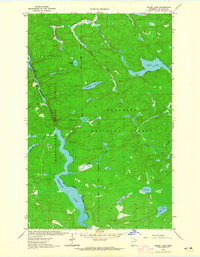
 1963 Kelsey1964 Print · USGSSt. Louis County is mapped in the early 1960s as a landscape shaped by the Iron Range rail lines and the winding Whiteface River. Local historians can locate the Riverside Cem, the settlement of Kelsey, and the Cotton Lookout Tower.2 unique versions available
 - 1963 Map of Takucmich Lake, 1964 Print
 1963 Takucmich Lake1964 Print · USGSThe Minnesota-Ontario borderlands are shown in the early 1960s, a time when this wilderness was defined by its interconnected lakes and rivers. Genealogists and historians can locate established campsites and portage trails near Lac La Croix, Takucmich Lake, and Beartrack Lake.2 unique versions available
 - 1963 Map of Mc Carty River, 1964 Print
 1963 Mc Carty River1964 Print · USGSSt. Louis County in the early sixties is a landscape of river confluences and sprawling wetlands at the edge of the Iron Range. Genealogists and historians can trace the paths of the St Louis River and Great Northern railroad near Van Buren.2 unique versions available
 - 1963 Map of Angleworm Lake, 1964 Print
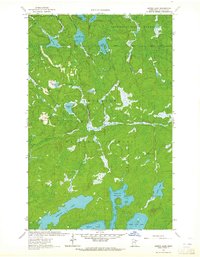
 1963 Angleworm Lake1964 Print · USGSThe northern Minnesota wilderness is captured here in the early 1960s, showing a landscape shaped by glacial lakes and early forest management. Trace the historic Echo Trail and find landmarks like the Angleworm Lookout Tower and Pictured Rock.2 unique versions available
 - 1963 Map of Toivola, 1964 Print
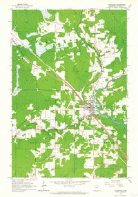
 1963 Toivola1964 Print · USGSNorthern Minnesota’s marshlands and iron ore transport routes are frozen in time during the early sixties. Genealogists and local historians can trace the settlement at Toivola, locate the Sarikoski Cem, and follow the Duluth Missabe and Iron Range railroad.
 - 1963 Map of Floodwood, 1964 Print
 1963 Floodwood1964 Print · USGSFloodwood emerges at the confluence of three rivers during the early sixties, centered on the crossing of the Great Northern railroad. Researchers can locate family sites and rural landmarks like Forest Hill Cem, the Halden Community Center, and Hope Cem.2 unique versions available
 - 1963 Map of Snow Bay, 1964 Print
 1963 Snow Bay1964 Print · USGSThe Boundary Waters wilderness of St. Louis County remains a vast network of interconnected lakes and historic portages in the early sixties. Researchers can trace traditional travel routes like Dawson Portage and Beatty Portage between Loon Lake and Snow Bay.3 unique versions available
 - 1963 Map of Astrid Lake, 1964 Print
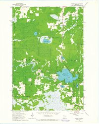
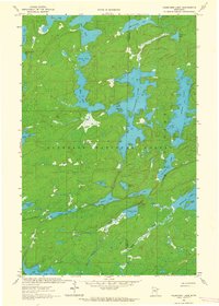
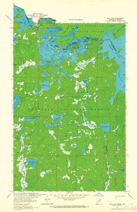
 1963 Astrid Lake1964 Print · USGSNorthern Minnesota's lake-strewn wilderness is captured in the early sixties within the dual boundaries of the state and national forests. Outdoor enthusiasts and researchers can trace the shorelines and depths of Trout Lake, Astrid Lake, and the remote Gowan Lake.3 unique versions available
 - 1963 Map of Redhorse Bay, 1965 Print
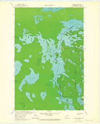
 1963 Redhorse Bay1965 Print · USGSThe Minnesota-Ontario borderlands at the start of the sixties are defined by the winding waterways of the Superior National Forest. Trace the international boundary through Namakan Lake and locate early Campsites near Sand Point.3 unique versions available
 - 1963 Map of Friday Bay, 1965 Print
 1963 Friday Bay1965 Print · USGSThe international borderlands of Minnesota and Ontario were a pristine wilderness in the 1960s. Researchers can trace the ancient canoe routes between Friday Bay and Saturday Bay or locate secluded waters like Ritual Lake and Bear Trap Lake.2 unique versions available
 - 1963 Map of Picket Lake, 1965 Print
 1963 Picket Lake1965 Print · USGSNorthern Minnesota's lake and timber country is captured here in the early sixties, showing the overlap of state and federal forest lands. Researchers can trace the winding Vermilion River and find isolated sites like Picket Lake and the Gravel Pit.2 unique versions available
 - 1963 Map of Iron Lake, 1965 Print
 1963 Iron Lake1965 Print · USGSThe international border between Minnesota and Ontario was a roadless expanse of lakes and portages in the 1960s. Outdoor enthusiasts and researchers can trace ancient canoe routes through Curtain Falls, the islands of Iron Lake, and the remote Nibin Lake.2 unique versions available
Showing maps 1-25 of 77
Top cities of Saint Louis County
- Duluth historical maps
- Hibbing historical maps
- Hermantown historical maps
- Virginia historical maps
- Chisholm historical maps
- Eveleth historical maps
See more
Frequently asked questions
- What are the different types of historical maps available for Saint Louis County?
- What is the oldest map of Saint Louis County?
- Where can I purchase historical maps of Saint Louis County for my home or office?
- Where can I download high-res historical maps of Saint Louis County?
- Are there historical topographic maps available for Saint Louis County?
- Is there historical aerial imagery available for Saint Louis County?
- Where are historical maps of Saint Louis County sourced from?