1980s Maps of Saint Louis County, Minnesota
Explore 10 historic maps of Saint Louis County from the 1980s. These maps offer a rare glimpse into what life looked like during the 1980s — showing old roads, neighborhoods, homes, and landmarks that have changed or disappeared over time.
Whether you're researching your family's past, planning a metal detecting trip, or studying how Saint Louis County's landscape evolved across the 1980s, these high-resolution maps are a powerful tool for exploring the history of this region.
- Focus on a specific era: All maps on this page are from the 1980s, giving you a focused view of this time period.
- See what’s changed: Compare century-old streets, trails, and buildings to today's modern landscape using overlays and satellite layers.
- Research with precision: Use these maps for genealogy, historical research, land use analysis, or educational projects.
- View, download, or print: Maps are fully viewable online in high resolution, and can be downloaded or printed for your own records.
Start exploring Saint Louis County's history through authentic maps from the 1980s. This is your window into the past.
Saint Louis County, MN maps
(10)- 1980 Map of Port Wing
 1980 Port Wing1980 Print · USGSThe Lake Superior shoreline and the deep forests of Bayfield and Douglas counties are captured here in the early eighties. Genealogists and historians can trace the rail lines through Iron River or locate the lakeside landings at Cornucopia and Port Wing.
 - 1980 Map of Duluth
 1980 Duluth1980 Print · USGSThe Twin Ports of the early 1980s showcase a landscape defined by heavy rail lines and Lake Superior shipping. Trace the iron-ore routes through Proctor or locate family sites near Sunrise Memorial Cem and Floodwood.
 - 1981 Map of Skibo, 1982 Print
 1981 Skibo1982 Print · USGSSkibo and the surrounding timberlands are documented here in the late seventies as the rail-and-river economy of the Iron Range persisted. Genealogists and historians can trace the Duluth Missabe and Iron Range tracks past Skibo Mill, Clappers, and Reno.2 unique versions available
 - 1981 Map of Turpela Lake, 1982 Print
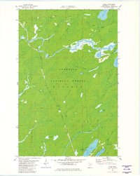
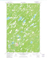
 1981 Turpela Lake1982 Print · USGSIron Range wetlands and the Superior National Forest define this landscape during the early 1980s. Researchers can trace family-named landmarks like Hautala Lake and Kumpula Lake or locate industrial sites like the Gaging Station and various Gravel Pits.2 unique versions available
 - 1981 Map of Bird Lake, 1982 Print
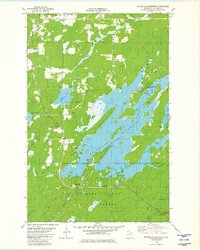
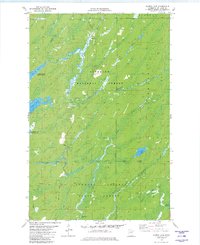
 1981 Bird Lake1982 Print · USGSThe Superior National Forest remains a wild landscape of timber and wetlands in the early 1980s, shaped by the winding St Louis River. Local historians can trace the Duluth Missabe and Iron Range railroad or locate landmarks like Skibo Vista and Hush Lake.2 unique versions available
 - 1981 Map of Whiteface Reservoir, 1982 Print
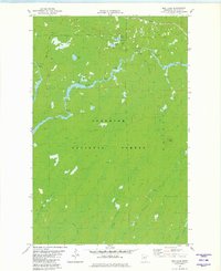
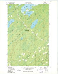
 1981 Whiteface Reservoir1982 Print · USGSSt. Louis County is shown in the early eighties as a hub for northern forestry and recreation. Researchers can trace land use patterns across the Superior National Forest and locate specific sites like the Markham Cem or the Cloquet Valley Lookout Tower.2 unique versions available
 - 1981 Map of Brimson, 1982 Print
 1981 Brimson1982 Print · USGSSt. Louis County is captured here in the early 1980s, where the logging and rail history of northern Minnesota meets the wilderness. Researchers can locate remote burial sites at Brimson Cem, trace the Duluth Missabe and Iron Range tracks, or follow the Old Railroad Grade.2 unique versions available
 - 1981 Map of Harris Lake, 1982 Print
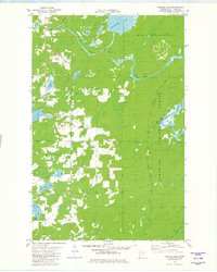
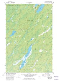
 1981 Harris Lake1982 Print · USGSThe St. Louis County woods were heavily managed for timber and recreation during the early eighties. Researchers can trace seasonal routes like the Snowmobile Trail and Winter Trail near Harris Lake and the Whiteface Reservoir.3 unique versions available
 - 1981 Map of Toimi, 1982 Print
 1981 Toimi1982 Print · USGSThe Iron Range fringes of St. Louis County in the late seventies reveal a landscape defined by timber and transit. Genealogists and historians can trace the community core around Toimi, including the Bassett Cem, the Townhall, and the Seven Beaver Mining Railroad.2 unique versions available
 - 1982 Map of Fairbanks
 1982 Fairbanks1982 Print · USGSSt. Louis County is shown during the early 1980s as a landscape of timber and transit within the Superior National Forest. Researchers can trace the Duluth Missabe and Iron Range Railroad as it passes the small outposts of Fairbanks and Brimson.2 unique versions available
End of results
Showing maps 1-10 of 10
Top cities of Saint Louis County
- Duluth historical maps
- Hibbing historical maps
- Hermantown historical maps
- Virginia historical maps
- Chisholm historical maps
- Eveleth historical maps
See more
Frequently asked questions
- What are the different types of historical maps available for Saint Louis County?
- What is the oldest map of Saint Louis County?
- Where can I purchase historical maps of Saint Louis County for my home or office?
- Where can I download high-res historical maps of Saint Louis County?
- Are there historical topographic maps available for Saint Louis County?
- Is there historical aerial imagery available for Saint Louis County?
- Where are historical maps of Saint Louis County sourced from?