1960s Maps of Amite County, Mississippi
Explore 6 historic maps of Amite County from the 1960s. These maps offer a rare glimpse into what life looked like during the 1960s — showing old roads, neighborhoods, homes, and landmarks that have changed or disappeared over time.
Whether you're researching your family's past, planning a metal detecting trip, or studying how Amite County's landscape evolved across the 1960s, these high-resolution maps are a powerful tool for exploring the history of this region.
- Focus on a specific era: All maps on this page are from the 1960s, giving you a focused view of this time period.
- See what’s changed: Compare century-old streets, trails, and buildings to today's modern landscape using overlays and satellite layers.
- Research with precision: Use these maps for genealogy, historical research, land use analysis, or educational projects.
- View, download, or print: Maps are fully viewable online in high resolution, and can be downloaded or printed for your own records.
Start exploring Amite County's history through authentic maps from the 1960s. This is your window into the past.
Amite County, MS maps
(6)- 1961 Map of Liberty, 1962 Print
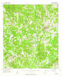 1961 Liberty1962 Print · USGSAmite County in the early sixties reveals a landscape of small river settlements and forest land. Researchers can trace family history through dozens of rural sites like Bewelcome, McGeehee Cem, and Amite River Galilee Ch.3 unique versions available
 - 1961 Map of Crosby, 1962 Print
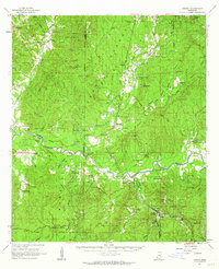 1961 Crosby1962 Print · USGSThe Homochitto River valley and its neighboring oil fields are captured here in the early sixties as they span four Mississippi counties. Researchers can trace rural lineages through numerous family sites like Dorsey Cem, Perrytown Ch, and the Illinois Central Railroad corridor.3 unique versions available
 - 1961 Map of Gloster, 1963 Print
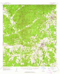 1961 Gloster1963 Print · USGSSouthwest Mississippi is mapped here in the early sixties, showing the rural communities along the Illinois Central line. Genealogists can trace family roots at Wilkinson Cem, Mt Carmel Ch, and the small settlement of Caledonia.2 unique versions available
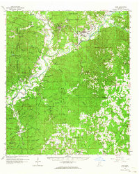
 - 1961 Map of Baton Rouge, 1966 Print
 1961 Baton Rouge1966 Print · USGSSoutheastern Louisiana in the early sixties remains a landscape of deep river bends and sprawling coastal lakes. Genealogists and historians can trace the rail-and-river economy through landmarks like Free-Nigger Point, Donaldsonville, and the Illinois Central Railroad.
 - 1962 Map of Baton Rouge
 1962 Baton Rouge1962 Print · USGSSouth Louisiana in the early sixties reveals a landscape of river-bend parishes and emerging interstate corridors. Genealogists and historians can trace family roots through historic river towns like Donaldsonville and Plaquemine, or follow the path of the Illinois Central Railroad through the swamp basins.
 - 1962 Map of Bude, 1964 Print
 1962 Bude1964 Print · USGSSouthwest Mississippi's timber and oil country comes to life in the early sixties, centered on the lumber and rail hubs of Meadville and Bude. Genealogists can trace family lines through dozen of rural landmarks like Byrds Chapel, Smyrna Cemetery, and the West Bude Oil Field.2 unique versions available
End of results
Showing maps 1-6 of 6
Top cities of Amite County
Frequently asked questions
- What are the different types of historical maps available for Amite County?
- What is the oldest map of Amite County?
- Where can I purchase historical maps of Amite County for my home or office?
- Where can I download high-res historical maps of Amite County?
- Are there historical topographic maps available for Amite County?
- Is there historical aerial imagery available for Amite County?
- Where are historical maps of Amite County sourced from?