1970s Maps of Amite County, Mississippi
Explore 6 historic maps of Amite County from the 1970s. These maps offer a rare glimpse into what life looked like during the 1970s — showing old roads, neighborhoods, homes, and landmarks that have changed or disappeared over time.
Whether you're researching your family's past, planning a metal detecting trip, or studying how Amite County's landscape evolved across the 1970s, these high-resolution maps are a powerful tool for exploring the history of this region.
- Focus on a specific era: All maps on this page are from the 1970s, giving you a focused view of this time period.
- See what’s changed: Compare century-old streets, trails, and buildings to today's modern landscape using overlays and satellite layers.
- Research with precision: Use these maps for genealogy, historical research, land use analysis, or educational projects.
- View, download, or print: Maps are fully viewable online in high resolution, and can be downloaded or printed for your own records.
Start exploring Amite County's history through authentic maps from the 1970s. This is your window into the past.
Amite County, MS maps
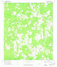
(6)- 1972 Map of Smithdale, 1974 Print
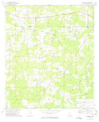 1972 Smithdale1974 Print · USGSAmite County and Franklin County are captured here in the early seventies, a landscape of family farms and rural industry along the Amite River. Researchers can locate several family burial sites like Lumpkin Cem and old country parishes such as Oak Grove Ch.
 - 1972 Map of Auburn, 1974 Print
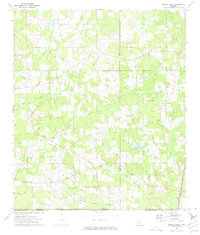
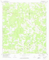 1972 Auburn1974 Print · USGSAmite and Lincoln Counties come into focus in the early seventies as the local oil industry expands across the landscape. Genealogists can trace family roots through numerous country sites like Johnston Chapel, Terrell Cem, and the Smithdale Oil Field.
 - 1972 Map of Peoria, 1974 Print
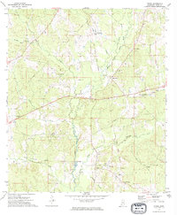 1972 Peoria1974 Print · USGSAmite County's rural river country is captured here in the early 1970s, showcasing a landscape shaped by water and historical lines. You can trace the Old Indian Treaty Boundary and locate family landmarks like Bates-Felder Cem and Browns Chapel.
 - 1972 Map of Lake Tangipahoa, 1974 Print
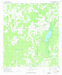 1972 Lake Tangipahoa1974 Print · USGSSouthwest Mississippi during the early seventies is defined here by the waters of Lake Tangipahoa and the busy Mc Comb Oil Field. Genealogists and historians can trace rural family landmarks like Rose Bower Church, Pikemite Cemetery, and the Old Railroad Grade.
 - 1972 Map of Gillsburg, 1975 Print
 1972 Gillsburg1975 Print · USGSAmite County at the start of the 1970s remains a landscape of deep family roots and historic lines, including the Old Indian Treaty Boundary. Genealogists can trace property and family sites at Gillsburg, Huron, and scattered burial grounds like Lea Cem and Wall Cem.2 unique versions available
 - 1972 Map of Terrys Creek, 1975 Print
 1972 Terrys Creek1975 Print · USGSThe Mississippi-Louisiana borderlands in the early seventies reveal a rural landscape defined by the Tickfaw River and local industry. Genealogists and historians can trace the Gillsburg Oil Field, family-named landmarks like Roberts Cem, and the Terrys Creek Ch.
End of results
Showing maps 1-6 of 6
Top cities of Amite County
Frequently asked questions
- What are the different types of historical maps available for Amite County?
- What is the oldest map of Amite County?
- Where can I purchase historical maps of Amite County for my home or office?
- Where can I download high-res historical maps of Amite County?
- Are there historical topographic maps available for Amite County?
- Is there historical aerial imagery available for Amite County?
- Where are historical maps of Amite County sourced from?