1940s Maps of Greene County, Mississippi
Explore 10 historic maps of Greene County from the 1940s. These maps offer a rare glimpse into what life looked like during the 1940s — showing old roads, neighborhoods, homes, and landmarks that have changed or disappeared over time.
Whether you're researching your family's past, planning a metal detecting trip, or studying how Greene County's landscape evolved across the 1940s, these high-resolution maps are a powerful tool for exploring the history of this region.
- Focus on a specific era: All maps on this page are from the 1940s, giving you a focused view of this time period.
- See what’s changed: Compare century-old streets, trails, and buildings to today's modern landscape using overlays and satellite layers.
- Research with precision: Use these maps for genealogy, historical research, land use analysis, or educational projects.
- View, download, or print: Maps are fully viewable online in high resolution, and can be downloaded or printed for your own records.
Start exploring Greene County's history through authentic maps from the 1940s. This is your window into the past.
Greene County, MS maps
(10)- 1941 Map of Lucedale, 1961 Print
 1941 Lucedale1961 Print · USGSGeorge County's timber and rail landscape is meticulously captured here in the early 1940s as the rail lines intersect at Lucedale. Genealogists can trace family roots through numerous sites like Agricola High Sch, Woodard Cem, and the Mengel Lumber Camp.2 unique versions available
 - 1942 Map of Deer Park, 1966 Print
 1942 Deer Park1966 Print · USGSCrossing the state line in the 1940s, this area is defined by the river systems and early rail lines of the Piney Woods. Genealogists can locate family landmarks like Turners Store, Stalworth Camp, and small rural schools including McCann Sch.
 - 1942 Map of Wilmer, 1968 Print
 1942 Wilmer1968 Print · USGSMobile County and the Mississippi borderlands are captured here in the early 1940s, showing a landscape of timber ridges and river bottoms. Family historians can trace rural roots through Moffet Cem, Fellowship Ch, and the settlement at Wilmer.
 - 1943 Map of Lucedale
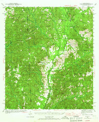
 1943 Lucedale1943 Print · USGSSoutheastern Mississippi at the start of the 1940s reveals a landscape of river confluences and timber-driven rail hubs. Genealogists can trace family landmarks like Ball Cem and Gibson Cem or old schools including Agricola High Sch.2 unique versions available
 - 1943 Map of Deer Park
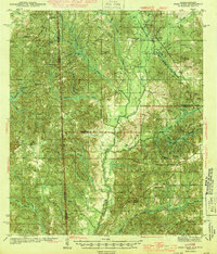 1943 Deer Park1943 Print · USGSSouthwestern Alabama near the Mississippi border is shown here during the early 1940s, centered on the logging and rail corridors of the Escatawpa River. Researchers can locate rural landmarks like Stalworth Camp, the Mississippi and Alabama RR, and several churches including Shiloh Ch.2 unique versions available
 - 1944 Map of Wilmer
 1944 Wilmer1944 Print · USGSMobile County and the Mississippi borderlands are captured here during the early years of the war. Genealogists and local historians can trace family roots through markers like Moffet, Semmes Cem, and the old Howell Sch along the Escatappa River.2 unique versions available
 - 1947 Map of Beaumont, 1963 Print
 1947 Beaumont1963 Print · USGSPerry and Greene Counties are shown in the late 1940s, where the winding Leaf River and timber lands meet the De Soto National Forest. Trace family history through landmarks like McSwain Sch, Lott Cem, and the railroad junctions at Beaumont.2 unique versions available
 - 1947 Map of Benndale, 1966 Print
 1947 Benndale1966 Print · USGSSoutheast Mississippi's piney woods and river bottoms are documented here just after the war. Researchers can locate family landmarks like Alexander Bridge, Indian Cem, and the community of Benndale amidst the Pascagoula River wetlands.2 unique versions available
 - 1949 Map of Beaumont
 1949 Beaumont1949 Print · USGSSoutheastern Mississippi timber and rail networks thrive mid-century at the junction of the Leaf River and Gulf Mobile and Ohio railroad. Researchers can locate the Camp Shelby Military Reservation and historic sites like Avent Station and the Lott Cem.2 unique versions available
 - 1949 Map of Benndale
 1949 Benndale1949 Print · USGSSoutheast Mississippi's piney woods and river bottoms come into focus in the late 1940s as the De Soto National Forest reaches across four counties. Researchers can trace the heritage of local settlements through Benndale, St Luke Ch, and several family cemeteries.2 unique versions available
End of results
Showing maps 1-10 of 10
Top cities of Greene County
Frequently asked questions
- What are the different types of historical maps available for Greene County?
- What is the oldest map of Greene County?
- Where can I purchase historical maps of Greene County for my home or office?
- Where can I download high-res historical maps of Greene County?
- Are there historical topographic maps available for Greene County?
- Is there historical aerial imagery available for Greene County?
- Where are historical maps of Greene County sourced from?