1980s Maps of Greene County, Mississippi
Explore 12 historic maps of Greene County from the 1980s. These maps offer a rare glimpse into what life looked like during the 1980s — showing old roads, neighborhoods, homes, and landmarks that have changed or disappeared over time.
Whether you're researching your family's past, planning a metal detecting trip, or studying how Greene County's landscape evolved across the 1980s, these high-resolution maps are a powerful tool for exploring the history of this region.
- Focus on a specific era: All maps on this page are from the 1980s, giving you a focused view of this time period.
- See what’s changed: Compare century-old streets, trails, and buildings to today's modern landscape using overlays and satellite layers.
- Research with precision: Use these maps for genealogy, historical research, land use analysis, or educational projects.
- View, download, or print: Maps are fully viewable online in high resolution, and can be downloaded or printed for your own records.
Start exploring Greene County's history through authentic maps from the 1980s. This is your window into the past.
Greene County, MS maps
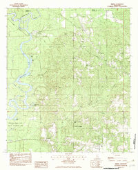
(12)- 1982 Map of Neely
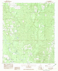 1982 Neely1982 Print · USGSGreene and Perry Counties are shown in the early eighties as the ILLINOIS CENTRAL GULF line moved through the DE SOTO NATIONAL FOREST. Researchers can trace rural lineages at Sylvester Cem or locate community hubs like Buffalo Ch and the settlement of Neely.
 - 1982 Map of Lucedale
 1982 Lucedale1982 Print · USGSGeorge County in the early eighties shows a landscape of timberlands and rural communities centered on the growth of Lucedale. Genealogists and local historians can trace family locations through numerous sites like Magnolia Garden Cem, Rocky Creek Sch, and the Antioch Missionary Ch.
 - 1982 Map of Earlville
 1982 Earlville1982 Print · USGSThe Alabama and Mississippi borderlands come into focus in the early eighties, showcasing a rural landscape defined by the winding Escatawpa River. Genealogists and local historians can trace family roots at Moffet Cem or visit community landmarks like Macedonia Ch and Earlville.3 unique versions available
 - 1982 Map of Brown Town
 1982 Brown Town1982 Print · USGSThe Alabama and Mississippi borderlands are captured here in the early eighties, showcasing a rural landscape of timbered ridges and creek bottoms. Local researchers can locate Mt Pisgah Ch, the Maples Cem, and the small settlements of Brown Town and Pisgah.3 unique versions available
 - 1982 Map of Merrill
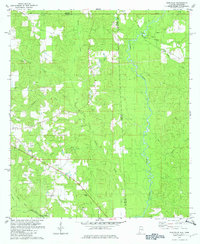
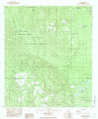
 1982 Merrill1982 Print · USGSNear the confluence of the Leaf and Chickasawhay Rivers in the early 1980s, this area shows a landscape of timberlands and river bottoms. Genealogists can locate family burial sites like Howard Cem and remote landmarks such as Booger Hole Slough.
 - 1982 Map of Rounsaville
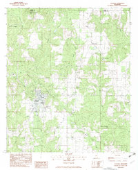
 1982 Rounsaville1982 Print · USGSThe borderlands of Greene County and Washington County come into focus during the late seventies, showing a landscape defined by timber and transit. Genealogists and historians can trace the Old Railroad Grade and locate Rounsaville Ch or Burbank Cem.
 - 1982 Map of Avent
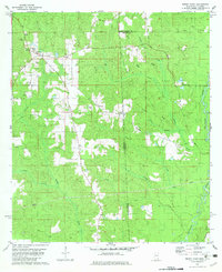
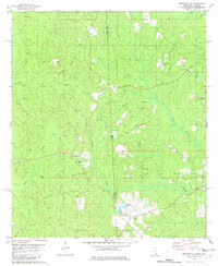
 1982 Avent1982 Print · USGSThe Pascagoula River bottomlands and De Soto National Forest are documented here in the early eighties. Genealogists and historians can trace family locations through Mt Rose Ch, Salem Ch, and the Mixon-Mizelle Cem near the Greene and George county line.
 - 1982 Map of McLain, 1983 Print
 1982 McLain1983 Print · USGSSoutheast Mississippi's river timberlands and rail corridors are captured here in the early eighties. Genealogists and local historians can trace family-named sites like McLain Cem, Mt Nebo Ch, and the winding Hillman Dead River.
 - 1984 Map of Citronelle
 1984 Citronelle1984 Print · USGSThe Alabama-Mississippi borderlands in the mid-1980s were a hub of timber and rail, spanning from the Leaf River to the Mobile County line. Genealogists can trace family roots through rural communities like Sims Chapel, Leakesville, and Vinegar Bend.2 unique versions available
 - 1984 Map of Hattiesburg
 1984 Hattiesburg1984 Print · USGSSouth Mississippi’s Pine Belt is seen here in the mid-eighties, showing the region as a hub of timber production and petroleum extraction. Trace the rail lines of the Illinois Central Gulf RR through old settlements like Richton or the energy developments at the Heidelberg Oil Field.2 unique versions available
 - 1984 Map of Mobile
 1984 Mobile1984 Print · USGSMobile and its surrounding Gulf Coast backcountry appear in the mid-eighties as a hub of maritime industry and timber management. Genealogists and historians can trace the development of the riverfront near McDuffie Island or explore rural settlements like Lucedale and Chunchula.
 - 1984 Map of Mobile
 1984 Mobile1984 Print · USGSThe Gulf Coast at the height of the mid-eighties shows a landscape of rapid industrial growth and military significance. Researchers can trace the sprawling rail lines of the Illinois Central Gulf RR, locate the NASA Test Facility, or study the barrier island chain from Cat Island to Petit Bois Island.3 unique versions available
End of results
Showing maps 1-12 of 12
Top cities of Greene County
Frequently asked questions
- What are the different types of historical maps available for Greene County?
- What is the oldest map of Greene County?
- Where can I purchase historical maps of Greene County for my home or office?
- Where can I download high-res historical maps of Greene County?
- Are there historical topographic maps available for Greene County?
- Is there historical aerial imagery available for Greene County?
- Where are historical maps of Greene County sourced from?