1920s Maps of Iron County, Missouri
Explore 4 historic maps of Iron County from the 1920s. These maps offer a rare glimpse into what life looked like during the 1920s — showing old roads, neighborhoods, homes, and landmarks that have changed or disappeared over time.
Whether you're researching your family's past, planning a metal detecting trip, or studying how Iron County's landscape evolved across the 1920s, these high-resolution maps are a powerful tool for exploring the history of this region.
- Focus on a specific era: All maps on this page are from the 1920s, giving you a focused view of this time period.
- See what’s changed: Compare century-old streets, trails, and buildings to today's modern landscape using overlays and satellite layers.
- Research with precision: Use these maps for genealogy, historical research, land use analysis, or educational projects.
- View, download, or print: Maps are fully viewable online in high resolution, and can be downloaded or printed for your own records.
Start exploring Iron County's history through authentic maps from the 1920s. This is your window into the past.
Iron County, MO maps
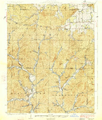
(4)- 1924 Map of Edgehill, 1962 Print
 1924 Edgehill1962 Print · USGSThe Missouri Ozarks are captured here during the mid-1920s, showing a landscape of remote mountain settlements and small valley farms. Local historians can trace early rural life through landmarks like Maxwells Mill, the Mountainville Store, and the Beulah Land Church.
 - 1926 Map of Edgehill
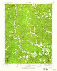
 1926 Edgehill1926 Print · USGSThe Missouri Ozarks are captured here in the mid-1920s, showing a landscape of remote mountain schools and water-driven industry. Local historians can trace the foundations of Edgehill and Monterey, or locate early landmarks like Maxwells Mill and Council Bluff Church.3 unique versions available
 - 1926 Map of Des Arc, 1960 Print
 1926 Des Arc1960 Print · USGSIron and Wayne County hills are captured here in the mid-1920s, showing a landscape defined by the Missouri Pacific rail line. Genealogists can locate family-named landmarks like Emilys Chapel and numerous rural schoolhouses from Glover Sch to Brunot Sch.2 unique versions available
 - 1929 Map of Des Arc
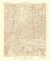 1929 Des Arc1929 Print · USGSIron and Madison counties in the late 1920s show a landscape of mountain hollows and railroad towns. Trace the Missouri Pacific line through Des Arc and Annapolis, or locate ancestral sites like Emily's Chapel and the Jewett Sch.3 unique versions available
End of results
Showing maps 1-4 of 4
Top cities of Iron County
- Ironton historical maps
- Viburnum historical maps
- Pilot Knob historical maps
- Arcadia historical maps
- Annapolis historical maps
- Des Arc historical maps
Frequently asked questions
- What are the different types of historical maps available for Iron County?
- What is the oldest map of Iron County?
- Where can I purchase historical maps of Iron County for my home or office?
- Where can I download high-res historical maps of Iron County?
- Are there historical topographic maps available for Iron County?
- Is there historical aerial imagery available for Iron County?
- Where are historical maps of Iron County sourced from?