2000-2009 Maps of Iron County, Missouri
Explore 5 historic maps of Iron County from 2000-2009. These maps offer a rare glimpse into what life looked like during the 2000s — showing old roads, neighborhoods, homes, and landmarks that have changed or disappeared over time.
Whether you're researching your family's past, planning a metal detecting trip, or studying how Iron County's landscape evolved across the 2000s, these high-resolution maps are a powerful tool for exploring the history of this region.
- Focus on a specific era: All maps on this page are from the 2000s, giving you a focused view of this time period.
- See what’s changed: Compare century-old streets, trails, and buildings to today's modern landscape using overlays and satellite layers.
- Research with precision: Use these maps for genealogy, historical research, land use analysis, or educational projects.
- View, download, or print: Maps are fully viewable online in high resolution, and can be downloaded or printed for your own records.
Start exploring Iron County's history through authentic maps from the 2000s. This is your window into the past.
Iron County, MO maps
(5)- 2000 Map of Glover, 2003 Print
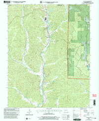 2000 Glover2003 Print · USGSIron County at the start of the new millennium shows a landscape defined by the Missouri Pacific RR corridor and the surrounding national forest. Researchers can trace rural church history at Emmaus Chapel or locate family sites like Huff Cem and the Lead Smelter near Chloride.
 - 2000 Map of Des Arc NE, 2003 Print
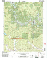 2000 Des Arc NE2003 Print · USGSIron and Madison counties are shown here as the new millennium began, dominated by the heavily timbered tracts of the Mark Twain National Forest. Genealogists and hikers can trace the Ozark Trail past rural landmarks like Liberty United Cem, Minimum, and the remote Black Mtn Ch.
 - 2000 Map of Lake Killarney, 2003 Print
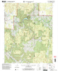 2000 Lake Killarney2003 Print · USGSThe Iron County hill country at the start of the millennium is captured here, showing the gateway to the St. Francois Mountains. Researchers can locate numerous family burial grounds like Royer Cem and Sutton Cem, or trace the development of Killarney Shores and the Arcadia Valley Golf Club.
 - 2000 Map of Iron Mountain Lake, 2003 Print
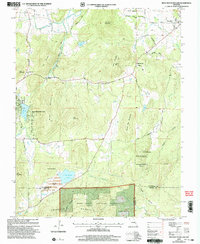 2000 Iron Mountain Lake2003 Print · USGSThe St. Francois Mountains area of Missouri is captured here just as the new millennium began, showing a landscape defined by mining history and timbered heights. Researchers can trace family roots through several rural burial sites like the German Cem and landmarks such as Stone Union Ch or the settlement of Doe Run.
 - 2000 Map of Ironton, 2003 Print
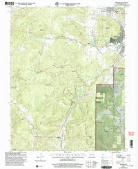 2000 Ironton2003 Print · USGSIron County’s Arcadia Valley is captured at the millennium, showing the established communities of Ironton and Arcadia surrounded by the state's highest peaks. Genealogists and historians can locate the Site of Fort Davidson, Ursuline Academy, and rural landmarks like Victory Ch.
End of results
Showing maps 1-5 of 5
Top cities of Iron County
- Ironton historical maps
- Viburnum historical maps
- Pilot Knob historical maps
- Arcadia historical maps
- Annapolis historical maps
- Des Arc historical maps
Frequently asked questions
- What are the different types of historical maps available for Iron County?
- What is the oldest map of Iron County?
- Where can I purchase historical maps of Iron County for my home or office?
- Where can I download high-res historical maps of Iron County?
- Are there historical topographic maps available for Iron County?
- Is there historical aerial imagery available for Iron County?
- Where are historical maps of Iron County sourced from?