1990s Maps of Iron County, Missouri
Explore 8 historic maps of Iron County from the 1990s. These maps offer a rare glimpse into what life looked like during the 1990s — showing old roads, neighborhoods, homes, and landmarks that have changed or disappeared over time.
Whether you're researching your family's past, planning a metal detecting trip, or studying how Iron County's landscape evolved across the 1990s, these high-resolution maps are a powerful tool for exploring the history of this region.
- Focus on a specific era: All maps on this page are from the 1990s, giving you a focused view of this time period.
- See what’s changed: Compare century-old streets, trails, and buildings to today's modern landscape using overlays and satellite layers.
- Research with precision: Use these maps for genealogy, historical research, land use analysis, or educational projects.
- View, download, or print: Maps are fully viewable online in high resolution, and can be downloaded or printed for your own records.
Start exploring Iron County's history through authentic maps from the 1990s. This is your window into the past.
Iron County, MO maps
(8)- 1999 Map of Edgehill, 2002 Print
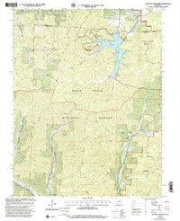
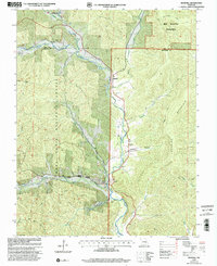 1999 Edgehill2002 Print · USGSThe Reynolds and Iron County line runs through this Ozark highland landscape at the end of the twentieth century. Genealogists and hikers can trace family histories at Black River Cem or explore the heights of Goggins Mountain along the Ozark Trail.
 - 1999 Map of Viburnum West, 2002 Print
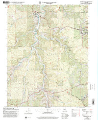 1999 Viburnum West2002 Print · USGSThe Missouri Ozarks are captured here at the close of the millennium, showing a landscape defined by federal forest lands and the lead industry. Researchers can find old family burial grounds like Maple Grove Cem, the site of Richards Charcoal Kilns, and the historic Dillard Mill State Historical Site.
 - 1999 Map of Viburnum East, 2002 Print
 1999 Viburnum East2002 Print · USGSThe Missouri Lead Belt is captured in detail during the late 1990s, showcasing a landscape defined by heavy industry and small Ozark communities. Researchers can trace mining operations at the Magmont Mine or locate rural family landmarks like Abbott Cemetery and West End School.
 - 1999 Map of Johnson Shut-Ins, 2002 Print
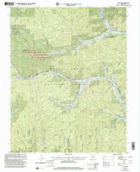
 1999 Johnson Shut-Ins2002 Print · USGSThe St. Francois Mountains in the late nineties are shown here at the intersection of public conservation and industrial energy. Researchers can trace rural roots at Marys Chapel or Hasty Cem, alongside the massive Upper Reservoir and power facilities.
 - 1999 Map of Johnson Mountain, 2002 Print
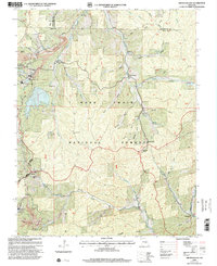
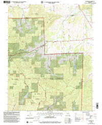
 1999 Johnson Mountain2002 Print · USGSIron County’s highland landscape is shown here at the close of the twentieth century, dominated by forest service lands and new reservoirs. You can trace the footprint of the Enough settlement, locate the Terry Cem, or follow the Ozark Trail through the Bell Mountain Wilderness.
 - 1999 Map of Banner, 2002 Print
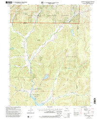
 1999 Banner2002 Print · USGSThe Iron and Washington County line at the close of the century reveals a landscape shaped by forest conservation and rural life. Researchers can trace family history at Tullock Cem or explore the wilderness boundaries near Banner and Pruitt Mountain.
 - 1999 Map of Greeley, 2002 Print
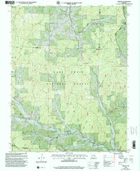 1999 Greeley2002 Print · USGSThe Missouri Ozarks during the late twentieth century reveal a landscape where forestry and heavy industry meet. Genealogists and historians can trace the foundations of Greeley and Crossville or locate remote sites like the Charcoal Kilns and Barton Cem.
 - 1999 Map of Oates, 2002 Print
 1999 Oates2002 Print · USGSReynolds and Iron counties were still heavily forested and punctuated by small mining operations at the end of the century. Genealogists and local historians can trace family roots through numerous burial sites like Smith Cem and Myers Cem, or locate landmarks like Buck Mine and the Happy Home Ch.
End of results
Showing maps 1-8 of 8
Top cities of Iron County
- Ironton historical maps
- Viburnum historical maps
- Pilot Knob historical maps
- Arcadia historical maps
- Annapolis historical maps
- Des Arc historical maps
Frequently asked questions
- What are the different types of historical maps available for Iron County?
- What is the oldest map of Iron County?
- Where can I purchase historical maps of Iron County for my home or office?
- Where can I download high-res historical maps of Iron County?
- Are there historical topographic maps available for Iron County?
- Is there historical aerial imagery available for Iron County?
- Where are historical maps of Iron County sourced from?