1970s Maps of Oregon County, Missouri
Explore 3 historic maps of Oregon County from the 1970s. These maps offer a rare glimpse into what life looked like during the 1970s — showing old roads, neighborhoods, homes, and landmarks that have changed or disappeared over time.
Whether you're researching your family's past, planning a metal detecting trip, or studying how Oregon County's landscape evolved across the 1970s, these high-resolution maps are a powerful tool for exploring the history of this region.
- Focus on a specific era: All maps on this page are from the 1970s, giving you a focused view of this time period.
- See what’s changed: Compare century-old streets, trails, and buildings to today's modern landscape using overlays and satellite layers.
- Research with precision: Use these maps for genealogy, historical research, land use analysis, or educational projects.
- View, download, or print: Maps are fully viewable online in high resolution, and can be downloaded or printed for your own records.
Start exploring Oregon County's history through authentic maps from the 1970s. This is your window into the past.
Oregon County, MO maps
(3)- 1976 Map of Thayer SW, 1977 Print
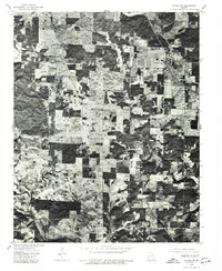 1976 Thayer SW1977 Print · USGSThe rural landscape of southern Missouri is captured here during the mid-1970s, showing the settlement and land-use patterns of the era. Genealogists and local historians can trace the street grid of Koshkonong and identify specific farmsteads and field boundaries across Howell County.
 - 1976 Map of Thayer NW, 1977 Print
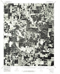 1976 Thayer NW1977 Print · USGSMissouri's agricultural heartland is frozen in time during the mid-seventies, showing the intersection of forest and field. Genealogists and local historians can trace the specific property lines and rural structures surrounding the settlement of Brandsville.
 - 1976 Map of Thayer SE, 1977 Print
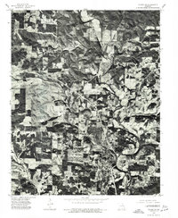 1976 Thayer SE1977 Print · USGSThe Oregon County borderlands come into sharp focus in the mid-1970s, showing the intersection of rural agriculture and small-town development. Researchers can trace the layout of Thayer and the winding course of the Spring River as they appeared decades ago.
End of results
Showing maps 1-3 of 3
Top cities of Oregon County
Frequently asked questions
- What are the different types of historical maps available for Oregon County?
- What is the oldest map of Oregon County?
- Where can I purchase historical maps of Oregon County for my home or office?
- Where can I download high-res historical maps of Oregon County?
- Are there historical topographic maps available for Oregon County?
- Is there historical aerial imagery available for Oregon County?
- Where are historical maps of Oregon County sourced from?