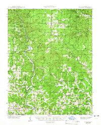
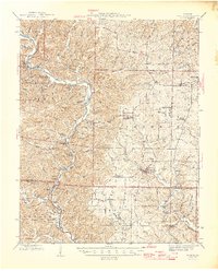
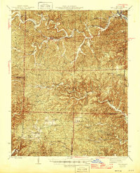
Old Maps of Ripley County, Missouri for Genealogy
Trace your family roots with 144 historic maps of Ripley County. These high-res maps reveal old neighborhoods, homesites, landmarks, and streets — helping you uncover where your ancestors lived and how the area evolved over time.
- Explore historic neighborhoods: Identify where your relatives may have lived in the 1800s or 1900s.
- Compare maps over time: Trace the changes in streets, buildings, and landmarks for multi-generational research.
- Perfect for genealogy & ancestry research: Used by family historians and researchers to map out lineage and migration.
These maps are an incredible resource for exploring your personal connection to Ripley County's past.
Ripley County, MO maps
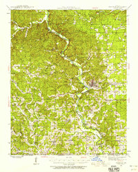
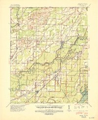
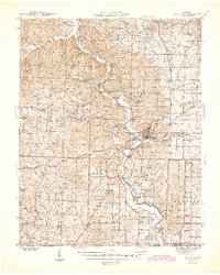
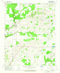
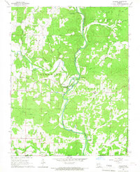
(144)- 1934 Map of Williamsville
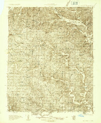 1934 Williamsville1934 Print · USGSThe Ozark foothills near the Wayne and Butler county line come into focus during the mid-1930s, showing a landscape of timbered hollows and nascent highways. Researchers can locate vanished rural landmarks like the Lone Star School, Kearney Cem, and the specialized Keener Cave Resort.4 unique versions available
 - 1935 Map of Acorn, 1936 Print
 1935 Acorn1936 Print · USGSRipley and Butler counties are captured in the mid-1930s just as drainage projects were reshaping the river bottomlands. Researchers can trace vanished rail stops and numerous combined community hubs like Spring Hill Sch & Cem, Venerable Sch, and Torch.
 - 1935 Map of Knobel, 1938 Print
 1935 Knobel1938 Print · USGSDuring the mid-1930s, the Arkansas-Missouri borderlands were defined by the rail lines and river bends of the Black River valley. Researchers can trace family roots through Peach Orchard, Hopewell Ch, and cemeteries like Al McNaner Cem.
 - 1935 Map of Reyno, 1938 Print
 1935 Reyno1938 Print · USGSRandolph and Clay counties are shown in the mid-1930s, documenting a river-dependent economy as the Ozarks meet the alluvial valley. Researchers can trace historic river crossings like Biggers Ferry and rural sites such as Johnson Cem and Cochrum Sch.3 unique versions available
 - 1939 Map of Doniphan, 1958 Print
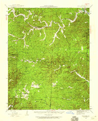
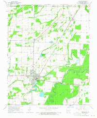
 1939 Doniphan1958 Print · USGSRipley County is captured in the late 1930s as a landscape of river-bend settlements and numerous rural schoolhouses. Genealogists can locate family landmarks like Ponder, Poynor, and several country churches including New Home Ch.3 unique versions available
 - 1940 Map of Williamsville
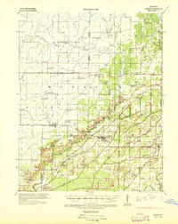
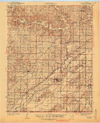
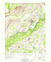
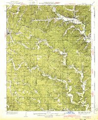 1940 Williamsville1940 Print · USGSThe eastern Ozarks at the start of the 1940s reveal a bustling rail-and-river economy centered on the junction of the Missouri Pacific and St Louis - San Francisco. Researchers can trace the unique immigrant history of Budapest or locate vanished landmarks like the Fire Tower CCC Camp and Barrett Mine.2 unique versions available
 - 1940 Map of Naylor
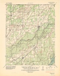
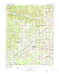 1940 Naylor1940 Print · USGSRipley and Butler counties are captured here just before the mid-century, showing a landscape defined by the Little Black River and a dense rail network. Genealogists can trace family roots through dozens of local sites like Sixteen to One Sch and the Military Cem.
 - 1941 Map of Gatewood
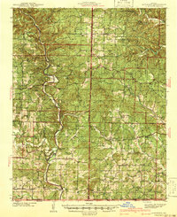 1941 Gatewood1941 Print · USGSThe Missouri Ozarks meet the Arkansas border in the 1930s, a period when the Eleven Point River was the lifeblood of remote forest communities. Researchers can locate dozens of country schoolhouses like Charter Oak Sch and river landmarks such as Stubblefield Ferry.
 - 1941 Map of Knobel, 1946 Print
 1941 Knobel1946 Print · USGSClay County at the onset of the 1940s is defined by the winding Black River and the critical rail junctions that sustained its small towns. Researchers can trace family roots through numerous rural landmarks like Masterson Cem, Brazil Sch & Ch, and the river crossing at Bennetts Ferry Bridge.2 unique versions available
 - 1944 Map of Naylor
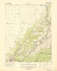
 1944 Naylor1944 Print · USGSThe Missouri-Arkansas border region in the early 1940s reveals a landscape shaped by the St Louis San Francisco railroad and the historic Military Road. Researchers can trace old family-named sites like Cochran Cem, Sewell Sch, and the riverside settlement of Naylor.2 unique versions available
 - 1944 Map of Van Buren, 1960 Print
 1944 Van Buren1960 Print · USGSThe Ozark hill country of Carter and Shannon counties appears here in the mid-1940s. Researchers can trace the St Louis San Francisco rail line or locate rural sites like Pleasant Site Cem, Chicopee, and the Bristoll Sch.2 unique versions available
 - 1944 Map of Grandin, 1962 Print
 1944 Grandin1962 Print · USGSDeep in the Ozarks during the 1940s, this area shows a landscape of ridge-top schools and river-bottom homesteads. Genealogists can trace family sites like McDowell Place or search for roots near Shiloh Cem and the Old Iron Mines.
 - 1945 Map of Doniphan
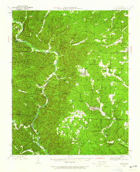
 1945 Doniphan1945 Print · USGSThe Current River valley and the railroad terminus at Doniphan are shown in the mid-1940s just as the region's river-camp culture was thriving. Genealogists can locate family names at Mill Creek Sch, Kennon Cem, and the settlement of Poynor.2 unique versions available
 - 1945 Map of Gatewood
 1945 Gatewood1945 Print · USGSRipley and Oregon counties are shown during the 1930s and 40s, a period defined by the growth of the national forest and river-based commerce. Genealogists can locate family landmarks like Stubblefield Ferry, Thomasons Mill, and schools such as Mt Carmel Sch.3 unique versions available
 - 1946 Map of Grandin
 1946 Grandin1946 Print · USGSThe Ozark hills of Carter and Ripley Counties are captured here in the mid-1940s, highlighting the area's timber and mining heritage. Researchers can locate vanished landmarks like Crossroads Sch, trace the Old Iron Mines, or find family plots at Shiloh Cem.2 unique versions available
 - 1946 Map of Van Buren
 1946 Van Buren1946 Print · USGSThe Ozark foothills of Carter County are shown here in the 1940s, dominated by the winding Current River and the sprawling Clark National Forest. Genealogists and hikers can trace the footprints of rural communities at Wilderness, Bristol Church, and Rinnard School.2 unique versions available
 - 1957 Map of Poplar Bluff, 1968 Print
 1957 Poplar Bluff1968 Print · USGSThe Missouri-Arkansas border region is captured here as the timber and rail industries shaped the Ozark foothills. Genealogists and historians can trace the Missouri Pacific Railroad through river towns like Pocahontas, Greenville, and Van Buren.3 unique versions available
 - 1959 Map of Poplar Bluff
 1959 Poplar Bluff1959 Print · USGSThe Missouri Ozarks and Arkansas borderlands meet in this late 1950s study of the region's diverse terrain and rail-fed towns. Researchers can trace the path of the Missouri Pacific Railroad through Poplar Bluff or locate smaller settlements like Birch Tree and Myrtle.
 - 1960 Map of Poplar Bluff
 1960 Poplar Bluff1960 Print · USGSSoutheast Missouri and Northeast Arkansas are captured here during the post-war era, showing the transition from the Ozark highlands to the Delta. Genealogists and historians can trace rail corridors like the St. Louis Southwestern RR and remote settlements such as Birch Tree and Warm Springs.
 - 1964 Map of Datto, 1965 Print
 1964 Datto1965 Print · USGSIn the mid-1960s, the Arkansas-Missouri border was a landscape of fertile bottomlands and evolving drainage systems. Genealogists can trace family roots at Hitt Cem and Grassyhead Ch or follow the St Louis-San Francisco rail line through Success.2 unique versions available
 - 1964 Map of Corning, 1965 Print
 1964 Corning1965 Print · USGSIn the mid-1960s, the Arkansas-Missouri borderlands near Corning were a landscape of river-bottom sloughs and precisely ditched farmland. Genealogists can trace family names across Allmandinger Cem and Williams Cem, or locate rural landmarks like New Home Ch and the Drive-in Theater.2 unique versions available
 - 1965 Map of Gatewood, 1967 Print
 1965 Gatewood1967 Print · USGSThe Missouri-Arkansas borderlands come to life in the mid-1960s, showing a landscape of forest lookouts and winding creek forks. Researchers can trace rural lineages through the Gatewood community and find old country landmarks like Johnson Chapel and the Mulvinia Lookout Tower.
 - 1965 Map of Bardley, 1967 Print
 1965 Bardley1967 Print · USGSThe Ozark woodlands of Oregon and Ripley County are captured here in the mid-1960s, showing a landscape defined by forestry and deep-cut creek hollows. Researchers can locate remote community landmarks like Pine Sch, Oak Ridge Ch, and the Briar Lookout Tower.2 unique versions available
 - 1966 Map of Billmore, 1967 Print
 1966 Billmore1967 Print · USGSThe Eleven Point River valley in the mid-1960s was a landscape of remote farmsteads and natural springs. You can trace early local history at Billmore and Calm, or locate legacy landmarks like Liberty Church and the distinctive Narrows.2 unique versions available
 - 1967 Map of Knobel
 1967 Knobel1967 Print · USGSNortheast Arkansas in the late 1960s reveals a landscape of river-bottom settlements and a sophisticated network of agricultural drainage. Trace the family roots of early residents near Corning, Success, and Knobel, or locate family sites at Richwoods Cem and Browns Chapel.
Showing maps 1-25 of 144
Top cities of Ripley County
Frequently asked questions
- What are the different types of historical maps available for Ripley County?
- What is the oldest map of Ripley County?
- Where can I purchase historical maps of Ripley County for my home or office?
- Where can I download high-res historical maps of Ripley County?
- Are there historical topographic maps available for Ripley County?
- Is there historical aerial imagery available for Ripley County?
- Where are historical maps of Ripley County sourced from?