1960s Maps of Ripley County, Missouri
Explore 14 historic maps of Ripley County from the 1960s. These maps offer a rare glimpse into what life looked like during the 1960s — showing old roads, neighborhoods, homes, and landmarks that have changed or disappeared over time.
Whether you're researching your family's past, planning a metal detecting trip, or studying how Ripley County's landscape evolved across the 1960s, these high-resolution maps are a powerful tool for exploring the history of this region.
- Focus on a specific era: All maps on this page are from the 1960s, giving you a focused view of this time period.
- See what’s changed: Compare century-old streets, trails, and buildings to today's modern landscape using overlays and satellite layers.
- Research with precision: Use these maps for genealogy, historical research, land use analysis, or educational projects.
- View, download, or print: Maps are fully viewable online in high resolution, and can be downloaded or printed for your own records.
Start exploring Ripley County's history through authentic maps from the 1960s. This is your window into the past.
Ripley County, MO maps
(14)- 1960 Map of Poplar Bluff
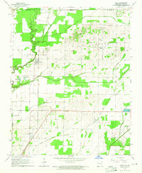
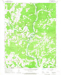
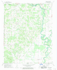
 1960 Poplar Bluff1960 Print · USGSSoutheast Missouri and Northeast Arkansas are captured here during the post-war era, showing the transition from the Ozark highlands to the Delta. Genealogists and historians can trace rail corridors like the St. Louis Southwestern RR and remote settlements such as Birch Tree and Warm Springs.
 - 1964 Map of Datto, 1965 Print
 1964 Datto1965 Print · USGSIn the mid-1960s, the Arkansas-Missouri border was a landscape of fertile bottomlands and evolving drainage systems. Genealogists can trace family roots at Hitt Cem and Grassyhead Ch or follow the St Louis-San Francisco rail line through Success.2 unique versions available
 - 1964 Map of Corning, 1965 Print
 1964 Corning1965 Print · USGSIn the mid-1960s, the Arkansas-Missouri borderlands near Corning were a landscape of river-bottom sloughs and precisely ditched farmland. Genealogists can trace family names across Allmandinger Cem and Williams Cem, or locate rural landmarks like New Home Ch and the Drive-in Theater.2 unique versions available
 - 1965 Map of Gatewood, 1967 Print
 1965 Gatewood1967 Print · USGSThe Missouri-Arkansas borderlands come to life in the mid-1960s, showing a landscape of forest lookouts and winding creek forks. Researchers can trace rural lineages through the Gatewood community and find old country landmarks like Johnson Chapel and the Mulvinia Lookout Tower.
 - 1965 Map of Bardley, 1967 Print
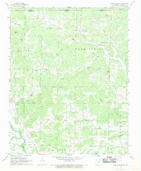
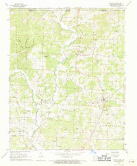
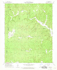
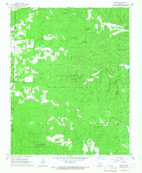 1965 Bardley1967 Print · USGSThe Ozark woodlands of Oregon and Ripley County are captured here in the mid-1960s, showing a landscape defined by forestry and deep-cut creek hollows. Researchers can locate remote community landmarks like Pine Sch, Oak Ridge Ch, and the Briar Lookout Tower.2 unique versions available
 - 1966 Map of Billmore, 1967 Print
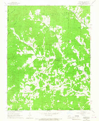
 1966 Billmore1967 Print · USGSThe Eleven Point River valley in the mid-1960s was a landscape of remote farmsteads and natural springs. You can trace early local history at Billmore and Calm, or locate legacy landmarks like Liberty Church and the distinctive Narrows.2 unique versions available
 - 1967 Map of Knobel
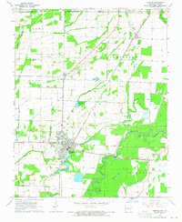
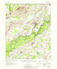 1967 Knobel1967 Print · USGSNortheast Arkansas in the late 1960s reveals a landscape of river-bottom settlements and a sophisticated network of agricultural drainage. Trace the family roots of early residents near Corning, Success, and Knobel, or locate family sites at Richwoods Cem and Browns Chapel.
 - 1967 Map of Warm Springs, 1969 Print
 1967 Warm Springs1969 Print · USGSThe Missouri-Arkansas border region comes alive in the late sixties, showcasing a landscape of Ozark springs and remote homesteads. Genealogists can trace family names through Upshaw Cem and Roach Cem or locate the quiet crossroads of Hamil and Tyer.2 unique versions available
 - 1968 Map of Grandin SW, 1969 Print
 1968 Grandin SW1969 Print · USGSRipley and Carter counties are captured in the late sixties as the federal government solidified forest and river protections. Researchers can find family-named landmarks and rural outposts including Good Hope Ch, Hofstader Cem, and the Panther Lookout Tower.2 unique versions available
 - 1968 Map of Supply, 1969 Print
 1968 Supply1969 Print · USGSThe Arkansas-Missouri borderlands come into focus in the late sixties as a network of small settlements and river bottoms. Researchers can locate family landmarks like Supply Ch, Ingram Cem, and the old community at Pitman.2 unique versions available
 - 1968 Map of Maynard, 1969 Print
 1968 Maynard1969 Print · USGSThe Fourche River valley and the town of Maynard are captured here in the late sixties as they appeared just south of the Missouri line. Genealogists can trace family landmarks and rural homesteads near Middlebrook, Barnett Cem, and Siloam Ch.
 - 1968 Map of Dalton, 1969 Print
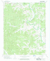 1968 Dalton1969 Print · USGSRandolph County sits at the Missouri border in the late sixties, where the Eleven Point River carves through the Ozark foothills. Researchers can pinpoint old homesteads and community hubs like Elm Store, Yadkin Ch, and Bryan Cem.2 unique versions available
 - 1968 Map of Grandin, 1969 Print
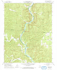
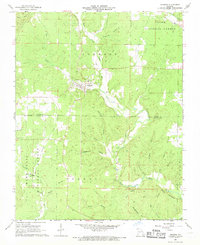 1968 Grandin1969 Print · USGSIn the Ozarks of the late 1960s, the town of Grandin sits at the junction of Carter and Ripley counties amidst a maze of river prongs and hollows. Genealogists can trace rural roots at Roan Cemetery, Shiloh Church, and along the banks of the North Prong Little Black River.
 - 1968 Map of Handy, 1970 Print
 1968 Handy1970 Print · USGSThe Ozark highlands of Ripley and Carter counties are shown here in the late sixties, where small settlements like Handy persist within the Mark Twain National Forest. Local history researchers can trace old routes like the Tram and locate rural landmarks such as Big Barren Ch and the Bristol Cem.3 unique versions available
End of results
Showing maps 1-14 of 14
Top cities of Ripley County
Frequently asked questions
- What are the different types of historical maps available for Ripley County?
- What is the oldest map of Ripley County?
- Where can I purchase historical maps of Ripley County for my home or office?
- Where can I download high-res historical maps of Ripley County?
- Are there historical topographic maps available for Ripley County?
- Is there historical aerial imagery available for Ripley County?
- Where are historical maps of Ripley County sourced from?