1950s Maps of Granite County, Montana
Explore 8 historic maps of Granite County from the 1950s. These maps offer a rare glimpse into what life looked like during the 1950s — showing old roads, neighborhoods, homes, and landmarks that have changed or disappeared over time.
Whether you're researching your family's past, planning a metal detecting trip, or studying how Granite County's landscape evolved across the 1950s, these high-resolution maps are a powerful tool for exploring the history of this region.
- Focus on a specific era: All maps on this page are from the 1950s, giving you a focused view of this time period.
- See what’s changed: Compare century-old streets, trails, and buildings to today's modern landscape using overlays and satellite layers.
- Research with precision: Use these maps for genealogy, historical research, land use analysis, or educational projects.
- View, download, or print: Maps are fully viewable online in high resolution, and can be downloaded or printed for your own records.
Start exploring Granite County's history through authentic maps from the 1950s. This is your window into the past.
Granite County, MT maps
(8)- 1955 Map of Dillon, 1978 Print
 1955 Dillon1978 Print · USGSSouthwest Montana at the dawn of the interstate era reveals a landscape of high-mountain ranching and historic mining camps. Trace the routes of the Union Pacific through Dillon and Armstead, or locate early settlements like Bannack and Wisdom.2 unique versions available
 - 1957 Map of Dillon
 1957 Dillon1957 Print · USGSSouthwest Montana and Idaho in the mid-fifties reveal a high-country landscape of mountain ranges and ranching valleys. Genealogists can trace family holdings and rail stops along the Union Pacific Railroad, from Dillon to historic Virginia City and Twin Bridges.
 - 1958 Map of Butte
 1958 Butte1958 Print · USGSWestern Montana's mining and rail corridors are captured in the late fifties, from the urban bustle of the Copper King cities to high mountain passes. Researchers can trace the path of the Milwaukee St Paul and Pacific through Deer Lodge and locate remote outposts like Potomac Post Office.5 unique versions available
 - 1958 Map of Dillon
 1958 Dillon1958 Print · USGSSouthwestern Montana during the late fifties reveals a high-country landscape defined by the Continental Divide and a legacy of mountain mining. Genealogists and historians can trace rail lines like the Union Pacific or locate early industrial sites including the Hecla Mine and Ermont Mine.
 - 1958 Map of Drummond, 1960 Print
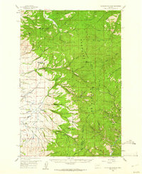
 1958 Drummond1960 Print · USGSDrummond and the surrounding Clark Fork valley are captured here in the late fifties, showcasing a critical Montana rail and river corridor. Genealogists and rail historians can trace the paths of the Northern Pacific through settlements like New Chicago and Hall.3 unique versions available
 - 1959 Map of Cleveland Mountain, 1961 Print
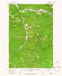
 1959 Cleveland Mountain1961 Print · USGSRavalli and Missoula counties meet along the high ridges of the Sapphire Mountains during the late fifties. Genealogists and historians can locate the Ambrose settlement, trace early timber and mining routes like Woodchuck, or find the Lone Rock Sch near the river.2 unique versions available
 - 1959 Map of Bearmouth, 1961 Print
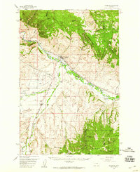
 1959 Bearmouth1961 Print · USGSGranite County in the late fifties shows a landscape defined by the deep canyons of the Clark Fork and high mountain ridges. Researchers can trace historic transportation routes like the Mullan Road and find remote sites such as Griffith Cabin and the Conn Ranch.3 unique versions available
 - 1959 Map of Ravenna, 1961 Print
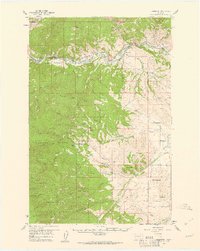
 1959 Ravenna1961 Print · USGSIn the late 1950s, this mountainous border between Missoula and Granite Counties was a hub of river-and-rail transport. Researchers can trace the dual tracks of the Northern Pacific and Milwaukee Road, locating vanished stops like Nimrod and the old settlement at Quigley.2 unique versions available
End of results
Showing maps 1-8 of 8
Top cities of Granite County
Frequently asked questions
- What are the different types of historical maps available for Granite County?
- What is the oldest map of Granite County?
- Where can I purchase historical maps of Granite County for my home or office?
- Where can I download high-res historical maps of Granite County?
- Are there historical topographic maps available for Granite County?
- Is there historical aerial imagery available for Granite County?
- Where are historical maps of Granite County sourced from?