1900-1909 Maps of Granite County, Montana
Explore 3 historic maps of Granite County from 1900-1909. These maps offer a rare glimpse into what life looked like during the 1900s — showing old roads, neighborhoods, homes, and landmarks that have changed or disappeared over time.
Whether you're researching your family's past, planning a metal detecting trip, or studying how Granite County's landscape evolved across the 1900s, these high-resolution maps are a powerful tool for exploring the history of this region.
- Focus on a specific era: All maps on this page are from the 1900s, giving you a focused view of this time period.
- See what’s changed: Compare century-old streets, trails, and buildings to today's modern landscape using overlays and satellite layers.
- Research with precision: Use these maps for genealogy, historical research, land use analysis, or educational projects.
- View, download, or print: Maps are fully viewable online in high resolution, and can be downloaded or printed for your own records.
Start exploring Granite County's history through authentic maps from the 1900s. This is your window into the past.
Granite County, MT maps
(3)- 1903 Map of Bonner
 1903 Bonner1903 Print · USGSMissoula and the surrounding river canyons come to life in this turn-of-the-century survey during the height of early rail expansion. Trace the original path of the Northern Pacific through mountain passes and locate early settlements like Bonner, Potomac, and Clinton.4 unique versions available
 - 1908 Map of Philipsburg
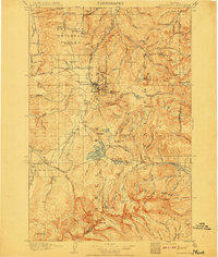 1908 Philipsburg1908 Print · USGSGranite County at the height of its mining era features a landscape shaped by mineral wealth and the high peaks of the Divide. Genealogists and historians can trace industrial roots at Philipsburg, Southern Cross, and the Stamp Mill near Combination.3 unique versions available
 - 1909 Map of Sapphire
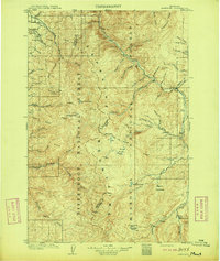 1909 Sapphire1909 Print · USGSThe high Montana wilderness of the Sapphire and Bitterroot ranges is captured in the early 1900s, showing the border between Granite and Ravalli counties. Genealogists and researchers can trace family-named landmarks like Dominic Butte or explore remote basins like Frogpond Basin and Moose Meadows.3 unique versions available
End of results
Showing maps 1-3 of 3
Top cities of Granite County
Frequently asked questions
- What are the different types of historical maps available for Granite County?
- What is the oldest map of Granite County?
- Where can I purchase historical maps of Granite County for my home or office?
- Where can I download high-res historical maps of Granite County?
- Are there historical topographic maps available for Granite County?
- Is there historical aerial imagery available for Granite County?
- Where are historical maps of Granite County sourced from?