1980s Maps of Granite County, Montana
Explore 16 historic maps of Granite County from the 1980s. These maps offer a rare glimpse into what life looked like during the 1980s — showing old roads, neighborhoods, homes, and landmarks that have changed or disappeared over time.
Whether you're researching your family's past, planning a metal detecting trip, or studying how Granite County's landscape evolved across the 1980s, these high-resolution maps are a powerful tool for exploring the history of this region.
- Focus on a specific era: All maps on this page are from the 1980s, giving you a focused view of this time period.
- See what’s changed: Compare century-old streets, trails, and buildings to today's modern landscape using overlays and satellite layers.
- Research with precision: Use these maps for genealogy, historical research, land use analysis, or educational projects.
- View, download, or print: Maps are fully viewable online in high resolution, and can be downloaded or printed for your own records.
Start exploring Granite County's history through authentic maps from the 1980s. This is your window into the past.
Granite County, MT maps
(16)- 1984 Map of Missoula East
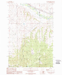
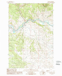
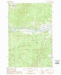
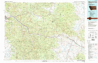 1984 Missoula East1984 Print · USGSThe Clark Fork valley and the Garnet Range are shown here in the mid-1980s as the region's timber and rail heritage remained prominent. Researchers can trace the Burlington Northern line and locate old mining sites like Garnet and the Copper Cliff Mine.
 - 1989 Map of Cleveland Mountain
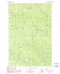 1989 Cleveland Mountain1989 Print · USGSThe high Bitterroot and Lolo National Forests meet here in the late eighties, documenting a remote mountain landscape at the Ravalli and Granite county line. Researchers can locate the Cleveland Mine, trace the Bitterroot Divide, and explore naming conventions across Cooney Ridge and Ambrose Saddle.
 - 1989 Map of Iris Point
 1989 Iris Point1989 Print · USGSThe Missoula and Granite county line meets along the river canyons of western Montana in the late eighties. Researchers can trace the wild reaches of the Welcome Creek Wilderness and locate landmarks like the Elliott Airstrip and Bonita FS Station.
 - 1989 Map of Spink Point
 1989 Spink Point1989 Print · USGSGranite County is seen in the late eighties as a rugged hub of mining activity and forest boundary lines. Researchers can trace historic mineral claims like the Alps Mine, Jumbo Mine, and Edelman Mine along the steep slopes of Sliderock Mountain.
 - 1989 Map of Dunkleberg Creek
 1989 Dunkleberg Creek1989 Print · USGSGranite and Powell Counties were centers of mountain industry in the 1980s, balancing timber management with high-altitude mining. Researchers can trace historical extraction at the Forest Rose Mine or follow the Old Railroad Grade past the settlement of Jens.
 - 1989 Map of Hall
 1989 Hall1989 Print · USGSGranite County's Flint Creek valley was a hub of mining and ranching during the 1980s. Researchers can trace the Old Railroad Grade past Hall and Stone or locate historical extraction sites like the Strip Mine and various Prospects near Douglas Mountain.
 - 1989 Map of Grayhorse Creek
 1989 Grayhorse Creek1989 Print · USGSThe Bitterroot Valley in the late eighties shows a landscape defined by irrigation and mountain drainages. Genealogists and researchers can locate Lone Rock School, trace the Bitterroot Irrigation District Canal, and find the Slocum Prospect.
 - 1989 Map of Limestone Ridge
 1989 Limestone Ridge1989 Print · USGSGranite and Powell counties come together along this mountainous divide in the late 1980s. Researchers can trace the Old Railroad Grade along the CLARK FORK and locate landmarks like Limestone Ridge and Sturgeon Mountain.
 - 1989 Map of Nirling Hill
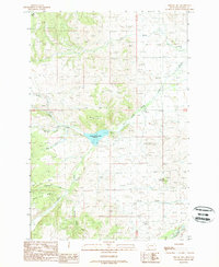 1989 Nirling Hill1989 Print · USGSGranite County's high ridges and mountain drainages are captured in the late eighties, documenting a remote landscape of ranching and water management. Researchers can locate Conn Ranch, trace the reach of Silver King Ridge, and study the Lower Willow Creek Reservoir.
 - 1989 Map of Bearmouth
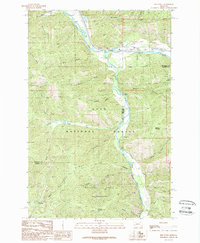
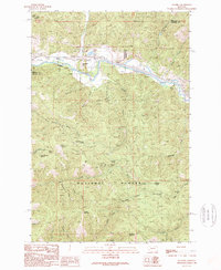
 1989 Bearmouth1989 Print · USGSThe Clark Fork river valley in western Montana is shown here during the late eighties, showing a landscape defined by steep gulches and mountain ridges. Local historians can trace mining activity through several prospects and tailings sites located near Bearmouth and Snyder Gulch.
 - 1989 Map of Grizzly Point
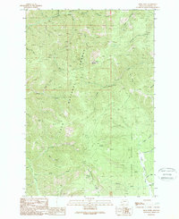
 1989 Grizzly Point1989 Print · USGSGranite County at the close of the 1980s reveals a landscape of protected wilderness and national forest lands. Researchers can locate the historical Quigley (Site), trace the Wilderness Boundary, or identify old camps like Harrys Flat Campground.
 - 1989 Map of Ravenna
 1989 Ravenna1989 Print · USGSThe Clark Fork corridor in the late eighties shows a landscape of mountain transit and public forest management. Researchers can trace the rail and road infrastructure through Beavertail Tunnels and locate local sites like Bonita and Mormon Spring.
 - 1989 Map of Harvey Point
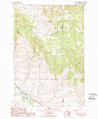
 1989 Harvey Point1989 Print · USGSGranite County in the late eighties shows a high-country landscape where the Lolo National Forest meets the Deerlodge National Forest. Researchers can trace old Pack Trails and identify remote landmarks like Harvey Cabin, Horsethief Spring, and the Silver King Mountain summit.
 - 1989 Map of Medicine Tree Hill
 1989 Medicine Tree Hill1989 Print · USGSThe Clark Fork river valley in the late eighties serves as a vital corridor through the mountains of Western Montana. Researchers can trace the riverfront rail and road connections through Nimrod and Bearmouth or explore the rugged slopes of Medicine Tree Hill.
 - 1989 Map of Drummond
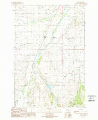
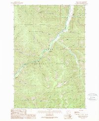
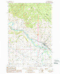 1989 Drummond1989 Print · USGSThe Clark Fork valley in the late 1980s shows a landscape of mountain gulches and river-bottom agriculture. Researchers can trace historic transport routes like the Old Railroad Grade and locate settlements at Drummond and New Chicago.
 - 1989 Map of Elk Mountain
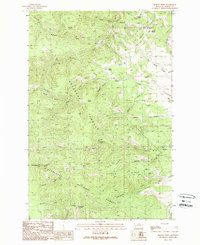
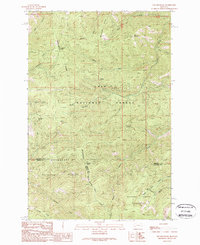 1989 Elk Mountain1989 Print · USGSThe high Montana ridges near the Bitterroot Divide appear in detail in the late eighties, showing a landscape defined by forest management and wilderness preservation. Researchers can trace the drainage patterns of Moccasin Creek or locate remote landmarks like Last Drink Springs and Elk Mountain.
End of results
Showing maps 1-16 of 16
Top cities of Granite County
Frequently asked questions
- What are the different types of historical maps available for Granite County?
- What is the oldest map of Granite County?
- Where can I purchase historical maps of Granite County for my home or office?
- Where can I download high-res historical maps of Granite County?
- Are there historical topographic maps available for Granite County?
- Is there historical aerial imagery available for Granite County?
- Where are historical maps of Granite County sourced from?