1900-1909 Maps of Hill County, Montana
Explore 7 historic maps of Hill County from 1900-1909. These maps offer a rare glimpse into what life looked like during the 1900s — showing old roads, neighborhoods, homes, and landmarks that have changed or disappeared over time.
Whether you're researching your family's past, planning a metal detecting trip, or studying how Hill County's landscape evolved across the 1900s, these high-resolution maps are a powerful tool for exploring the history of this region.
- Focus on a specific era: All maps on this page are from the 1900s, giving you a focused view of this time period.
- See what’s changed: Compare century-old streets, trails, and buildings to today's modern landscape using overlays and satellite layers.
- Research with precision: Use these maps for genealogy, historical research, land use analysis, or educational projects.
- View, download, or print: Maps are fully viewable online in high resolution, and can be downloaded or printed for your own records.
Start exploring Hill County's history through authentic maps from the 1900s. This is your window into the past.
Hill County, MT maps
(7)- 1904 Map of Yantic
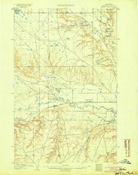 1904 Yantic1904 Print · USGSNorthern Montana ranching life is frozen in time on this 1904 survey of the Milk River valley. Researchers can trace early homesteads like Potter's Ranch and Empire Ranch or follow the route of the Great Northern R. R. through Yantic.2 unique versions available
 - 1904 Map of Havre
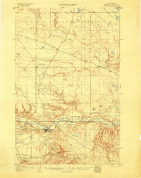 1904 Havre1904 Print · USGSHavre and the Milk River valley are captured in this early century survey as the region transitioned from a frontier military outpost to a railroad-driven settlement. Researchers can trace the original locations of numerous family homesteads like Conley's Ranch and Mc Grew's Ranch, alongside the sprawling Fort Assinniboine Mil. Res..2 unique versions available
 - 1904 Map of Assinniboine
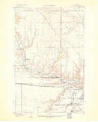 1904 Assinniboine1904 Print · USGSNorthern Montana ranching and military life are captured here at the start of the century, centered on the Milk River valley. Researchers can trace the layout of Fort Assinniboine and find family-named landmarks like Meili Ranch or Kelleys Ranch.2 unique versions available
 - 1904 Map of Boxelder, 1959 Print
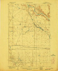
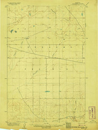
 1904 Boxelder1959 Print · USGSChouteau County was a land of sprawling cattle ranches and newly laid tracks at the start of the 1900s. Genealogists and local historians can trace early homesteads like Armentrout's Ranch and follow the route of the Great Northern R R.
 - 1906 Map of Kremlin
 1906 Kremlin1906 Print · USGSUpper Chouteau County ranching lands and the railroad corridor are captured here during the first decade of the twentieth century. Genealogists and local historians can locate early homesteads like Connollys Ranch and Holdens Ranch along the path of the Great Northern R R.2 unique versions available
 - 1906 Map of Lonesome
 1906 Lonesome1906 Print · USGSLonesome Prairie in north-central Montana appears here at the dawn of the twentieth century, before widespread settlement. Researchers can locate early outposts like Godfrey's Ranch and trace the drainage of Fourteenmile Coulee and Dry Fork Coulee.2 unique versions available
 - 1906 Map of Boxelder
 1906 Boxelder1906 Print · USGSThe northern Montana high plains are captured here in the early twentieth century as the railroad transformed the ranching economy. Genealogists and local historians can locate early family holdings like Schwartz's Ranch and Wedeking's Ranch or trace the Great Northern RR through Boxelder.
End of results
Showing maps 1-7 of 7
Top cities of Hill County
Frequently asked questions
- What are the different types of historical maps available for Hill County?
- What is the oldest map of Hill County?
- Where can I purchase historical maps of Hill County for my home or office?
- Where can I download high-res historical maps of Hill County?
- Are there historical topographic maps available for Hill County?
- Is there historical aerial imagery available for Hill County?
- Where are historical maps of Hill County sourced from?