Old Maps of Hill County, Montana for Metal Detecting
Plan your next treasure hunt with 482 historic maps of Hill County. Find old homesites, ghost towns, trails, and gathering spots that may be lost to time — perfect for identifying promising metal detecting locations.
- Locate forgotten sites: Uncover places like long-lost settlements, abandoned rail lines, or gathering spots.
- Plan better hunts: Use map overlays combined with LiDAR or satellite views to narrow in on historically rich areas.
- Made for detectorists: Thousands of hobbyists use these maps to discover relics, coins, and hidden history.
Use these historic maps to boost your research and find new opportunities beneath the surface of Hill County.
Hill County, MT maps
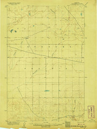
(482)- 1904 Map of Yantic
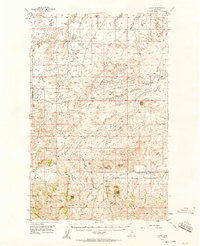
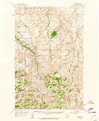
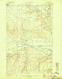 1904 Yantic1904 Print · USGSNorthern Montana ranching life is frozen in time on this 1904 survey of the Milk River valley. Researchers can trace early homesteads like Potter's Ranch and Empire Ranch or follow the route of the Great Northern R. R. through Yantic.2 unique versions available
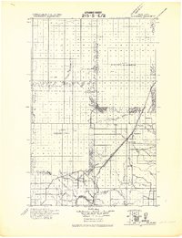
 - 1904 Map of Havre
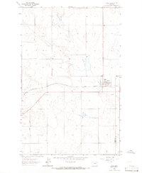
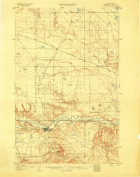 1904 Havre1904 Print · USGSHavre and the Milk River valley are captured in this early century survey as the region transitioned from a frontier military outpost to a railroad-driven settlement. Researchers can trace the original locations of numerous family homesteads like Conley's Ranch and Mc Grew's Ranch, alongside the sprawling Fort Assinniboine Mil. Res..2 unique versions available
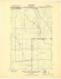
 - 1904 Map of Assinniboine
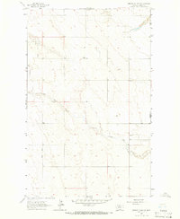
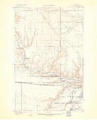 1904 Assinniboine1904 Print · USGSNorthern Montana ranching and military life are captured here at the start of the century, centered on the Milk River valley. Researchers can trace the layout of Fort Assinniboine and find family-named landmarks like Meili Ranch or Kelleys Ranch.2 unique versions available
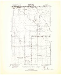
 - 1904 Map of Boxelder, 1959 Print
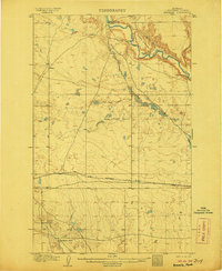
 1904 Boxelder1959 Print · USGSChouteau County was a land of sprawling cattle ranches and newly laid tracks at the start of the 1900s. Genealogists and local historians can trace early homesteads like Armentrout's Ranch and follow the route of the Great Northern R R.
 - 1906 Map of Kremlin
 1906 Kremlin1906 Print · USGSUpper Chouteau County ranching lands and the railroad corridor are captured here during the first decade of the twentieth century. Genealogists and local historians can locate early homesteads like Connollys Ranch and Holdens Ranch along the path of the Great Northern R R.2 unique versions available
 - 1906 Map of Lonesome
 1906 Lonesome1906 Print · USGSLonesome Prairie in north-central Montana appears here at the dawn of the twentieth century, before widespread settlement. Researchers can locate early outposts like Godfrey's Ranch and trace the drainage of Fourteenmile Coulee and Dry Fork Coulee.2 unique versions available
 - 1906 Map of Boxelder
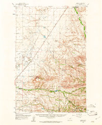
 1906 Boxelder1906 Print · USGSThe northern Montana high plains are captured here in the early twentieth century as the railroad transformed the ranching economy. Genealogists and local historians can locate early family holdings like Schwartz's Ranch and Wedeking's Ranch or trace the Great Northern RR through Boxelder.
 - 1912 Map of Zurich
 1912 Zurich1912 Print · USGSNorthern Montana ranchlands and rail towns are captured here in the early twentieth century before the full development of modern irrigation. Genealogists and historians can locate early family-named sites like Corregan Ranch and Kerrs Coalmine along the Great Northern railroad line.
 - 1912 Map of Thibedeau Lake
 1912 Thibedeau Lake1912 Print · USGSNorthern Montana's ranching frontier and rail corridors are captured here just after the turn of the century. Genealogists and historians can trace the early foundations of Havre and Fort Assinniboine, alongside family landmarks like Lohman's Ranch and Connolly Ranch.
 - 1919 Map of Big Sandy
 1919 Big Sandy1919 Print · USGSBig Sandy and the plains of Northern Montana are captured here just after the Great War, as the railroad and river trade defined local life. Genealogists and historians can trace the Great Northern Railway Line through Boxelder and Virgelle, or locate the Ferry crossing on the Missouri River.2 unique versions available
 - 1919 Map of Alma
 1919 Alma1919 Print · USGSNorthern Montana’s borderlands are captured here during the homesteading era, when the railroad drove the birth of new prairie towns. Genealogists and historians can trace the early layout of Joplin, Rudyard, and the Goldstone P.O. along the Great Northern R. R.
 - 1920 Map of Gildford
 1920 Gildford1920 Print · USGSNorthern Montana's high plains meet the Canadian border in this era of early rail expansion and homesteading. Genealogists and local historians can trace family-named outposts and rural junctions like Pugsley & Simpson, Wilson's Crossing, and Lilacs.
 - 1943 Map of Gildford
 1943 Gildford1943 Print · USGSSettlement and ranching define this Montana borderland during the early twentieth century, showing the rail-led growth of the northern plains. Researchers can trace the path of the Great Northern Railroad through Gildford or locate vanished sites like Lilacs and Fairchild.
 - 1953 Map of Havre, 1967 Print
 1953 Havre1967 Print · USGSNorthern Montana’s Hi-Line comes into focus in the mid-fifties, centered on the Milk River and the critical Great Northern rail link. Genealogists can trace small sidings and settlements like Assinniboine, Laredo, and Box Elder alongside the Fort Belknap Agency.3 unique versions available
 - 1954 Map of Shelby, 1967 Print
 1954 Shelby1967 Print · USGSNorthern Montana's Hi-Line is captured in the mid-fifties, showing a landscape shaped by the Great Northern rail and early oil development. Trace family roots in Shelby and Conrad, or locate rural landmarks like Goose Bill Butte and the Rocky Boys Indian Reservation.3 unique versions available
 - 1956 Map of Lloyd, 1958 Print
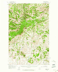
 1956 Lloyd1958 Print · USGSThe northern slopes of the Bearpaw Mountains come into focus in the mid-1950s, showing a landscape of high-plains ranching and early energy development. Genealogists and researchers can locate old rural school sites like Logie Sch and Lloyd Sch or trace the early Gas Wells near Threemile Coulee.2 unique versions available
 - 1957 Map of Havre
 1957 Havre1957 Print · USGSNorth-central Montana at the mid-century is defined by the vital Great Northern rail corridor and the winding Milk River. Researchers can trace old settlements like Laredo and Savoy, or locate historic sites such as the Hays (old) Sub Agency and the Chinook No 1 mine.
 - 1958 Map of Shelby
 1958 Shelby1958 Print · USGSNorthern Montana’s high plains and the Sweetgrass Hills come to life in the late fifties as the Tiber Dam begins to reshape the Marias River valley. Genealogists and historians can trace rail-town lineages along the Great Northern line and locate sites like the Hull Coal Mine or Sweet Grass.
 - 1958 Map of Havre
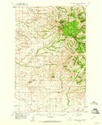
 1958 Havre1958 Print · USGSUpper Montana in the late fifties was a landscape of remote rail towns and vast high-plain ranges. Genealogists and historians can trace the Great Northern railroad through Havre, Chinook, and the Fort Belknap Indian Reservation.
 - 1959 Map of Warrick, 1961 Print
 1959 Warrick1961 Print · USGSThe Bearpaw Mountains of North Central Montana were still a landscape of remote ranching and reservation life in the late fifties. Researchers can trace the grounds of the Upper Dog Creek Sch, the Silver King Mine, and the isolated community of Warrick.3 unique versions available
 - 1959 Map of Laredo, 1961 Print
 1959 Laredo1961 Print · USGSNorth-central Montana at the close of the fifties reveals a landscape defined by the Great Northern railroad and the Rocky Boy Indian Reservation. Researchers can trace old ranch sites like Champagne Ranch and vanished landmarks like the Sangrey Sch.2 unique versions available
 - 1959 Map of Centennial Mountain, 1961 Print
 1959 Centennial Mountain1961 Print · USGSThe northern Bearpaw Mountains and the Rocky Boy Indian Reservation are captured here in the late fifties. Researchers can trace the legacy of local resource extraction and high-country landmarks like the Rocky Boy Mine, Centennial Mountain, and Ryan Butte.3 unique versions available
 - 1959 Map of Shambo, 1961 Print
 1959 Shambo1961 Print · USGSMontana's high country south of Havre is detailed here in the late fifties, where the plains meet the rising Bear Paw Mountains. Researchers can locate remote rural institutions like Shambo Sch, the boundaries of the Rocky Boy Indian Reservation, and family landmarks like Rotary Hill.3 unique versions available
 - 1963 Map of Joplin, 1965 Print
 1963 Joplin1965 Print · USGSLiberty County agricultural life in the early sixties centers on the rail-side grain hub of Joplin. Genealogists and historians can trace the local road network including Bison Road, the Great Northern rail line, and the siding at Buelow.
 - 1963 Map of Bobcat Coulee SE, 1966 Print
 1963 Bobcat Coulee SE1966 Print · USGSNorthern Montana's high plains come into focus in the early sixties, showing the rural landscape along the Liberty and Hill county line. Researchers can locate the Tingdahl School and trace the winding course of Little Sage Creek through this quiet cattle-and-grain country.
Showing maps 1-25 of 482
Top cities of Hill County
Frequently asked questions
- What are the different types of historical maps available for Hill County?
- What is the oldest map of Hill County?
- Where can I purchase historical maps of Hill County for my home or office?
- Where can I download high-res historical maps of Hill County?
- Are there historical topographic maps available for Hill County?
- Is there historical aerial imagery available for Hill County?
- Where are historical maps of Hill County sourced from?