1910s Maps of Hill County, Montana
Explore 4 historic maps of Hill County from the 1910s. These maps offer a rare glimpse into what life looked like during the 1910s — showing old roads, neighborhoods, homes, and landmarks that have changed or disappeared over time.
Whether you're researching your family's past, planning a metal detecting trip, or studying how Hill County's landscape evolved across the 1910s, these high-resolution maps are a powerful tool for exploring the history of this region.
- Focus on a specific era: All maps on this page are from the 1910s, giving you a focused view of this time period.
- See what’s changed: Compare century-old streets, trails, and buildings to today's modern landscape using overlays and satellite layers.
- Research with precision: Use these maps for genealogy, historical research, land use analysis, or educational projects.
- View, download, or print: Maps are fully viewable online in high resolution, and can be downloaded or printed for your own records.
Start exploring Hill County's history through authentic maps from the 1910s. This is your window into the past.
Hill County, MT maps
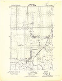
(4)- 1912 Map of Zurich
 1912 Zurich1912 Print · USGSNorthern Montana ranchlands and rail towns are captured here in the early twentieth century before the full development of modern irrigation. Genealogists and historians can locate early family-named sites like Corregan Ranch and Kerrs Coalmine along the Great Northern railroad line.
 - 1912 Map of Thibedeau Lake
 1912 Thibedeau Lake1912 Print · USGSNorthern Montana's ranching frontier and rail corridors are captured here just after the turn of the century. Genealogists and historians can trace the early foundations of Havre and Fort Assinniboine, alongside family landmarks like Lohman's Ranch and Connolly Ranch.
 - 1919 Map of Big Sandy
 1919 Big Sandy1919 Print · USGSBig Sandy and the plains of Northern Montana are captured here just after the Great War, as the railroad and river trade defined local life. Genealogists and historians can trace the Great Northern Railway Line through Boxelder and Virgelle, or locate the Ferry crossing on the Missouri River.2 unique versions available
 - 1919 Map of Alma
 1919 Alma1919 Print · USGSNorthern Montana’s borderlands are captured here during the homesteading era, when the railroad drove the birth of new prairie towns. Genealogists and historians can trace the early layout of Joplin, Rudyard, and the Goldstone P.O. along the Great Northern R. R.
End of results
Showing maps 1-4 of 4
Top cities of Hill County
Frequently asked questions
- What are the different types of historical maps available for Hill County?
- What is the oldest map of Hill County?
- Where can I purchase historical maps of Hill County for my home or office?
- Where can I download high-res historical maps of Hill County?
- Are there historical topographic maps available for Hill County?
- Is there historical aerial imagery available for Hill County?
- Where are historical maps of Hill County sourced from?