Old Maps of Lincoln County, Montana for Academic Research
Study the evolution of Lincoln County with 720 high-resolution historic maps. Whether you're teaching, researching, or modeling changes in land use, these maps provide essential visual documentation of urban, environmental, and geographic change.
- Analyze long-term change: Track patterns in development, transportation, and natural features.
- Ideal for environmental or urban studies: Support academic projects with primary historical map data.
- Use in the classroom or lab: Educators and researchers rely on these maps to bring historical context to life.
These maps are a powerful tool for teaching, research, and visualizing how Lincoln County has changed over the decades.
Lincoln County, MT maps
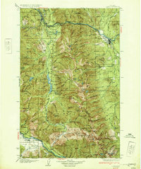
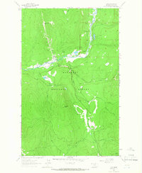
(720)- 1911 Map of Priest Lake, 1954 Print
 1911 Priest Lake1954 Print · USGSThe Idaho Panhandle during the early 1900s was a landscape of deep lakes and high-altitude mining operations connected by new rail lines. Genealogists and historians can trace pioneer settlements like Port Hill and Coolin, or locate remote industrial sites such as the Queen Mine and Mountain Chief Mine.
 - 1913 Map of Priest Lake
 1913 Priest Lake1913 Print · USGSThe Idaho Panhandle was a rugged network of rail sidings and mining camps in the years before the Great War. Genealogists and historians can trace old homesteads and depots from Sandpoint up to the Continental Mine and the remote border crossing at Addie.3 unique versions available
 - 1913 Map of Stryker, 1960 Print
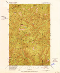
 1913 Stryker1960 Print · USGSNorthwest Montana at the start of the twentieth century was a landscape of remote rail outposts and high-country forestry along the Great Northern. Researchers can locate vanished infrastructure like the Meadow Creek School or trace early forest service history at Point of Rock Ranger Station.
 - 1916 Map of Stryker
 1916 Stryker1916 Print · USGSRailroad-driven development in the early twentieth century defined the corridor from Stryker to Olney along the Great Northern line. Researchers can trace the era's remote infrastructure through landmarks like Butcher Cabin and the Glen Lake School.3 unique versions available
 - 1920 Map of Libby
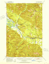
 1920 Libby1920 Print · USGSNorthwest Montana in the early twentieth century shows a landscape shaped by the Great Northern RR and industrial mining. You can locate family landmarks like Morrow Ranch, the Snowstorm Mines, and early post offices at Troy and Heron.
 - 1920 Map of Jennings
 1920 Jennings1920 Print · USGSNorthwest Montana in the early twenties is captured here as a landscape of timber, rail, and isolated homesteads. Genealogists can trace family-named locations such as Corries Ranch and Deegan Ranch, or locate the site of the Mamicke P.O. near the Fisher River.
 - 1930 Map of Libby, 1960 Print
 1930 Libby1960 Print · USGSNorthwestern Montana at the opening of the 1930s is a rugged domain of mountain mining and timber camps. Genealogists and researchers can trace early settlers through labels like Old Town, Bull Lake Sch, and high-country operations such as the Snowshoe Mine.
 - 1932 Map of Libby
 1932 Libby1932 Print · USGSThe Kootenai River valley and surrounding mountain ranges are captured here in the early 1930s during the height of the region's mining and timber era. Genealogists and historians can locate remote landmarks like Old Town, the Snowshoe Mine, and early rural schools including Bull Lake Sch.3 unique versions available
 - 1932 Map of Trout Creek, 1955 Print
 1932 Trout Creek1955 Print · USGSThe Clark Fork River corridor in the 1930s shows a landscape of mountain rail travel and early forest management. Genealogists and historians can locate rural schools like Ayers School, local industry at Tuscor Mill, and old mining sites such as the Jack White Mine.
 - 1935 Map of Thompson Lakes
 1935 Thompson Lakes1935 Print · USGSNorthwestern Montana in the mid-thirties was a rugged domain of timber management and rail-line outposts. Researchers can trace the Great Northern Ry through Jennings or locate remote schools like the Thompson River Sch and Manicke Sch.3 unique versions available
 - 1935 Map of Trout Creek, 1949 Print
 1935 Trout Creek1949 Print · USGSThe Clark Fork valley and the mining districts of Shoshone County are caught in high detail in the 1930s. Genealogists and historians can trace rail-side schools like Tuscor Sch, the operations at Jack Waite Mine, and old settlements from Noxon to Mace.
 - 1936 Map of Trout Creek
 1936 Trout Creek1936 Print · USGSThe Clark Fork valley and the Bitterroot mountains are captured here in the mid-1930s, showing a landscape defined by timber and mining. Researchers can trace the industrial footprint of the Tuscor Mill, remote operations like the Jack Waite Mine, and old mountain schools such as Flat Sch.2 unique versions available
 - 1937 Map of Thompson Falls
 1937 Thompson Falls1937 Print · USGSThe Clark Fork river valley and the high Cabinet Mountains are documented here in the mid-1930s. Genealogists and researchers can trace the early railroad communities of Thompson Falls and Belknap or locate the Silver Butte Fisher Sch and Bend Ranger Sta.2 unique versions available
 - 1942 Map of Thompson Lakes
 1942 Thompson Lakes1942 Print · USGSNorthwest Montana during the early 1940s remained a landscape of timber and rail, where the Great Northern Railway hugged the banks of the Kootenai River. Researchers can trace the network of forest lookouts like Warland Pk Lookout and find early rural sites including Pleasant Valley Sch.2 unique versions available
 - 1951 Map of Clark Fork, 1952 Print
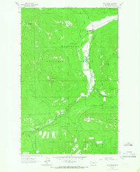
 1951 Clark Fork1952 Print · USGSThe Idaho-Montana borderlands are captured here in the early 1950s just as the river valley was preparing for major hydroelectric changes. Researchers can trace the legacy of local mining at Whitedelf Mine or locate early school sites like the River Echo Sch (Aband).4 unique versions available
 - 1951 Map of Mt Pend Oreille, 1952 Print
 1951 Mt Pend Oreille1952 Print · USGSThe Cabinet Mountains along the Idaho-Montana border are shown here in the early fifties, detailing a wilderness of forest lookouts and isolated mining claims. Researchers can find backcountry outposts like Smith Cabin and the Auxor Mine, along with numerous alpine waters such as Lake Estelle.4 unique versions available
 - 1956 Map of Wallace, 1966 Print
 1956 Wallace1966 Print · USGSWestern Montana and the Idaho panhandle meet in this mid-century survey of the Bitterroot and Cabinet Mountains. Genealogists and historians can trace the rail-and-river economy through the Northern Pacific line and settlements like Thompson Falls or St. Ignatius.3 unique versions available
 - 1957 Map of Kalispell, 1967 Print
 1957 Kalispell1967 Print · USGSNorthwest Montana in the late fifties showcases a mountain landscape transitioning between wilderness and industry. Genealogists and researchers can trace the Great Northern rail corridor through Kalispell and Whitefish, or locate landmarks like the Montana Soldiers Home and Hungry Horse Reservoir.3 unique versions available
 - 1958 Map of Sandpoint, 1966 Print
 1958 Sandpoint1966 Print · USGSThe Idaho Panhandle and Northeast Washington are shown here in the late fifties, when timber and hydroelectric power drove the local economy. Trace family roots in rail-side towns like Cusick or Metaline Falls, and locate landmarks like the Albeni Falls Dam or Falls Ranger Station.2 unique versions available
 - 1960 Map of Kalispell
 1960 Kalispell1960 Print · USGSNorthwest Montana in the late fifties is defined by the mountain corridors of the Great Northern Railway and the vast reaches of Glacier National Park. Researchers can trace the legacy of timber and mining towns like Libby, Rexford, and Whitefish, or locate landmarks such as the Snowshoe Mine.
 - 1960 Map of Wallace
 1960 Wallace1960 Print · USGSNorthwestern Montana and the Idaho panhandle are captured in the late fifties, showing the vast Flathead Indian Reservation and the mining districts of the Bitterroot Range. Researchers can trace the rail lines of the Northern Pacific or locate early sites like the Morning Mine and the National Bison Range.
 - 1961 Map of Kalispell
 1961 Kalispell1961 Print · USGSNorthwestern Montana at the start of the 1960s shows a landscape of timber-driven rail towns and the sprawling wild lands of Glacier National Park. Genealogists and historians can trace the route of the Great Northern through mountain passes or locate old settlements like Fortine, Trego, and Warland.
 - 1963 Map of Sandpoint
 1963 Sandpoint1963 Print · USGSNorthern Idaho and eastern Washington are shown in the early sixties as a high-country network of timber, mining, and rail. Genealogists and historians can trace the Great Northern line through Metaline Falls, Bonners Ferry, and past the Finch Mine.
 - 1963 Map of Wolf Prairie, 1965 Print
 1963 Wolf Prairie1965 Print · USGSKootenai National Forest in the early sixties is a landscape of mountain peaks and remote ranching outposts. Researchers can trace the legacy of land use through the French 8 Ranch, Fairview Guard Station, and the primitive Pack Trail winding past Sugarloaf Mountain.2 unique versions available
 - 1963 Map of Yaak, 1966 Print
 1963 Yaak1966 Print · USGSThe remote Montana interior comes into focus during the early sixties, centered on the river bend settlement of Yaak. Genealogists and historians can trace the foundations of this mountain community through the Yaak Sch, local Cem, and prospects scattered near Hensley Hill.
Showing maps 1-25 of 720
Top cities of Lincoln County
- Libby historical maps
- Eureka historical maps
- Troy historical maps
- Trego historical maps
- Fortine historical maps
- Rexford historical maps
See more
Frequently asked questions
- What are the different types of historical maps available for Lincoln County?
- What is the oldest map of Lincoln County?
- Where can I purchase historical maps of Lincoln County for my home or office?
- Where can I download high-res historical maps of Lincoln County?
- Are there historical topographic maps available for Lincoln County?
- Is there historical aerial imagery available for Lincoln County?
- Where are historical maps of Lincoln County sourced from?