1900s (20th Century) Maps of Eureka, Montana
Explore 8 historic maps of Eureka from the 1900s (20th Century). These maps offer a rare glimpse into what life looked like during the 1900s — showing old roads, neighborhoods, homes, and landmarks that have changed or disappeared over time.
Whether you're researching your family's past, planning a metal detecting trip, or studying how Eureka's landscape evolved across the 1900s, these high-resolution maps are a powerful tool for exploring the history of this region.
- Focus on a specific era: All maps on this page are from the 1900s, giving you a focused view of this time period.
- See what’s changed: Compare century-old streets, trails, and buildings to today's modern landscape using overlays and satellite layers.
- Research with precision: Use these maps for genealogy, historical research, land use analysis, or educational projects.
- View, download, or print: Maps are fully viewable online in high resolution, and can be downloaded or printed for your own records.
Start exploring Eureka's history through authentic maps from the 1900s. This is your window into the past.
Eureka, MT maps
(8)- 1957 Map of Kalispell, 1967 Print
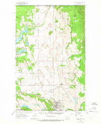
 1957 Kalispell1967 Print · USGSNorthwest Montana in the late fifties showcases a mountain landscape transitioning between wilderness and industry. Genealogists and researchers can trace the Great Northern rail corridor through Kalispell and Whitefish, or locate landmarks like the Montana Soldiers Home and Hungry Horse Reservoir.3 unique versions available
 - 1960 Map of Kalispell
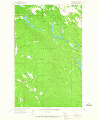
 1960 Kalispell1960 Print · USGSNorthwest Montana in the late fifties is defined by the mountain corridors of the Great Northern Railway and the vast reaches of Glacier National Park. Researchers can trace the legacy of timber and mining towns like Libby, Rexford, and Whitefish, or locate landmarks such as the Snowshoe Mine.
 - 1961 Map of Kalispell
 1961 Kalispell1961 Print · USGSNorthwestern Montana at the start of the 1960s shows a landscape of timber-driven rail towns and the sprawling wild lands of Glacier National Park. Genealogists and historians can trace the route of the Great Northern through mountain passes or locate old settlements like Fortine, Trego, and Warland.
 - 1963 Map of Eureka North, 1966 Print
 1963 Eureka North1966 Print · USGSThe international border at Roosville and the agricultural reaches of the Tobacco Plains are captured in the early sixties. Researchers can trace the Great Northern rail line, locate the Eureka Cemetery, and find old school sites like Iowa Flats School.3 unique versions available
 - 1963 Map of Eureka South, 1966 Print
 1963 Eureka South1966 Print · USGSLincoln County’s timber and rail country is captured here in the early sixties as the Great Northern tracks follow the Tobacco River through Eureka. Researchers can trace old forest routes and landmarks like the Black Butte Lookout Tower and Thirsty Lake.3 unique versions available
 - 1979 Map of Yaak River, 1993 Print
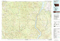 1979 Yaak River1993 Print · USGSThe Purcell and Salish Mountains define this corner of Northwest Montana in the late seventies. Researchers can trace remote fire lookouts like Lookout Tower Webb Mountain or study rail towns like Eureka and Rexford along the Burlington Northern.
 - 1997 Map of Eureka South, 2000 Print
 1997 Eureka South2000 Print · USGSThe southern edge of the Eureka community and the surrounding Kootenai forestlands are documented here in the late 1990s. Local researchers can trace family landmarks and high-country vantage points like Black Butte Lookout, Virginia Hill, and the winding Tobacco River.
 - 1997 Map of Eureka North, 2000 Print
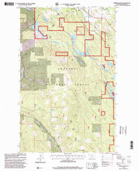
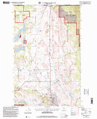 1997 Eureka North2000 Print · USGSThe Montana borderlands near Eureka come into focus during the late 1990s, where the Tobacco River meets the Kootenai National Forest. Researchers can trace the international crossing at Roosville, locate the old Iowa Flats School, and find family names near Eureka Cem.
End of results
Showing maps 1-8 of 8
Top cities near Eureka
Frequently asked questions
- What are the different types of historical maps available for Eureka?
- What is the oldest map of Eureka?
- Where can I purchase historical maps of Eureka for my home or office?
- Where can I download high-res historical maps of Eureka?
- Are there historical topographic maps available for Eureka?
- Is there historical aerial imagery available for Eureka?
- Where are historical maps of Eureka sourced from?