2000-2009 Maps of Madison County, Montana
Explore 14 historic maps of Madison County from 2000-2009. These maps offer a rare glimpse into what life looked like during the 2000s — showing old roads, neighborhoods, homes, and landmarks that have changed or disappeared over time.
Whether you're researching your family's past, planning a metal detecting trip, or studying how Madison County's landscape evolved across the 2000s, these high-resolution maps are a powerful tool for exploring the history of this region.
- Focus on a specific era: All maps on this page are from the 2000s, giving you a focused view of this time period.
- See what’s changed: Compare century-old streets, trails, and buildings to today's modern landscape using overlays and satellite layers.
- Research with precision: Use these maps for genealogy, historical research, land use analysis, or educational projects.
- View, download, or print: Maps are fully viewable online in high resolution, and can be downloaded or printed for your own records.
Start exploring Madison County's history through authentic maps from the 2000s. This is your window into the past.
Madison County, MT maps
(14)- 2000 Map of Beacon Point, 2005 Print
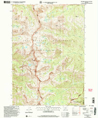
 2000 Beacon Point2005 Print · USGSGallatin County high country is mapped in detail during the late twentieth century, showing the intersection of wilderness and national forest management. Researchers can trace the alpine terrain of the Spanish Peaks, the waters of Grayling Lake, and the course of the Gallatin River.
 - 2000 Map of Ruby Mountain, 2005 Print
 2000 Ruby Mountain2005 Print · USGSGallatin and Madison counties at the turn of the millennium were defined by rugged forest management and mineral extraction. Geologists and local historians can trace mining activity at the Corundum Mine and explore the complex drainage of Maryott Gulch and Spanish Creek.
 - 2000 Map of Pika Point, 2005 Print
 2000 Pika Point2005 Print · USGSHigh in the Gallatin Range at the start of the century, this survey tracks the intersection of wilderness management and resource exploration. Researchers can locate the Beaver Creek Ranger Station, a dry oil well near Donna Lake, and the expansive Earthquake Area.
 - 2000 Map of Hilgard Peak, 2005 Print
 2000 Hilgard Peak2005 Print · USGSMadison and Gallatin counties are mapped here at the turn of the millennium, showing the protected reaches of the Lee Metcalf Wilderness. Researchers can trace the high-country drainages of Wolf Creek and locate remote alpine landmarks like Expedition Pass and Hilgard Peak.
 - 2000 Map of Willow Swamp, 2005 Print
 2000 Willow Swamp2005 Print · USGSThe Madison Range high country is captured here during the turn of the millennium, showing the protected wilderness of the Spanish Peaks. Hikers and researchers can trace the alpine drainage systems from Pioneer Falls to secluded backcountry waters like Chiquita Lake and Lake Solitude.
 - 2000 Map of Lincoln Mountain, 2005 Print
 2000 Lincoln Mountain2005 Print · USGSThe Madison Range wilderness is captured here at the turn of the millennium, showing a high-country landscape of forest and wildlife management areas. Researchers can locate remote landmarks like the Nine Quarter Circle Ranch, the high-altitude Albino Lake, and the isolated Landing Strip.
 - 2000 Map of Koch Peak, 2005 Print
 2000 Koch Peak2005 Print · USGSThe high Madison Range is captured here at the turn of the century, showcasing a primitive landscape of the Beaverhead and Gallatin forests. Hikers and researchers can trace drainage systems from Koch Peak down to Tumbledown Falls and Snake Lake.
 - 2000 Map of Bear Trap Creek, 2005 Print
 2000 Bear Trap Creek2005 Print · USGSThe Madison River canyon and the surrounding Gallatin National Forest appear in fine detail during the late nineties. Local researchers can trace old mining sites like Mine Shaft Spring, various unnamed Prospects, and the location of the Cherry Creek School.
 - 2000 Map of Ousel Falls, 2005 Print
 2000 Ousel Falls2005 Print · USGSGallatin County’s high country is captured here at the turn of the millennium, showing a landscape defined by wilderness boundaries and river forks. Researchers can trace remote mountain infrastructure and landmarks like Cinnamon Lookout, Ousel Falls, and various Prospects.
 - 2000 Map of Targhee Peak, 2005 Print
 2000 Targhee Peak2005 Print · USGSThe high mountain border between Idaho and Montana is captured here at the turn of the millennium, centered on the northern reaches of Henrys Lake. Genealogists and historians can locate legacy properties like the Wild Rose Ranch and Staley Springs along the rugged Continental Divide.
 - 2000 Map of Cherry Creek Canyon, 2005 Print
 2000 Cherry Creek Canyon2005 Print · USGSMadison County ranching and forest lands are detailed here at the turn of the century. Trace historic high-country outposts like Butler Ranch, old mining Prospects, and irrigation works such as Butler Ditch.
 - 2000 Map of Earthquake Lake, 2005 Print
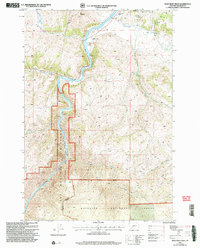
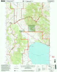
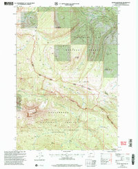
 2000 Earthquake Lake2005 Print · USGSThe Madison River valley was a landscape in transition at the turn of the millennium, defined by its massive mid-century landslide. Researchers can trace family ranching sites like Olifee Ranch alongside more modern developments like the Earthquake Memorial.
 - 2001 Map of Stonehouse Mountain, 2004 Print
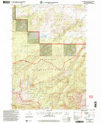
 2001 Stonehouse Mountain2004 Print · USGSMadison County high country is shown here at the turn of the 21st century, where industrial history meets federal wilderness. Trace the footprints of early prospectors at Copper Camp or find the remote waters of Upper Copper Lake and Copper Lake.
 - 2005 Map of Sphinx Mountain
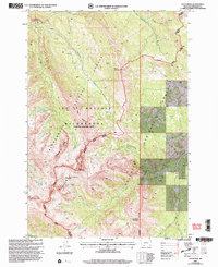
 2005 Sphinx Mountain2005 Print · USGSMadison County at the turn of the millennium was a landscape of high wilderness and forest service outposts. Researchers can trace remote sites like Marley Camp, the Yellow Mule Ranger Station, and the crossing at Indian Crossing.
End of results
Showing maps 1-14 of 14
Top cities of Madison County
- Ennis historical maps
- Sheridan historical maps
- Twin Bridges historical maps
- Virginia City historical maps
- Harrison historical maps
Frequently asked questions
- What are the different types of historical maps available for Madison County?
- What is the oldest map of Madison County?
- Where can I purchase historical maps of Madison County for my home or office?
- Where can I download high-res historical maps of Madison County?
- Are there historical topographic maps available for Madison County?
- Is there historical aerial imagery available for Madison County?
- Where are historical maps of Madison County sourced from?