Old Maps of Madison County, Montana for Genealogy
Trace your family roots with 666 historic maps of Madison County. These high-res maps reveal old neighborhoods, homesites, landmarks, and streets — helping you uncover where your ancestors lived and how the area evolved over time.
- Explore historic neighborhoods: Identify where your relatives may have lived in the 1800s or 1900s.
- Compare maps over time: Trace the changes in streets, buildings, and landmarks for multi-generational research.
- Perfect for genealogy & ancestry research: Used by family historians and researchers to map out lineage and migration.
These maps are an incredible resource for exploring your personal connection to Madison County's past.
Madison County, MT maps
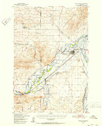
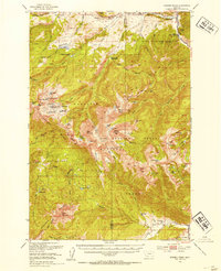
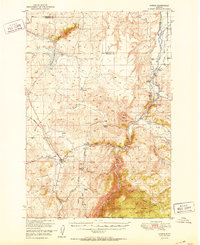
(666)- 1888 Map of Three Forks
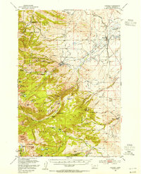
 1888 Three Forks1888 Print · USGSSouthwestern Montana was a land of mining camps and river junctions in the late nineteenth century, as the railroad began to connect established valleys. Genealogists can trace family roots through pioneer settlements like Virginia City, Salesville, and Spring Hill, or locate early crossings at Barton's Bridge.
 - 1893 Map of Dillon
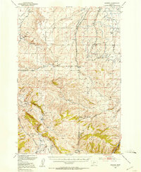
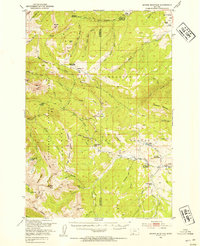
 1893 Dillon1893 Print · USGSSouthwestern Montana’s mountain ranges and river basins were being reshaped by the mining and rail boom in the late nineteenth century. Genealogists and historians can trace the early layout of Dillon and vanished camps like Hecla, Rochester, and Argenta.5 unique versions available
 - 1894 Map of Three Forks
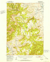
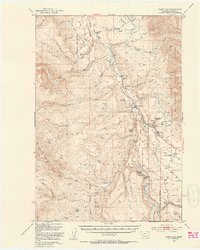
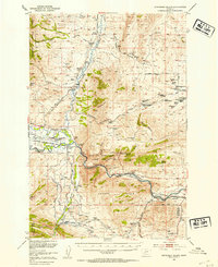
 1894 Three Forks1894 Print · USGSSouthwestern Montana thrives along the river forks and rail lines during the mid-1880s. Genealogists and historians can trace early town sites like Pony, Logan, and Salesville while locating river crossings such as Fly's Bridge and Shedds Bridge.
 - 1895 Map of Three Forks
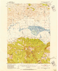
 1895 Three Forks1895 Print · USGSSouthern Montana was a landscape of emerging rail towns and gold-country gulches during the mid-1890s. Genealogists and historians can trace the early footprints of Bozeman, locate Guns Ranch, and follow the Northern Pacific Railroad through Three Forks.5 unique versions available
 - 1947 Map of Bozeman, 1948 Print
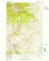
 1947 Bozeman1948 Print · USGSBozeman and the surrounding mountain ranges are captured here just after the war, showing the vital rail and river networks of southwestern Montana. Genealogists and historians can trace routes to early settlements like Virginia City, Gallatin Gateway, and the mountain community of Jardine.
 - 1948 Map of Bozeman, 1951 Print
 1948 Bozeman1951 Print · USGSSouthern Montana in the late 1940s is shown as a high-country crossroads of rail lines and river headwaters. Genealogists and historians can trace old town sites like Virginia City and McLeod alongside the Northern Pacific and Milwaukee Road railroads.
 - 1949 Map of Varney, 1952 Print
 1949 Varney1952 Print · USGSMadison County ranching and high-altitude mining define this post-war landscape as it transitioned into modern land management. Researchers can trace historic mineral claims like the Marietta Mine and Summit Mine or locate family ranch holdings including the Rankin Ranch and Hudson Ranch.3 unique versions available
 - 1949 Map of Anceney, 1953 Print
 1949 Anceney1953 Print · USGSGallatin County ranching and irrigation are recorded in detail here at the close of the 1940s. Genealogists and historians can locate old landmarks like the Little Holland Cemetery, the Corundum Mine, and the Northern Pacific rail line serving the Anceney settlement.4 unique versions available
 - 1949 Map of Ennis, 1954 Print
 1949 Ennis1954 Print · USGSMadison County's ranching and river heritage is preserved here in the late 1940s, centered on the community of Ennis. Genealogists and historians can locate specific family holdings like Shelhamer Ranch, the Ennis Cent church, and the Harris Inn Landing Field.11 unique versions available
 - 1949 Map of Norris, 1959 Print
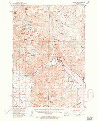
 1949 Norris1959 Print · USGSMadison and Gallatin counties met at the river in the post-war years, where high-country ranching and mining legacies shaped the land. Researchers can locate the Red Bluff Cem, inactive gold-era sites like Boaz Mine, and the Cherry Creek School.2 unique versions available
 - 1950 Map of Three Forks, 1953 Print
 1950 Three Forks1953 Print · USGSThree Forks and the surrounding Gallatin Valley are captured here just after the war, showing the historic meeting of the rivers that form the Missouri. Genealogists and historians can trace the foundations of this ranching community through the Jefferson Sch, Fairview Cem, and the Climbing Arrow Ranch.4 unique versions available
 - 1950 Map of Cliff Lake, 1953 Print
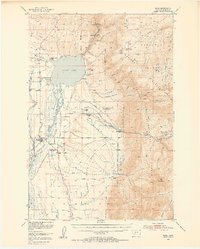
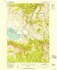
 1950 Cliff Lake1953 Print · USGSMadison County rangeland and the upper Madison River basin come into focus just after the war. Researchers can trace historic homesteads and sportsmen's retreats such as Snowball Inn, Wickadahl Ranch, and Miller Cow Camp.6 unique versions available
 - 1950 Map of Hebgen Dam, 1954 Print
 1950 Hebgen Dam1954 Print · USGSThe Madison Range and the high country of the Montana-Idaho border come alive in this mid-century survey. You can trace the ranching and early tourism of the era through sites like Olifee Ranch, Campfire Lodge, and the remote Watkins Creek Ranch airstrip.7 unique versions available
 - 1950 Map of Cameron, 1954 Print
 1950 Cameron1954 Print · USGSMadison County ranching and mountain mining are captured here in the mid-twentieth century. Researchers can trace family ranch boundaries like Storey Ranch and Armitage Ranch or locate historical operations at Ruby Mine and Krauss Sawmill.5 unique versions available
 - 1950 Map of Spanish Peaks, 1954 Print
 1950 Spanish Peaks1954 Print · USGSThe Madison Range high country comes into focus in this early 1950s survey of the Gallatin and Beaverhead National Forests. Researchers can locate remote mountain landmarks and early ranch sites like 8K Ranch, Crall Ranch, and the Spanish Creek Ranger Station.4 unique versions available
 - 1950 Map of Sphinx Mountain, 1954 Print
 1950 Sphinx Mountain1954 Print · USGSThe high peaks of Madison County and Gallatin County are mapped here in the early postwar era, capturing a landscape of remote ranger stations and historic family ranches. Researchers can locate early forest outposts like Yellow Mule Ranger Sta or trace old backcountry routes such as the Wapiti Trail and Eldridge Trail.4 unique versions available
 - 1950 Map of Jefferson Island, 1954 Print
 1950 Jefferson Island1954 Print · USGSThe Jefferson River valley in the early 1950s reveals a landscape of industrial rail lines and established family ranchlands. Genealogists and local historians can locate early homesteads like Tribble Ranch, the Eureka School, and the South Boulder Cemetery.4 unique versions available
 - 1950 Map of Lower Red Rock Lake, 1954 Print
 1950 Lower Red Rock Lake1954 Print · USGSThe high Centennial Valley comes to life in the early fifties, where ranching and conservation meet along the Continental Divide. Genealogists and historians can trace family locations like the Goble Ranch, the Doyle School, and the remote Landon Camp.5 unique versions available
 - 1950 Map of Harrison, 1954 Print
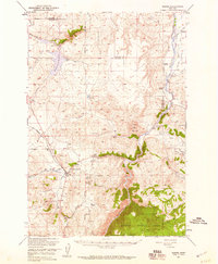
 1950 Harrison1954 Print · USGSMadison County's mining and ranching history is captured here in the mid-century, from the high peaks to the rail lines. Trace old mining operations like the Boss Tweed Mine, visit the Potosi Hot Springs, or locate the Sterling (Aban'd) townsite.5 unique versions available
 - 1950 Map of Virginia City, 1954 Print
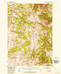
 1950 Virginia City1954 Print · USGSMadison County mining history is preserved here during the early fifties, detailing the rugged terrain of the Tobacco Root Mountains. Genealogists and historians can trace family claims at the Nine Grant Mines, find the local Cem, or locate the South Meadow Creek Ranger Station.5 unique versions available
 - 1950 Map of Monument Ridge, 1954 Print
 1950 Monument Ridge1954 Print · USGSThe high basins of the Madison and Beaverhead counties border come alive in the mid-1950s, showing a landscape of forest service stations and seasonal camps. Genealogists and historians can locate remote outposts like Three Forks Cow Camp and the Black Butte Ranger Station or trace the early Standard Creek Road.4 unique versions available
 - 1950 Map of Upper Red Rock Lake, 1954 Print
 1950 Upper Red Rock Lake1954 Print · USGSThe Centennial Valley and the Continental Divide are documented here in the early fifties, featuring the expansive Upper Red Rock Lake. Researchers can trace old family holdings like the Hanson Ranch and Cook Sheep Ranch or locate the Selby Resort and early forest campgrounds.3 unique versions available
 - 1951 Map of Norris
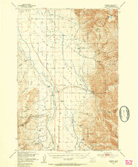
 1951 Norris1951 Print · USGSThe Madison River valley was a hub of irrigation and mining just after the war. Genealogists can locate family holdings like Noble Ranch or Barter Ranch and trace the paths of the Northern Pacific and Cherry Creek School.2 unique versions available
 - 1955 Map of Bozeman
 1955 Bozeman1955 Print · USGSBozeman and the upper Missouri River headwaters are captured here during the mid-fifties, showing the vital rail and river networks of southwestern Montana. Local historians can trace the routes of the Northern Pacific railroad through Livingston and locate smaller settlements like Trident, Anceney, and Jardine.
 - 1955 Map of Dubois
 1955 Dubois1955 Print · USGSThe high desert and mountain passes of eastern Idaho and western Montana are captured here during the mid-fifties. Researchers can trace the Union Pacific rail line through Dubois or locate the National Reactor Testing Station.4 unique versions available
Showing maps 1-25 of 666
Top cities of Madison County
- Ennis historical maps
- Sheridan historical maps
- Twin Bridges historical maps
- Virginia City historical maps
- Harrison historical maps
Frequently asked questions
- What are the different types of historical maps available for Madison County?
- What is the oldest map of Madison County?
- Where can I purchase historical maps of Madison County for my home or office?
- Where can I download high-res historical maps of Madison County?
- Are there historical topographic maps available for Madison County?
- Is there historical aerial imagery available for Madison County?
- Where are historical maps of Madison County sourced from?