1980s Maps of Madison County, Montana
Explore 65 historic maps of Madison County from the 1980s. These maps offer a rare glimpse into what life looked like during the 1980s — showing old roads, neighborhoods, homes, and landmarks that have changed or disappeared over time.
Whether you're researching your family's past, planning a metal detecting trip, or studying how Madison County's landscape evolved across the 1980s, these high-resolution maps are a powerful tool for exploring the history of this region.
- Focus on a specific era: All maps on this page are from the 1980s, giving you a focused view of this time period.
- See what’s changed: Compare century-old streets, trails, and buildings to today's modern landscape using overlays and satellite layers.
- Research with precision: Use these maps for genealogy, historical research, land use analysis, or educational projects.
- View, download, or print: Maps are fully viewable online in high resolution, and can be downloaded or printed for your own records.
Start exploring Madison County's history through authentic maps from the 1980s. This is your window into the past.
Madison County, MT maps
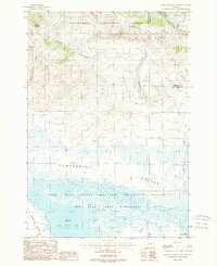
(65)- 1983 Map of Dillon
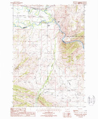
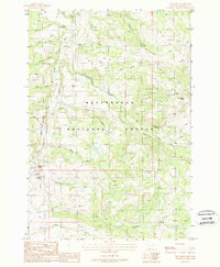
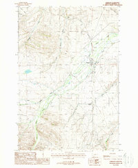
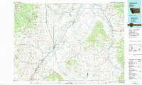 1983 Dillon1983 Print · USGSSouthwestern Montana’s ranching and mining heritage is recorded here in the early eighties, centered on the growing hub of Dillon. Researchers can trace the legacy of early gold strikes at Bannack or locate legacy claims like the Silver Bell Mine and Legal Tender Mine.
 - 1987 Map of Lima
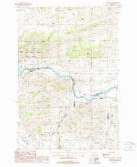
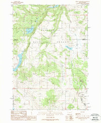
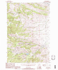
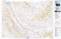 1987 Lima1987 Print · USGSThe high mountain passes of the Montana-Idaho border come alive in the late eighties as they follow the historic rail and road corridors. You can trace the Union Pacific line through Lima and Monida or locate the Silver Queen Mine in the northern ranges.
 - 1987 Map of Madison Plateau
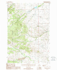
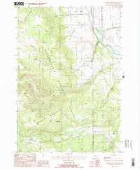
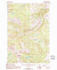
 1987 Madison Plateau1987 Print · USGSHigh-altitude ranching and irrigation systems define this Montana landscape in the late eighties. Researchers can trace historical water management through the Hutchison Ditch and find livestock landmarks like the Feed Lot and Willow Springs.
 - 1987 Map of Maltbys Mound, 1988 Print
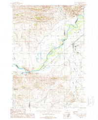
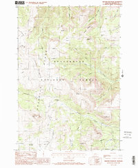
 1987 Maltbys Mound1988 Print · USGSMadison County mining and mountain peaks are captured here in the late eighties. Researchers can trace the legacy of mineral extraction through the Revenue Mine, Galena Mine, and Sterling settlement, while identifying high-country landmarks like Sugarloaf Mountain.
 - 1987 Map of Willow Creek, 1988 Print
 1987 Willow Creek1988 Print · USGSGallatin County's river valleys and irrigation networks are shown in detail during the late 1980s. Researchers can locate landmarks like the Stateler Monument, the Ingleside Quarry, and local family-named water features like the Buttleman Ditch.
 - 1987 Map of Jefferson Island, 1988 Print
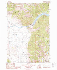
 1987 Jefferson Island1988 Print · USGSMadison and Jefferson counties meet along the river in the late 1980s as the rail and mining sectors define the local landscape. Genealogists and historians can trace industrial roots at the Mayflower Mine or locate early settlements like Jefferson Island and Cardwell.
 - 1987 Map of Sappington, 1988 Print
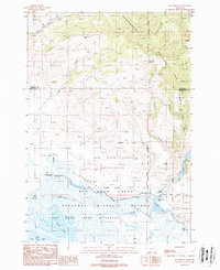
 1987 Sappington1988 Print · USGSNear the three-county junction of Jefferson, Madison, and Gallatin in the late 1980s, this landscape shows a crossroads of rail and river history. Trace the Burlington Northern line past Sappington or locate the various Mines Shafts Prospects and the Cem near the river bend.
 - 1987 Map of Ruby Mountain, 1988 Print
 1987 Ruby Mountain1988 Print · USGSThe Madison and Gallatin county border was a site of quiet mineral exploration and forest management in the late eighties. Researchers can locate specific sites of historical prospecting like the Mine Shaft near Maryott Creek and trace the rugged Spanish Breaks above the Gallatin River.
 - 1987 Map of Norris NE, 1988 Print
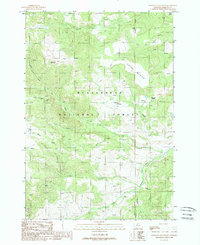
 1987 Norris NE1988 Print · USGSThe Madison Valley is captured in the late 1980s, showing the intricate relationship between the river and the surrounding high country. Local historians can trace early water rights through infrastructure like Hutchison Ditch and Nobles Ditch near Red Mountain.
 - 1988 Map of Granite Mountain
 1988 Granite Mountain1988 Print · USGSMadison County, Montana, at the edge of the 1990s reveals a high-country wilderness defined by the Madison River valley. Researchers can trace historical access routes like the Wall Creek Pack Trail or locate mining prospects near Gold Butte.2 unique versions available
 - 1988 Map of Bighorn Mountain
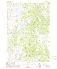
 1988 Bighorn Mountain1988 Print · USGSHigh in the Madison County mountains during the late 1980s, this area shows a landscape used by ranchers and foresters alike. Researchers can locate remote outposts like the Black Butte Cabin, trace the Gravelly Range Road, or find the Redish Sheep Headquarters.2 unique versions available
 - 1988 Map of Hidden Lake Bench
 1988 Hidden Lake Bench1988 Print · USGSThe Montana-Idaho border highlands are captured here in the late eighties, featuring the remote wilderness of the Beaverhead National Forest. Researchers can trace the high-country Continental Divide and locate sites like Lost Mine or the waters of Elk Lake.
 - 1988 Map of Eureka Basin
 1988 Eureka Basin1988 Print · USGSIn the late 1980s, the high country of Madison County was a landscape of remote watersheds and forest management. Researchers can trace land use through features like the West Fork FS Station, the Gravelly Range Road, and an old Mine Shaft.2 unique versions available
 - 1988 Map of Willow Creek Reservoir
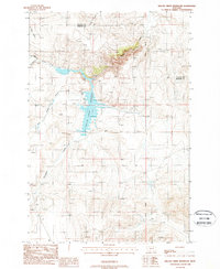 1988 Willow Creek Reservoir1988 Print · USGSMadison and Gallatin counties met at this high-country reservoir in the late eighties. Genealogists and outdoor historians can trace the course of Willow Creek, find the remote Prospects, or locate the Boat Ramp and Picnic Area on the water's edge.
 - 1988 Map of Freezeout Mountain
 1988 Freezeout Mountain1988 Print · USGSMadison County high country in the late 1980s reveals a landscape of high summits and seasonal grazing camps within the Beaverhead National Forest. Trace family ranching history near Sloan Cow Camp or explore the alpine drainages of Freezeout Mountain and Lobo Mesa.
 - 1988 Map of Iron Creek
 1988 Iron Creek1988 Print · USGSMadison County high country is documented here in the late 1980s, showcasing a landscape of national forest land and vital mountain springs. Researchers can trace historic grazing sites like Three Forks Cow Camp and landmarks such as Strawberry Butte and the Ruby River.
 - 1988 Map of Pony
 1988 Pony1988 Print · USGSMadison County mining history and the Tobacco Root Mountains are captured here during the late twentieth century. Researchers can trace the extensive network of tunnels and claims including the Boss Tweed Mine, Pony Mine, and the Indiana University Geology Field Station.
 - 1988 Map of Bear Trap Creek
 1988 Bear Trap Creek1988 Print · USGSThe Madison River valley in the late eighties shows a landscape preserved by the Lee Metcalf Wilderness and the Gallatin National Forest. You can trace historical resource extraction through numerous Mine Shafts and Prospects scattered among the drainages of Bear Trap Creek and Cherry Creek.
 - 1988 Map of Potosi Peak
 1988 Potosi Peak1988 Print · USGSMadison County high country is shown in detail during the late twentieth century as it appeared within the Beaverhead National Forest. Historians and hikers can trace old mining sites like Beulah Mine or locate secluded alpine waters such as Lady of the Lake and Hollow Top Lake.2 unique versions available
 - 1988 Map of Lower Red Rock Lake
 1988 Lower Red Rock Lake1988 Print · USGSThe Centennial Valley of southwestern Montana is captured here in the late eighties as a preserved wilderness of wetlands and high ridges. Researchers can trace the boundaries of the Red Rock Lakes Wilderness and find natural features like Patchtop Mountain and Sparrow Slough.
 - 1988 Map of Earthquake Lake
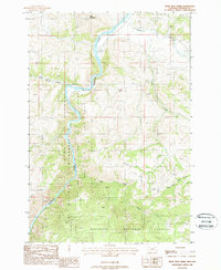
 1988 Earthquake Lake1988 Print · USGSThe Madison River valley in the late 1980s reveals the permanent geological changes following the 1959 earthquake. Researchers can locate the massive Madison Slide and Earthquake Lake, as well as the Earthquake Memorial and a high-altitude Quarry.
 - 1988 Map of Anceney
 1988 Anceney1988 Print · USGSGallatin and Madison counties meet here in the late 1980s, revealing an intricate world of high-plains ranching and irrigation. Family historians can trace the rural community around Church Hill and find landmarks like Anceney or the Highline Canal.
 - 1988 Map of Elk Springs
 1988 Elk Springs1988 Print · USGSThe Centennial Valley and Beaverhead Mountains define this 1980s landscape of high-country water and wildlife habitat. Researchers can trace land-use patterns through the Elk Springs Corral, a lookout tower, and an Open Pit Mine near Elk Lake.
 - 1988 Map of Windy Hill
 1988 Windy Hill1988 Print · USGSThe high backcountry of Madison County comes into focus in the late 1980s, showcasing the timbered slopes and ridges of the Beaverhead National Forest. Researchers can trace the winding paths of the Elk River and Madison River, or locate remote points like Wolverine Basin and Divide Mountain.
 - 1988 Map of Harrison
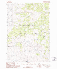
 1988 Harrison1988 Print · USGSMadison County ranching and rail infrastructure define this area during the late eighties. Genealogists and local historians can trace irrigation networks like the Missouri Ditch and industrial remnants such as the Tailings near Norwegian Creek.
Showing maps 1-25 of 65
Top cities of Madison County
- Ennis historical maps
- Sheridan historical maps
- Twin Bridges historical maps
- Virginia City historical maps
- Harrison historical maps
Frequently asked questions
- What are the different types of historical maps available for Madison County?
- What is the oldest map of Madison County?
- Where can I purchase historical maps of Madison County for my home or office?
- Where can I download high-res historical maps of Madison County?
- Are there historical topographic maps available for Madison County?
- Is there historical aerial imagery available for Madison County?
- Where are historical maps of Madison County sourced from?