1930s Maps of Sanders County, Montana
Explore 8 historic maps of Sanders County from the 1930s. These maps offer a rare glimpse into what life looked like during the 1930s — showing old roads, neighborhoods, homes, and landmarks that have changed or disappeared over time.
Whether you're researching your family's past, planning a metal detecting trip, or studying how Sanders County's landscape evolved across the 1930s, these high-resolution maps are a powerful tool for exploring the history of this region.
- Focus on a specific era: All maps on this page are from the 1930s, giving you a focused view of this time period.
- See what’s changed: Compare century-old streets, trails, and buildings to today's modern landscape using overlays and satellite layers.
- Research with precision: Use these maps for genealogy, historical research, land use analysis, or educational projects.
- View, download, or print: Maps are fully viewable online in high resolution, and can be downloaded or printed for your own records.
Start exploring Sanders County's history through authentic maps from the 1930s. This is your window into the past.
Sanders County, MT maps
(8)- 1930 Map of Libby, 1960 Print
 1930 Libby1960 Print · USGSNorthwestern Montana at the opening of the 1930s is a rugged domain of mountain mining and timber camps. Genealogists and researchers can trace early settlers through labels like Old Town, Bull Lake Sch, and high-country operations such as the Snowshoe Mine.
 - 1932 Map of Libby
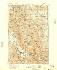
 1932 Libby1932 Print · USGSThe Kootenai River valley and surrounding mountain ranges are captured here in the early 1930s during the height of the region's mining and timber era. Genealogists and historians can locate remote landmarks like Old Town, the Snowshoe Mine, and early rural schools including Bull Lake Sch.3 unique versions available
 - 1932 Map of Trout Creek, 1955 Print
 1932 Trout Creek1955 Print · USGSThe Clark Fork River corridor in the 1930s shows a landscape of mountain rail travel and early forest management. Genealogists and historians can locate rural schools like Ayers School, local industry at Tuscor Mill, and old mining sites such as the Jack White Mine.
 - 1935 Map of Thompson Lakes
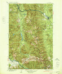
 1935 Thompson Lakes1935 Print · USGSNorthwestern Montana in the mid-thirties was a rugged domain of timber management and rail-line outposts. Researchers can trace the Great Northern Ry through Jennings or locate remote schools like the Thompson River Sch and Manicke Sch.3 unique versions available
 - 1935 Map of Trout Creek, 1949 Print
 1935 Trout Creek1949 Print · USGSThe Clark Fork valley and the mining districts of Shoshone County are caught in high detail in the 1930s. Genealogists and historians can trace rail-side schools like Tuscor Sch, the operations at Jack Waite Mine, and old settlements from Noxon to Mace.
 - 1936 Map of Trout Creek
 1936 Trout Creek1936 Print · USGSThe Clark Fork valley and the Bitterroot mountains are captured here in the mid-1930s, showing a landscape defined by timber and mining. Researchers can trace the industrial footprint of the Tuscor Mill, remote operations like the Jack Waite Mine, and old mountain schools such as Flat Sch.2 unique versions available
 - 1937 Map of Thompson Falls
 1937 Thompson Falls1937 Print · USGSThe Clark Fork river valley and the high Cabinet Mountains are documented here in the mid-1930s. Genealogists and researchers can trace the early railroad communities of Thompson Falls and Belknap or locate the Silver Butte Fisher Sch and Bend Ranger Sta.2 unique versions available
 - 1937 Map of Thompson Falls, 1949 Print
 1937 Thompson Falls1949 Print · USGSThe Clark Fork valley in the 1930s was a vital corridor defined by the Northern Pacific Line and riverside settlements. Researchers can trace early infrastructure and mountain life through the locations of the Silver Butte Fisher Sch, the Bend Ranger Sta, and the ferry at Eddy.
End of results
Showing maps 1-8 of 8
Top cities of Sanders County
- Thompson Falls historical maps
- Plains historical maps
- Hot Springs historical maps
- Trout Creek historical maps
- Noxon historical maps
- Paradise historical maps
Frequently asked questions
- What are the different types of historical maps available for Sanders County?
- What is the oldest map of Sanders County?
- Where can I purchase historical maps of Sanders County for my home or office?
- Where can I download high-res historical maps of Sanders County?
- Are there historical topographic maps available for Sanders County?
- Is there historical aerial imagery available for Sanders County?
- Where are historical maps of Sanders County sourced from?