1990s Maps of Sanders County, Montana
Explore 73 historic maps of Sanders County from the 1990s. These maps offer a rare glimpse into what life looked like during the 1990s — showing old roads, neighborhoods, homes, and landmarks that have changed or disappeared over time.
Whether you're researching your family's past, planning a metal detecting trip, or studying how Sanders County's landscape evolved across the 1990s, these high-resolution maps are a powerful tool for exploring the history of this region.
- Focus on a specific era: All maps on this page are from the 1990s, giving you a focused view of this time period.
- See what’s changed: Compare century-old streets, trails, and buildings to today's modern landscape using overlays and satellite layers.
- Research with precision: Use these maps for genealogy, historical research, land use analysis, or educational projects.
- View, download, or print: Maps are fully viewable online in high resolution, and can be downloaded or printed for your own records.
Start exploring Sanders County's history through authentic maps from the 1990s. This is your window into the past.
Sanders County, MT maps
(73)- 1992 Map of Thompson Falls, 1993 Print
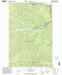
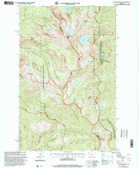
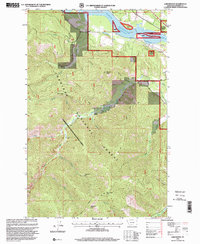
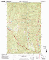
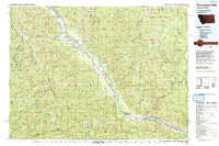 1992 Thompson Falls1993 Print · USGSNorthwest Montana in the early nineties is defined here by the winding Clark Fork and its major impoundments. Researchers can trace the river-valley settlements of Noxon, Trout Creek, and Thompson Falls or locate mining sites like the Copper King Mine.
 - 1994 Map of Wallace
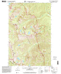
 1994 Wallace1994 Print · USGSThe Bitterroot Mountains and the mining heart of the Silver Valley are captured here in the mid-1990s. Researchers can locate active and historic mineral operations such as the Argentine Mine and Last Chance Mines, while tracing the Milwaukee Road through the high passes.
 - 1996 Map of Jordan Creek, 1999 Print
 1996 Jordan Creek1999 Print · USGSThe Bitterroot mountains and the Idaho-Montana state line meet here in the late twentieth century. Researchers can trace historic access routes like the National Recreation Trail and find landmarks such as Jordan Camp and Spion Kop Rock.
 - 1996 Map of Scotchman Peak, 1999 Print
 1996 Scotchman Peak1999 Print · USGSThe Cabinet Mountains wilderness comes alive in this late-1990s survey of the Idaho-Montana borderlands. Topographical researchers can trace the high ridges of Scotchman Peak and Goat Mountain or locate remote landmarks like the Open Pit Mine and Little Spar Lake.
 - 1996 Map of Taylor Peak, 1999 Print
 1996 Taylor Peak1999 Print · USGSThe high peaks of the Idaho-Montana border are captured here in the mid-1990s as the regional forest service network managed these remote reaches. Researchers can trace historic access points and seasonal sites like Berlin Flats, Hawksaye Camp, and the winding Berlin Gulch.
 - 1996 Map of Burke, 1999 Print
 1996 Burke1999 Print · USGSThe silver-rich Canyon Creek corridor of Shoshone County is shown here in the late nineties, documenting the dense footprint of Idaho's mining history. Genealogists and historians can trace the foundations of Burke, Mace, and Cornwall alongside major sites like the Hecla Mine and the Standard Mammoth Mine.
 - 1996 Map of Murray, 1999 Print
 1996 Murray1999 Print · USGSThe mining-scarred landscape around Murray is documented in the mid-1990s as it straddles the Idaho-Montana border. Genealogists and historians can trace old mining sites and landmarks like the Dredge tailings along Prichard Creek and Jack Waite Forks.
 - 1997 Map of Crowell Mountain, 2000 Print
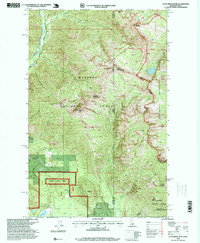
 1997 Crowell Mountain2000 Print · USGSWestern Montana's rugged timberlands and glacial lakes are captured here in the late nineties, documenting the area around Bull Lake. Researchers can locate old forest settlements like Dorr Skeels and Little Joe alongside the wild peaks of Gordon Mountain.
 - 1997 Map of Elephant Peak, 2000 Print
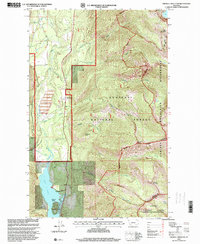
 1997 Elephant Peak2000 Print · USGSThe Cabinet Mountains wilderness of Sanders and Lincoln counties is shown here as it remained in the late twentieth century. Researchers can trace historic access routes like the OLD DALY TRAIL or locate the site of the Heidelberg Mine near Rock Creek Falls.
 - 1997 Map of Helwick Peak, 2000 Print
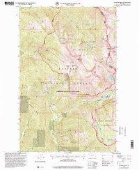
 1997 Helwick Peak2000 Print · USGSNorthwest Montana’s high timber country is captured here in the late nineties, showing the complex administrative borders of three national forests. Trace the steep drainages of White Pine Creek and Beaver Creek or locate the solitary Prospect near Helwick Peak.
 - 1997 Map of Miller Lake, 2000 Print
 1997 Miller Lake2000 Print · USGSThe high peaks of the Kootenai and Kaniksu National Forests define this corner of Montana in the late nineties. Researchers can trace remote alpine trails and water sources from Miller Lake and Sylvan Lake to summits like Owl Peak and Moose Peak.
 - 1997 Map of Trout Creek, 2000 Print
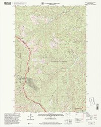
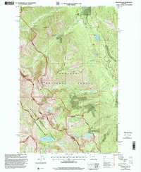
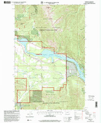
 1997 Trout Creek2000 Print · USGSThe Clark Fork valley in the late twentieth century is shown here as the Noxon Reservoir reaches its full extent. Researchers can locate the Whitepine Cem, trace the Water Hill Trail, and examine the shoreline near Trout Creek and Honey Flat.
 - 1997 Map of Seven Point Mountain, 2000 Print
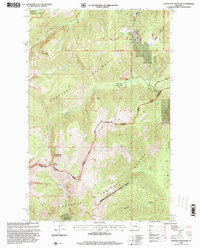
 1997 Seven Point Mountain2000 Print · USGSThe Sanders County backcountry in the late nineties is detailed here, where the mountain peaks of the Kaniksu and Lolo forests meet. Trace old routes like the Cataract Creek Trail or locate the small riverside settlement at Childs on the Clark Fork.
 - 1997 Map of Snowshoe Peak, 2000 Print
 1997 Snowshoe Peak2000 Print · USGSThe high Cabinet Mountains are captured here in the late nineties at the intersection of Lincoln and Sanders counties. Genealogists and researchers can trace the reach of the Snowshoe Mine, St Paul Mine, and the alpine shores of Leigh Lake and Granite Lake.
 - 1997 Map of Treasure Mountain, 2000 Print
 1997 Treasure Mountain2000 Print · USGSThe Cabinet Mountains wilderness in the late nineties is presented here in high-country detail, from the peaks of the Libby Ranger District to the Sanders County line. Researchers can trace historic extraction efforts at Mines and Prospects or locate high-altitude landmarks like Lake Osakis and Gus Brink Mountain.
 - 1997 Map of Black Peak, 2000 Print
 1997 Black Peak2000 Print · USGSThe high peaks and forest boundaries along the Idaho-Montana border are meticulously detailed in this late twentieth-century survey. Researchers and hikers can trace remote mining activity near the Duthie site, locate the Sex Peak Lookout, and explore the headwaters of Beaver Creek.
 - 1997 Map of Meadow Peak, 2000 Print
 1997 Meadow Peak2000 Print · USGSThe high timberlands of the Flathead and Sanders county line are documented here in the late nineties as part of the Forest Service system. Researchers can locate the Thompson River School and trace the Barium Summer Creek Trail near Meadow Peak Lookout.
 - 1997 Map of Larchwood, 2000 Print
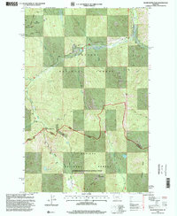
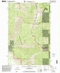
 1997 Larchwood2000 Print · USGSThe Clark Fork valley in the late 1990s reveals a landscape of high-country mining and timber lands surrounding the Noxon Reservoir. Researchers can trace the legacy of the Ambassador Mine or follow the National Recreation Trail past Larchwood.
 - 1997 Map of Howard Lake, 2000 Print
 1997 Howard Lake2000 Print · USGSThe Cabinet Mountains high country in the late nineties is a landscape of alpine basins and deep-seated mining history. Mineral hunters and hikers can trace the paths to the Midas Mine, American Kootenai Mine, and the waters of Wanless Lake.
 - 1997 Map of Sawtooth Mountain, 2000 Print
 1997 Sawtooth Mountain2000 Print · USGSNorthwest Montana in the 1990s reveals a landscape of industrial extraction and forest conservation near the Cabinet Mountains. Local historians can trace the legacy of the Asarco Mill, find the North Star Mine, and explore the ancient groves of the Ross Creek Cedars Scenic Area.
 - 1997 Map of Silver Butte Pass, 2000 Print
 1997 Silver Butte Pass2000 Print · USGSIn the late nineties, this mountainous region on the Lincoln and Sanders county line was a hub for backcountry resource management and mining. You can trace the rugged trails leading to the Viking Mine, locate Frog Lake, or follow the Fisher River through the heart of the forest.
 - 1997 Map of Vermilion Peak, 2000 Print
 1997 Vermilion Peak2000 Print · USGSThe high Montana backcountry of Sanders County is captured here in the late 1990s as it spans the border of two national forests. Trace the alpine drainage systems and primitive trails connecting Vermilion Peak, Rush Lake, and the Cabinet Thompson Falls route.
 - 1997 Map of Noxon Rapids Dam, 2000 Print
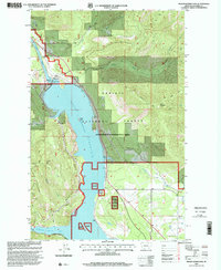 1997 Noxon Rapids Dam2000 Print · USGSHydroelectric development meets the Cabinet Mountains in the late nineties as the Noxon Reservoir dominates the Clark Fork valley. Genealogists and hikers can trace old settlements like Tuscor and Stevens or follow trails across Goat Ridge.
 - 1997 Map of Heron, 2000 Print
 1997 Heron2000 Print · USGSThe Clark Fork valley in the late twentieth century reveals a rugged landscape of timber and mountain water. Genealogists and hikers can trace the Heron settlement, find the local Cemetery, and locate old mining sites like the Brown Hill Mine.
 - 1997 Map of Goat Peak, 2000 Print
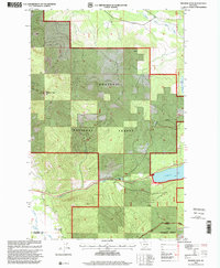
 1997 Goat Peak2000 Print · USGSThe Cabinet Mountains of northwest Montana were preserved as a wilderness area by the late nineties, straddling the county line. Outdoorsmen and historians can trace high-country paths like the Goat Ridge Trail and identify old prospecting sites marked as Mines near Silver Butte Creek.
Showing maps 1-25 of 73
Top cities of Sanders County
- Thompson Falls historical maps
- Plains historical maps
- Hot Springs historical maps
- Trout Creek historical maps
- Noxon historical maps
- Paradise historical maps
Frequently asked questions
- What are the different types of historical maps available for Sanders County?
- What is the oldest map of Sanders County?
- Where can I purchase historical maps of Sanders County for my home or office?
- Where can I download high-res historical maps of Sanders County?
- Are there historical topographic maps available for Sanders County?
- Is there historical aerial imagery available for Sanders County?
- Where are historical maps of Sanders County sourced from?