Old Maps of Lincoln County, Nevada for Hiking & Exploration
Hike through history with 448 historic maps of Lincoln County. Explore old trails, ghost towns, and forgotten backroads — perfect for outdoor adventurers and local explorers.
- Rediscover forgotten places: Map out old mining camps, roads, and footpaths that no longer exist on modern maps.
- Layer with modern tools: Combine with LiDAR or satellite views to plan hikes through historical terrain.
- Made for exploration: Popular among hikers, overlanders, and local history lovers.
Use these maps to find adventure and explore the hidden past of Lincoln County.
Lincoln County, NV maps
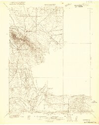
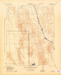
(448)- 1885 Map of Pioche
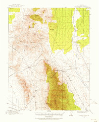
 1885 Pioche1885 Print · USGSLincoln County was a center of frontier mining and ranching during the mid-1880s. Genealogists and historians can trace the early layout of the silver-rich Pioche district and find remote locations like Bullionville, Panacca, and Hackberry Spring.4 unique versions available
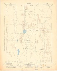
 - 1886 Map of Saint Thomas
 1886 Saint Thomas1886 Print · USGSSoutheastern Nevada's river valleys and early trails are captured here in the late nineteenth century, long before the creation of Lake Mead. Genealogists and historians can locate early settlements like Saint Thomas and Old Callville, and trace river crossings at Stone Ferry and Scanlon Ferry.6 unique versions available
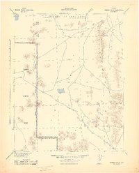
 - 1886 Map of Pioche, 1896 Print
 1886 Pioche1896 Print · USGSEastern Nevada and the Utah borderlands are captured here during the height of the regional mining boom in the late nineteenth century. Genealogists and historians can trace early settlements and vital water sources like Bullionville, Panacca, and Hackberry Spring.
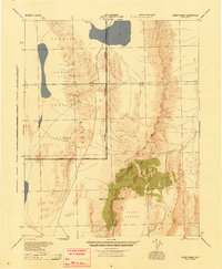
 - 1893 Map of Saint Thomas
 1893 Saint Thomas1893 Print · USGSSouthern Nevada at the close of the nineteenth century reveals a network of river-based settlements and trails. Genealogists and researchers can trace the early locations of Saint Thomas, Old Callville, and the Stone Ferry crossing.
 - 1907 Map of Las Vegas, 1956 Print
 1907 Las Vegas1956 Print · USGSSouthern Nevada is shown at a pivotal moment in the early 1900s as the rail network began to transform the desert landscape. Genealogists and historians can locate early homesteads and landmarks like Las Vegas Ranch, Mormon Well, and the Stirling Mine.
 - 1908 Map of Las Vegas
 1908 Las Vegas1908 Print · USGSSouthern Nevada was a frontier of rail and ranching in the years before major desert expansion. Trace the early footprints of Las Vegas and its surrounding outposts like Arden, Bracken, and the Stirling Mine.4 unique versions available
 - 1915 Map of Bristol Range, 1955 Print
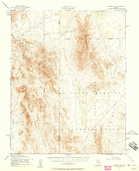
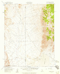
 1915 Bristol Range1955 Print · USGSMining camps and narrow-gauge rails define this Nevada landscape during the height of the early 20th-century silver boom. Genealogists and historians can trace the Pioche Pacific (Narrow Gage) railroad through settlements like Jackrabbit and Bristol.2 unique versions available
 - 1916 Map of Highland, 1957 Print
 1916 Highland1957 Print · USGSMining and high-desert transit define Lincoln County in the years before the Great War. Researchers can trace early infrastructure like the Bristol Mine RR (Narrow Gage) and water-critical landmarks such as Smiths Cabin or Delmues Well.
 - 1917 Map of Bristol Range
 1917 Bristol Range1917 Print · USGSLincoln County mining districts and narrow-gauge rail lines are meticulously preserved in this survey of the Nevada desert during the First World War era. Researchers can trace the industrial infrastructure of Jackrabbit, including its Aerial Tram and the Piocne Pacific Narrow Gage railroad.2 unique versions available
 - 1918 Map of Highland
 1918 Highland1918 Print · USGSLincoln County mining and high-desert transit are captured here during the first World War, as narrow-gauge rails reached into the mountains. Researchers can trace early infrastructure through the Pacific Narrow Gage railroad, the Mendha Mine, and remote landmarks like Smiths Cabin.
 - 1921 Map of NW 1/4 Panaca
 1921 NW 1/4 Panaca1921 Print · USGSLincoln County mining and desert ranching are preserved here during the peak of the silver-lead era. Genealogists and historians can trace the paths of the Pacific (Narrow Gauge) railroad and locate family landmarks like Newman Ranch and Bullionville.2 unique versions available
 - 1942 Map of Emigrant Valley
 1942 Emigrant Valley1942 Print · USGSThe Nevada desert underwent a major wartime transformation in the early 1940s as vast tracts were designated for defense. Researchers can trace the early Military Reservation Boundary and locate isolated landmarks like the mine at Groom and the peak of Bald Mountain.
 - 1942 Map of Indian Spring
 1942 Indian Spring1942 Print · USGSSouthern Nevada's desert landscape is captured here in the early forties as military interests began to redefine the territory. Researchers can trace the early layout of Indian Spring and find remote water sources like Quartz Spring and Mesquite Spring.
 - 1942 Map of Penoyer Valley
 1942 Penoyer Valley1942 Print · USGSLincoln County mining and military operations are documented in the early 1940s, just as the basin became a strategic defense zone. Trace early settlements and mining sites like Tem Piute and Freiburg or locate critical desert water sources at Sand Spring.
 - 1945 Map of Sheep Range
 1945 Sheep Range1945 Print · USGSThe Nevada desert in the mid-1940s is shown here as a massive military training ground just after the war. Researchers can trace the Approximate Reservation Boundary of the Tonopah Aerial Gunnery Range and locate landmarks like Sheep Peak and the Yucca Forest.
 - 1945 Map of Alamo
 1945 Alamo1945 Print · USGSThe Pahranagat Valley during the mid-1940s reveals a sparse but vital desert settlement pattern centered on the town of Alamo. Researchers can trace the early footprint of the Tonopah Aerial Gunnery Range and find remote water sources like Upper Pahranagat Lake and Maynard Lake.
 - 1952 Map of Papoose Lake, 1958 Print
 1952 Papoose Lake1958 Print · USGSThe Nevada desert in the early fifties shows a stark intersection of military testing grounds and high-desert wilderness. Trace early cold-war history across the Nevada Proving Grounds and the Las Vegas Bombing and Gunnery Range, or locate the isolated Kelly Mine.2 unique versions available
 - 1952 Map of White Blotch Springs, 1958 Print
 1952 White Blotch Springs1958 Print · USGSHigh desert military operations define this part of Nevada in the early fifties, where restricted zones meet the basin floor. You can trace the boundaries of the Bombing Range near White Blotch Springs and across the Penoyer Valley.3 unique versions available
 - 1952 Map of Frenchman Lake, 1958 Print
 1952 Frenchman Lake1958 Print · USGSThe high Nevada desert at the dawn of the atomic age is captured here during a pivotal moment of military expansion. Trace the early road network of the Nevada Proving Grounds and locate landmarks like French Peak and Yucca Flat.3 unique versions available
 - 1952 Map of Groom Mine, 1958 Print
 1952 Groom Mine1958 Print · USGSCentral Nevada in the early fifties reveals a high-desert landscape being reshaped by Cold War military expansion. Researchers can trace the proximity of the Groom Mine and Black Metal Mine to the vast Groom Lake and tactical Landing Strip.3 unique versions available
 - 1953 Map of Highland Peak, 1955 Print
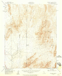
 1953 Highland Peak1955 Print · USGSLincoln County mining and ranching are in full view in the early 1950s as operations span the Bristol and Highland ranges. Researchers can locate specific mine portals and structures like the Manhattan Tunnel, Lucky Boy Shaft, and the remote Wheeler Ranch.2 unique versions available
 - 1953 Map of Bristol Range SE, 1955 Print
 1953 Bristol Range SE1955 Print · USGSMining operations in the Bristol Range were in full swing during the early fifties, defining the economy of this high-desert Nevada landscape. Historians can trace the Old Railroad Grade and locate dozens of specific claims including the Lucky Star Mine, Monarch Mine, and the Bristol School.2 unique versions available
 - 1953 Map of Pioche, 1955 Print
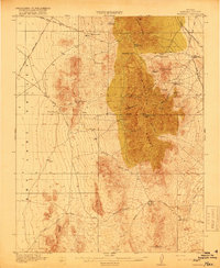
 1953 Pioche1955 Print · USGSThe silver-mining hub of Pioche thrived in the early 1950s as a complex network of company towns and industrial infrastructure. Researchers can trace specific mining operations like the Raymond Ely Extension Mine and the worker residences at Caselton Heights near the Union Pacific Railroad.4 unique versions available
 - 1954 Map of Caliente
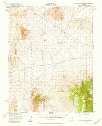
 1954 Caliente1954 Print · USGSLincoln County at mid-century reveals a landscape defined by the Union Pacific rail line and expanding Cold War military ranges. Researchers can trace the heritage of mining towns like Pioche, locate the Prince Mine, or find early airfields at Panaca Airport and Caliente.5 unique versions available
 - 1954 Map of Las Vegas
 1954 Las Vegas1954 Print · USGSLas Vegas and the Mojave Desert are shown in the early fifties as the region's military and recreational footprint expanded. Genealogists and historians can trace the early layout of North Las Vegas, the sites of Indian Springs Air Force Base, and long-established towns like Bunkerville.5 unique versions available
Showing maps 1-25 of 448
Top cities of Lincoln County
- Caliente historical maps
- Pioche historical maps
- Panaca historical maps
- Alamo historical maps
- Bennett Springs historical maps
- Hiko historical maps
See more
Frequently asked questions
- What are the different types of historical maps available for Lincoln County?
- What is the oldest map of Lincoln County?
- Where can I purchase historical maps of Lincoln County for my home or office?
- Where can I download high-res historical maps of Lincoln County?
- Are there historical topographic maps available for Lincoln County?
- Is there historical aerial imagery available for Lincoln County?
- Where are historical maps of Lincoln County sourced from?