1940s Maps of Nye County, Nevada
Explore 17 historic maps of Nye County from the 1940s. These maps offer a rare glimpse into what life looked like during the 1940s — showing old roads, neighborhoods, homes, and landmarks that have changed or disappeared over time.
Whether you're researching your family's past, planning a metal detecting trip, or studying how Nye County's landscape evolved across the 1940s, these high-resolution maps are a powerful tool for exploring the history of this region.
- Focus on a specific era: All maps on this page are from the 1940s, giving you a focused view of this time period.
- See what’s changed: Compare century-old streets, trails, and buildings to today's modern landscape using overlays and satellite layers.
- Research with precision: Use these maps for genealogy, historical research, land use analysis, or educational projects.
- View, download, or print: Maps are fully viewable online in high resolution, and can be downloaded or printed for your own records.
Start exploring Nye County's history through authentic maps from the 1940s. This is your window into the past.
Nye County, NV maps
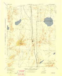
(17)- 1942 Map of Emigrant Valley
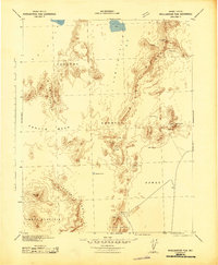
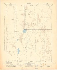 1942 Emigrant Valley1942 Print · USGSThe Nevada desert underwent a major wartime transformation in the early 1940s as vast tracts were designated for defense. Researchers can trace the early Military Reservation Boundary and locate isolated landmarks like the mine at Groom and the peak of Bald Mountain.
 - 1942 Map of Tolicha Peak
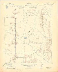
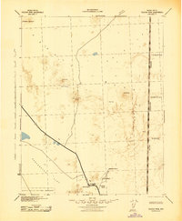 1942 Tolicha Peak1942 Print · USGSNye County ranching and early military expansion meet in the early 1940s. Researchers can locate remote desert outposts like Springdale and Howell Ranch or trace the early boundary of the Tonopah Bombing and Gunnery Range.
 - 1942 Map of Indian Spring
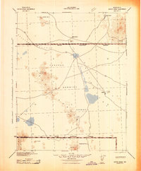
 1942 Indian Spring1942 Print · USGSSouthern Nevada's desert landscape is captured here in the early forties as military interests began to redefine the territory. Researchers can trace the early layout of Indian Spring and find remote water sources like Quartz Spring and Mesquite Spring.
 - 1942 Map of Ivanpah
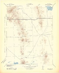
 1942 Ivanpah1942 Print · USGSThe Mojave Desert frontier comes into focus during the early war years, showing a landscape shaped by mining and rail. You can trace the path of the Union Pacific through remote stops like Nipton, Goodsprings, and the junction at Barnwell.
 - 1942 Map of Cactus Range
 1942 Cactus Range1942 Print · USGSNye County was undergoing a major military transformation during the early forties as ranching and mining land was repurposed for defense. Researchers can find old desert outposts like Golden Arrow and Trappmans Camp alongside vital water sources such as Antelope Springs and Cactus Spring.
 - 1942 Map of Reveille Peak
 1942 Reveille Peak1942 Print · USGSNye County's high desert was transitioning into a strategic military corridor during the early 1940s. Researchers can locate remote outposts like Silver Bow and Eden Creek Ranch or trace essential water sources such as Cedar Wells and Jarboe Spring.
 - 1942 Map of Wheelbarrow Peak
 1942 Wheelbarrow Peak1942 Print · USGSNye County's high desert plateaus are captured during the early 1940s as the region began its transition to a military training ground. Genealogists and desert historians can locate critical water sources like Whiterock Spring and Johnnies Water alongside landmarks like Shoshone Mountain.
 - 1942 Map of Penoyer Valley
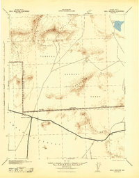
 1942 Penoyer Valley1942 Print · USGSLincoln County mining and military operations are documented in the early 1940s, just as the basin became a strategic defense zone. Trace early settlements and mining sites like Tem Piute and Freiburg or locate critical desert water sources at Sand Spring.
 - 1942 Map of Skull Mountain
 1942 Skull Mountain1942 Print · USGSNye County's high desert was undergoing a massive transformation during the early 1940s as military testing ranges expanded across the terrain. Researchers can trace historic desert routes and landmarks like Cane Spring, the Horn Silver Mine, and the remote Fairbanks settlement.
 - 1942 Map of Bullfrog
 1942 Bullfrog1942 Print · USGSThe high desert of southern Nevada and eastern California is shown here during the early war years, documenting the region's mining and railroad legacy. Researchers can trace the T & T (Abandoned) railroad grade and locate mining sites like Jumbo and Ladd near Rhyolite.
 - 1945 Map of Goldfield
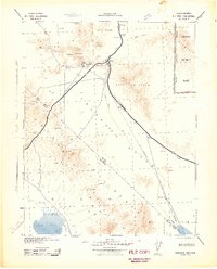
 1945 Goldfield1945 Print · USGSEsmeralda County's high desert landscape is shown here at the end of the Second World War, capturing the region's mining roots and new military role. Genealogists and historians can trace the Tonopah and Goldfield rail line through Klondike and locate remote water sources like Stonewall Spr.
 - 1947 Map of Kingman, 1948 Print
 1947 Kingman1948 Print · USGSThe tri-state Mojave desert region comes into focus during the late 1940s, as post-war travel began to surge along U S 66. Genealogists and historians can trace the mining-and-rail economy through the Atchison Topeka and Santa Fe line, the Copper World Mine, and old settlements like Oatman or Goodsprings.2 unique versions available
 - 1948 Map of Kingman
 1948 Kingman1948 Print · USGSThe Mojave Desert at the dawn of the fifties shows a landscape of deep canyons and booming mines along the Arizona and Nevada border. Genealogists and historians can trace rail-stop towns and mining claims like Oatman, Searchlight, and the Mohawk Mine.
 - 1948 Map of Paradise Peak
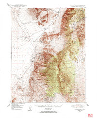 1948 Paradise Peak1948 Print · USGSMining and desert settlement come into focus in 1940s Nye County, where industrial camps and high peaks define the landscape. Trace the history of the mineral boom through the Sierra Magnesite Camp, the Downeyville site, and the remote Victory Tungsten Mine.2 unique versions available
 - 1948 Map of Walker Lake
 1948 Walker Lake1948 Print · USGSThe high desert of Nevada and the eastern Sierra Nevada are captured just after the war as mining and ranching shaped the local economy. Genealogists can trace family connections to centers like Hawthorne and Mina or locate the historic Rockland Mines and Aurora.2 unique versions available
 - 1948 Map of Death Valley
 1948 Death Valley1948 Print · USGSIn the late 1940s, this desert frontier was defined by isolated mining camps and military restricted zones. Researchers can trace the routes between Furnace Creek Ranch and Rhyolite, or locate remote sites like the Modoc Mine and Ballarat.2 unique versions available
 - 1948 Map of Ione, 1956 Print
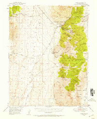 1948 Ione1956 Print · USGSIn the heart of Nye County during the late 1940s, this area shows the enduring legacy of the Nevada mining frontier. Researchers can trace the footprints of old camps and extraction sites like Berlin, Grantsville, and the Nevada Cinnabar Mine among the peaks of the Toiyabe National Forest.2 unique versions available
End of results
Showing maps 1-17 of 17
Top cities of Nye County
- Pahrump historical maps
- Tonopah historical maps
- Amargosa Valley historical maps
- Beatty historical maps
- Scotty's Junction historical maps
- Reveille historical maps
Frequently asked questions
- What are the different types of historical maps available for Nye County?
- What is the oldest map of Nye County?
- Where can I purchase historical maps of Nye County for my home or office?
- Where can I download high-res historical maps of Nye County?
- Are there historical topographic maps available for Nye County?
- Is there historical aerial imagery available for Nye County?
- Where are historical maps of Nye County sourced from?