1990s Maps of Catron County, New Mexico
Explore 98 historic maps of Catron County from the 1990s. These maps offer a rare glimpse into what life looked like during the 1990s — showing old roads, neighborhoods, homes, and landmarks that have changed or disappeared over time.
Whether you're researching your family's past, planning a metal detecting trip, or studying how Catron County's landscape evolved across the 1990s, these high-resolution maps are a powerful tool for exploring the history of this region.
- Focus on a specific era: All maps on this page are from the 1990s, giving you a focused view of this time period.
- See what’s changed: Compare century-old streets, trails, and buildings to today's modern landscape using overlays and satellite layers.
- Research with precision: Use these maps for genealogy, historical research, land use analysis, or educational projects.
- View, download, or print: Maps are fully viewable online in high resolution, and can be downloaded or printed for your own records.
Start exploring Catron County's history through authentic maps from the 1990s. This is your window into the past.
Catron County, NM maps
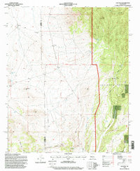
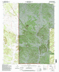
(98)- 1991 Map of Escudilla Mountain
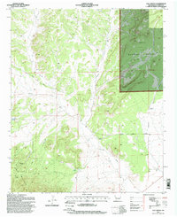
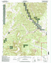
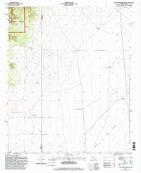
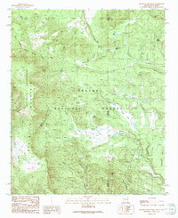 1991 Escudilla Mountain1991 Print · USGSHigh-altitude wilderness and forest lands define the Arizona-New Mexico border in the 1990s. Researchers can trace remote alpine hydrology and landmarks from Profanity Ridge to the waters of Romero Lake and McFate Spring.
 - 1991 Map of Blue
 1991 Blue1991 Print · USGSThe Arizona-New Mexico state line comes alive in the 1990s as it cuts through the high canyons of the Apache National Forest. Genealogists and researchers can trace local family markers at Jones Cemetery or navigate the remote terrain near WS Mountain and Devils Monument.
 - 1991 Map of Luna Lake
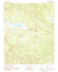 1991 Luna Lake1991 Print · USGSThe high-country borderlands of the Arizona and New Mexico line are documented here in the early 1990s. Local historians can trace the headwaters of the San Francisco River near Luna Lake and locate the small Cem and Double J Ranch.
 - 1991 Map of Maness Peak
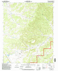
 1991 Maness Peak1991 Print · USGSThe high Arizona-New Mexico border country comes to life in this early 1990s record of the Blue River valley. Local historians can trace family ranching footprints at Luce Ranch or Lazy YJ Ranch and locate community landmarks like the Blue School and Blue Cemetery.
 - 1995 Map of Cal Ship Mesa, 1998 Print
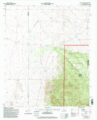
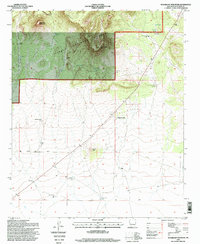
 1995 Cal Ship Mesa1998 Print · USGSThe high mesas of western New Mexico are captured in the mid-1990s as the Forest Service managed the rugged terrain of the Datil Mountains. Researchers can locate isolated water improvements and land markers like Government Tank, Sawmill Well, and Blue Place Well.2 unique versions available
 - 1995 Map of Dusty, 1998 Print
 1995 Dusty1998 Print · USGSSocorro and Catron counties appear here in the mid-1990s, revealing a landscape of high-country ranching and forest land. Genealogists and historians can locate family landmarks such as McCracken Ranch, Henderson Ranch, and the Pigeon Windmill.
 - 1995 Map of Log Canyon, 1998 Print
 1995 Log Canyon1998 Print · USGSThe high-country ranching life of Catron County is captured here in the mid-1990s, showcasing a landscape of isolated outposts and seasonal draws. Researchers can trace family-named sites like Thurmond Ranch and Bull Ranch or locate the remote Cem near Greens Draw.
 - 1995 Map of Third Canyon, 1998 Print
 1995 Third Canyon1998 Print · USGSNew Mexico ranching and national forest lands are documented here in the mid-1990s, capturing a remote landscape of high mesas and canyons. Researchers can trace the layout of McPhaul Ranch or locate essential water sources like Swingle Windmill and Trinchera Lake.
 - 1995 Map of Kellog Well, 1998 Print
 1995 Kellog Well1998 Print · USGSThe high desert of Socorro County comes into focus in the mid-1990s as the western plains meet the mountain canyons. Researchers can trace land use at the forest edge, locating ranching landmarks like Satahite Place and essential water sources such as Kellog Well.
 - 1995 Map of Datil, 1998 Print
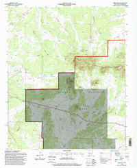
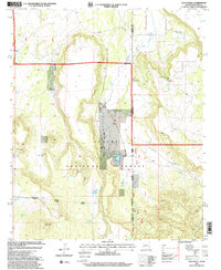
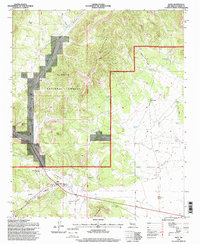 1995 Datil1998 Print · USGSThe ranching and forest lands of Catron County come into focus in the mid-nineties as the community of Datil grew around its canyon crossroads. Genealogists and local historians can trace family-named sites such as Jeffers Place and Eary Ranch or locate the Datil Cem.
 - 1995 Map of Crosby Springs, 1998 Print
 1995 Crosby Springs1998 Print · USGSCatron County ranching country is documented here in the mid-1990s, showing a landscape defined by isolated water tanks and windmills. You can trace the historic grazing infrastructure at the Flying V No 1 Windmill Grave, Baldwin Cabin, and Crosby Springs.
 - 1995 Map of Sugarloaf Mountain, 1998 Print
 1995 Sugarloaf Mountain1998 Print · USGSHigh desert ranching and forest land in Catron County are captured here during the 1990s. Researchers can trace the water-rights history of the Cibola National Forest through features like Gutierrezville, Henderson Two Sections Well, and Sugarloaf Well.
 - 1995 Map of Red Flats, 1998 Print
 1995 Red Flats1998 Print · USGSThe high desert of Catron County is captured here in the mid-1990s as the Continental Divide crosses the Sawtooth Mountains. Researchers can trace old livestock water sources and local landmarks like the Rodeo Ground and Capital Dome.
 - 1995 Map of D Cross Mountain, 1998 Print
 1995 D Cross Mountain1998 Print · USGSThe high canyons and mountain ranges of Socorro County are documented here in the mid-1990s as the Forest Service updated its territorial records. Researchers can trace remote sites like Martin Ranch, several unnamed Prospects, and water sources like Dog Springs.
 - 1995 Map of Oak Peak, 1998 Print
 1995 Oak Peak1998 Print · USGSThe high-desert ranching and prospecting lands of Socorro and Catron Counties are captured here in the mid-1990s. Researchers can trace land use through water features like Kellog Well and Frenchmans Well, or locate the specific topography of Lost Mines Hill.
 - 1995 Map of Cox Peak, 1998 Print
 1995 Cox Peak1998 Print · USGSCatron County, New Mexico, is shown here as it appeared in the mid-1990s within the high country of the Cibola National Forest. Researchers can locate historic water sources like Refrigerator Place Well, Jones Spring, and Lemon Lake Well.
 - 1995 Map of Pasture Canyon, 1998 Print
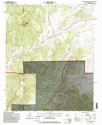
 1995 Pasture Canyon1998 Print · USGSCatron County ranching and forest lands are documented here during the mid-nineties, showing a landscape defined by canyons and isolated outposts. Researchers can locate remote sites like White House Ranch, McCord Place, and Grapevine Cabin alongside numerous named springs and wells.
 - 1995 Map of Madre Mountain, 1998 Print
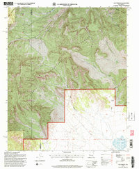
 1995 Madre Mountain1998 Print · USGSThe high canyons of Catron County come alive in this mid-nineties survey of the Cibola National Forest. Researchers can trace remote ranching outposts and high-country landmarks like Double Circle Ranch, Webster Cabin, and the Davenport Lookout.
 - 1995 Map of Lion Mountain NW, 1998 Print
 1995 Lion Mountain NW1998 Print · USGSHigh desert ranching and forest management define this 1990s landscape at the edge of the Plains of San Agustin. Researchers can trace old livestock water systems like Antelope Windmill and family-named sites such as Fullerton Well.
 - 1995 Map of Dog Springs, 1998 Print
 1995 Dog Springs1998 Print · USGSSocorro and Catron Counties remain a high-desert frontier in the mid-1990s, defined by the remote canyons of the Cibola National Forest. Genealogists and historians can trace essential water sources and livestock markers like the John Henry Windmill, Ramsey Windmill, and Blue Mesa Well.
 - 1997 Map of Maple Peak, 2000 Print
 1997 Maple Peak2000 Print · USGSThe Arizona and New Mexico borderlands come alive in the late nineties, where high-desert ranching life is etched into the canyons and mesas. Researchers can locate the Coalson Ranch, a lonely Grave, and numerous historic water features like Kelly Well Spring and Smoothing Iron Tank.
 - 1997 Map of Blue, 2000 Print
 1997 Blue2000 Print · USGSThe high wilderness of the Blue Range in the late nineties is captured here, straddling the Arizona and New Mexico border. Genealogists and historians can locate the Jones Cemetery and early homesteading sites like Marks Ranch or the cabins at Campbell Flat.
 - 1997 Map of Alma Mesa, 2000 Print
 1997 Alma Mesa2000 Print · USGSThe Arizona and New Mexico borderlands come alive in this late-nineties survey of high mesas and primitive wilderness. Trace the cattle-country history of the region through landmarks like Charlie Moore Place, Cradle-Mesa Corral, and the Stateline Camp Well.
 - 1997 Map of Loco Knoll, 2000 Print
 1997 Loco Knoll2000 Print · USGSThe Arizona and New Mexico borderlands come alive in the late nineties, showing a landscape of remote cattle operations and forest service districts. Researchers can trace the infrastructure of the H-V Ranch, from its Landing Strip to the waters of Pratt Lake.
 - 1997 Map of Maness Peak, 2000 Print
 1997 Maness Peak2000 Print · USGSThe Blue River valley at the turn of the millennium shows a landscape where ranching life persists along the Arizona-New Mexico line. Genealogists and researchers can locate the Blue Cemetery, Blue School, and early homesteads like Luce Ranch.
Showing maps 1-25 of 98
Top cities of Catron County
Frequently asked questions
- What are the different types of historical maps available for Catron County?
- What is the oldest map of Catron County?
- Where can I purchase historical maps of Catron County for my home or office?
- Where can I download high-res historical maps of Catron County?
- Are there historical topographic maps available for Catron County?
- Is there historical aerial imagery available for Catron County?
- Where are historical maps of Catron County sourced from?