1910s Maps of Catron County, New Mexico
Explore 10 historic maps of Catron County from the 1910s. These maps offer a rare glimpse into what life looked like during the 1910s — showing old roads, neighborhoods, homes, and landmarks that have changed or disappeared over time.
Whether you're researching your family's past, planning a metal detecting trip, or studying how Catron County's landscape evolved across the 1910s, these high-resolution maps are a powerful tool for exploring the history of this region.
- Focus on a specific era: All maps on this page are from the 1910s, giving you a focused view of this time period.
- See what’s changed: Compare century-old streets, trails, and buildings to today's modern landscape using overlays and satellite layers.
- Research with precision: Use these maps for genealogy, historical research, land use analysis, or educational projects.
- View, download, or print: Maps are fully viewable online in high resolution, and can be downloaded or printed for your own records.
Start exploring Catron County's history through authentic maps from the 1910s. This is your window into the past.
Catron County, NM maps
(10)- 1910 Map of Mogollon, 1959 Print
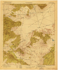
 1910 Mogollon1959 Print · USGSThe high mining camps and river settlements of Catron County come alive in this survey from the early 1900s. Genealogists and historians can trace old homesteads and industrial sites like the Meader Stage Sta, Box N Ranch, and the Power Plant near Graham.2 unique versions available
 - 1911 Map of Alum Mountain, 1959 Print
 1911 Alum Mountain1959 Print · USGSThe upper Gila River wilderness is documented here just after the turn of the century, showing a landscape of remote cattle ranches and early mining claims. Genealogists and researchers can trace family-named sites like TJ Ranch and the Meerschaum Mine, or locate the Gila Cliff-Dwellings National Monument.
 - 1912 Map of Mogollon
 1912 Mogollon1912 Print · USGSNew Mexico's high timber and mining country come to life in this survey from the years just before statehood. Researchers can trace the early industrial footprint of Cooney and Mogollon or locate remote outposts like Meadows Stage Sta and N Bar Ranch.2 unique versions available
 - 1913 Map of Alum Mountain
 1913 Alum Mountain1913 Print · USGSNew Mexico's high wilderness is captured here just after statehood, documenting the remote ranching outposts and ancient sites along the Gila River. Researchers can locate early twentieth-century landmarks like Gila Cliff Dwellings National Monument, the Meerschaum Mine, and the XSX Ranch.3 unique versions available
 - 1913 Map of Morenci, 1954 Print
 1913 Morenci1954 Print · USGSArizona's copper country and high timberlands meet in this pre-war survey of the Morenci district and Apache National Forest. Researchers can trace the early industrial footprint of Morenci and Clifton or find family landmarks like Miller Cabin and Cooks Ranch.2 unique versions available
 - 1915 Map of Morenci
 1915 Morenci1915 Print · USGSGreenlee County during the early 1900s shows a landscape defined by industrial copper mining and isolated high-desert ranching. Genealogists and historians can trace family locations from the Eagle Creek School to historic homesteads like Dudley Ranch and the settlement of Oroville.3 unique versions available
 - 1915 Map of Reserve, 1960 Print
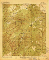
 1915 Reserve1960 Print · USGSSocorro County and the Gila National Forest wilderness are documented here in the early twentieth century during the height of the ranger station era. Genealogists and researchers can trace the early plazas at San Francisco Plaza or locate Steven's Sawmill and the Tularosa School.
 - 1917 Map of Broom Mountain
 1917 Broom Mountain1917 Print · USGSValencia County at the close of the First World War shows a landscape of high mesas and scattered homesteads. Genealogists and historians can trace early ranching outposts like Bodenheimer and Th Garcia or locate the former Miller Post Office.
 - 1918 Map of Pelona
 1918 Pelona1918 Print · USGSSocorro County ranching life during the First World War centered on the high plains and forested ranges of west-central New Mexico. Trace the legacy of early families at the O Bar O Ranch or follow the old route through Horse Spr Stage Station.2 unique versions available
 - 1918 Map of Reserve
 1918 Reserve1918 Print · USGSUpper Gila country in the years following the Great War reveals a landscape of isolated mountain plazas and early forest service outposts. Researchers can trace the lineage of remote homesteads at Kiehne Ranch, Stevens Sawmill, and the Tularosa School.2 unique versions available
End of results
Showing maps 1-10 of 10
Top cities of Catron County
Frequently asked questions
- What are the different types of historical maps available for Catron County?
- What is the oldest map of Catron County?
- Where can I purchase historical maps of Catron County for my home or office?
- Where can I download high-res historical maps of Catron County?
- Are there historical topographic maps available for Catron County?
- Is there historical aerial imagery available for Catron County?
- Where are historical maps of Catron County sourced from?