Old Maps of Cibola County, New Mexico for Hiking & Exploration
Hike through history with 648 historic maps of Cibola County. Explore old trails, ghost towns, and forgotten backroads — perfect for outdoor adventurers and local explorers.
- Rediscover forgotten places: Map out old mining camps, roads, and footpaths that no longer exist on modern maps.
- Layer with modern tools: Combine with LiDAR or satellite views to plan hikes through historical terrain.
- Made for exploration: Popular among hikers, overlanders, and local history lovers.
Use these maps to find adventure and explore the hidden past of Cibola County.
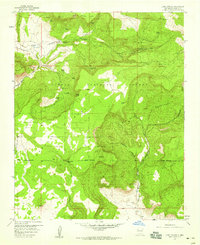
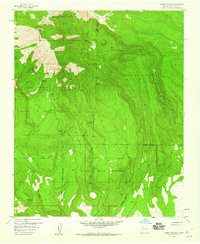
Cibola County, NM maps
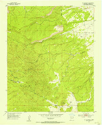
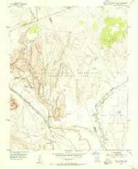
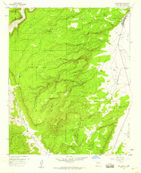
(648)- 1883 Map of Mt. Taylor
 1883 Mt. Taylor1883 Print · USGSThe high-desert frontier of New Mexico comes to life in the 1880s, centered on the towering Mt Taylor. Researchers can trace the early path of the Atlantic and Pacific Railroad and locate settlements like Old Fort Wingate and Laguna.
 - 1886 Map of St Johns
 1886 St Johns1886 Print · USGSApache County in the 1880s was a landscape of emerging pioneer outposts and high-plateau cattle ranching. Researchers can trace the early footprints of settlements like St Johns and Erastus or locate the original path of the Atlantic and Pacific Railroad.
 - 1886 Map of Wingate
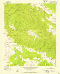
 1886 Wingate1886 Print · USGSThe high deserts of western New Mexico are shown during the expansion of the rail era in the mid-1880s. Genealogists and historians can trace early settlements and vital water sources like Gallup, Old Zuñi, and the historic Fort Wingate along the Atlantic and Pacific Railroad.
 - 1886 Map of Mt. Taylor
 1886 Mt. Taylor1886 Print · USGSNorthwestern New Mexico in the mid-1880s reveals a high-desert territory where early rail commerce meets long-standing mountain settlements. Researchers can trace the path of the Atlantic and Pacific Railroad past Old Fort Wingate and the historic villages of Laguna and Cebolletta.
 - 1892 Map of St Johns
 1892 St Johns1892 Print · USGSArizona's eastern frontier is documented here in the late nineteenth century as cattle ranching and early settlements followed the path of the river. Genealogists and historians can trace the foundations of St Johns and Springerville or locate long-standing sites like Erastus and Windmill Ranch.5 unique versions available
 - 1892 Map of Wingate
 1892 Wingate1892 Print · USGSNorthwestern New Mexico territory comes to life during the expansion of the rail era, centered on the strategic military and trade routes of the high desert. Researchers can trace the path of the Atlantic and Pacific Railroad past Fort Wingate and through early settlements like Gallup and Old Zuni.4 unique versions available
 - 1892 Map of Mt. Taylor, 1896 Print
 1892 Mt. Taylor1896 Print · USGSNorthwestern New Mexico in the late nineteenth century was a territory of rail expansion and ancient volcanic landmarks. Researchers can trace the path of the Atlantic and Pacific Railroad past Old Fort Wingate and the pueblo at Laguna.
 - 1899 Map of Mt. Taylor
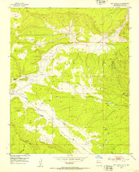
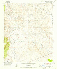
 1899 Mt. Taylor1899 Print · USGSNorthwestern New Mexico in the late nineteenth century is a landscape of vast mesas and early rail stops before modern highways arrived. Genealogists and historians can trace the foundations of Grant, San Mateo, and Old Fort Wingate along the Santa Fe Pacific Railroad.5 unique versions available
 - 1917 Map of Cerro Verde
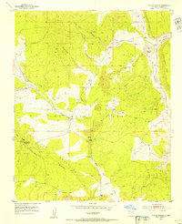
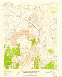
 1917 Cerro Verde1917 Print · USGSNorthwestern New Mexico’s high desert landscape is captured here during the First World War era, showing a mix of ancient land grants and rail-side outposts. Genealogists and historians can trace family-named sites like Vigil, Baca, and the Correo Post Office along the Atchison Topeka and Santa Fe line.
 - 1917 Map of Broom Mountain
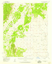
 1917 Broom Mountain1917 Print · USGSValencia County at the close of the First World War shows a landscape of high mesas and scattered homesteads. Genealogists and historians can trace early ranching outposts like Bodenheimer and Th Garcia or locate the former Miller Post Office.
 - 1951 Map of Mt Sedgwick, 1953 Print
 1951 Mt Sedgwick1953 Print · USGSValencia County, New Mexico, is depicted here in the early 1950s, centered on the high peaks and deep drainages of the Cibola National Forest. Topographers and local historians can trace the canyon networks of Prop Canyon and find isolated cattle-range features like Ojo Redondo.2 unique versions available
 - 1952 Map of Valle Largo, 1953 Print
 1952 Valle Largo1953 Print · USGSThe high timberlands and volcanic ridges of Cibola County are captured here in the early fifties, following the 1945 aerial surveys. Researchers can trace the path of the Continental Divide past the Aragon Ranch and remote watering points like Aragon Spring.3 unique versions available
 - 1952 Map of Post Office Flat, 1953 Print
 1952 Post Office Flat1953 Print · USGSIn the Zuni Mountains during the early fifties, this area shows the rugged transition of the Continental Divide. Genealogists and historians can trace family locations at the Serna Homestead or follow industrial sites like the Sawmill (Aban'd) and Mirabal Mine.3 unique versions available
 - 1952 Map of Paxton Springs, 1954 Print
 1952 Paxton Springs1954 Print · USGSThe Zuni Mountains high country comes into focus in the early fifties, capturing the remote landscapes of the Cibola National Forest. Trace the path of the Continental Divide past Paxton Springs and the Oso Ridge Lookout Tower.8 unique versions available
 - 1954 Map of South Garcia, 1955 Print
 1954 South Garcia1955 Print · USGSThe high desert of Valencia County in the mid-1950s is defined here by tribal lands and cattle ranching. Trace early landmarks like the Antonio Sedillo Grant Headquarters and the Atchison Topeka and Santa Fe railroad.2 unique versions available
 - 1954 Map of Canoncito School, 1955 Print
 1954 Canoncito School1955 Print · USGSBernalillo and Valencia counties meet in the high desert during the mid-1950s, a landscape defined by Indigenous lands and mineral exploration. Researchers can trace historic locations such as the Canoncito Navajo Day School, Pueblo Ruins, and the Fern Mine.3 unique versions available
 - 1954 Map of Saint Johns, 1968 Print
 1954 Saint Johns1968 Print · USGSThe high plateau of the Arizona-New Mexico border is captured here in the mid-1950s, showing the intersection of tribal lands and national forests. Researchers can trace the cattle country and mountain outposts from Saint Johns to Pie Town and McNary.3 unique versions available
 - 1954 Map of Socorro, 1972 Print
 1954 Socorro1972 Print · USGSMid-century New Mexico comes into focus as the Rio Grande valley and the surrounding high desert undergo post-war growth. Genealogists and historians can trace old mountain settlements like Tajique and Punta de Agua or locate remote sites like the Torrance Mine.2 unique versions available
 - 1954 Map of Gallup, 1973 Print
 1954 Gallup1973 Print · USGSNative American tribal lands and the railroad corridor of the Southwest appear here at the midpoint of the century. Trace historic sites and remote settlements from Window Rock to the Fort Wingate Army Depot and Bibo.2 unique versions available
 - 1956 Map of South Garcia, 1958 Print
 1956 South Garcia1958 Print · USGSThe high desert landscape west of Albuquerque is captured here in the mid-fifties as ranching and rail infrastructure defined the region. Researchers can trace historic ranch boundaries and water sources like the Antonio Sedillo Grant Hdqrs, T X Ranch, and Marys Windmill.3 unique versions available
 - 1956 Map of Mesa Aparejo, 1958 Print
 1956 Mesa Aparejo1958 Print · USGSRanching life in the New Mexico desert is captured here in the mid-fifties, spanning the Valencia and Socorro county line. Genealogists and historians can trace family-named sites like Romero Ranch, Yriart Ranch, and the outpost at Kings Rest.2 unique versions available
 - 1957 Map of Saint Johns
 1957 Saint Johns1957 Print · USGSThe Arizona-New Mexico borderlands are captured here in the mid-fifties, showing the high-country settlements and federal lands before modern development. Genealogists and historians can trace old homesteads and landmarks like the Red Hill Post Office, Lyman Reservoir, and the mountain communities of Eagar and Springerville.
 - 1957 Map of San Rafael, 1959 Print
 1957 San Rafael1959 Print · USGSIn the high desert of Valencia County during the late fifties, the village of San Rafael serves as a gateway to the volcanic uplands. Genealogists and hikers can trace the Agua Fria Trail and locate family sites like the Porter Cemetery or the historic Ojo del Gallo.2 unique versions available
 - 1957 Map of Lobo Springs, 1959 Print
 1957 Lobo Springs1959 Print · USGSCibola National Forest and the Acoma Pueblo Indian Land met in this high-desert landscape during the late fifties. Researchers can trace remote life through landmarks like Tietjen Ranch, find a lone Grave, and locate numerous named water sources like De Armand Spring.3 unique versions available
 - 1957 Map of Mount Taylor, 1959 Print
 1957 Mount Taylor1959 Print · USGSThe high peaks of the San Mateo Mountains define this late 1950s New Mexico survey. Local historians and researchers can trace the complex boundaries between the Laguna Indian Reservation and Cibola National Forest or locate early water sources like Gooseberry Spring.3 unique versions available
Showing maps 1-25 of 648
Top cities of Cibola County
Frequently asked questions
- What are the different types of historical maps available for Cibola County?
- What is the oldest map of Cibola County?
- Where can I purchase historical maps of Cibola County for my home or office?
- Where can I download high-res historical maps of Cibola County?
- Are there historical topographic maps available for Cibola County?
- Is there historical aerial imagery available for Cibola County?
- Where are historical maps of Cibola County sourced from?