1990s Maps of Cibola County, New Mexico
Explore 23 historic maps of Cibola County from the 1990s. These maps offer a rare glimpse into what life looked like during the 1990s — showing old roads, neighborhoods, homes, and landmarks that have changed or disappeared over time.
Whether you're researching your family's past, planning a metal detecting trip, or studying how Cibola County's landscape evolved across the 1990s, these high-resolution maps are a powerful tool for exploring the history of this region.
- Focus on a specific era: All maps on this page are from the 1990s, giving you a focused view of this time period.
- See what’s changed: Compare century-old streets, trails, and buildings to today's modern landscape using overlays and satellite layers.
- Research with precision: Use these maps for genealogy, historical research, land use analysis, or educational projects.
- View, download, or print: Maps are fully viewable online in high resolution, and can be downloaded or printed for your own records.
Start exploring Cibola County's history through authentic maps from the 1990s. This is your window into the past.
Cibola County, NM maps
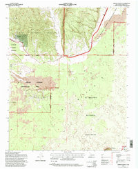
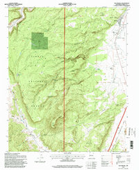
(23)- 1995 Map of San Mateo, 1997 Print
 1995 San Mateo1997 Print · USGSThe high plateau of New Mexico's western ranchlands comes into focus in the mid-1990s as it transitions toward the forest boundary. Researchers can trace land grants and water sources from San Mateo to the San Mateo Mine and Marcus Ranch.
 - 1995 Map of Post Office Flat, 1997 Print
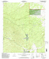
 1995 Post Office Flat1997 Print · USGSCibola County at the end of the twentieth century reveals a landscape of isolated ranching outposts and high-desert canyons. Genealogists and researchers can pinpoint old family-named sites like the Serna Homestead, the Wilcoxson Ranch, and the namesake Post Office Flat.
 - 1995 Map of Cerro Pelon, 1997 Print
 1995 Cerro Pelon1997 Print · USGSThe high mesa country of Cibola County is captured here in the mid-nineties, showing the intersection of Spanish land grants and national forest lands. Researchers can locate historic water sources and camps like Fernandez Camp Spring, La Mosca Lookout, and San Lucas Spring.
 - 1995 Map of Ramah, 1997 Print
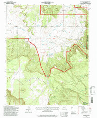
 1995 Ramah1997 Print · USGSIn the mid-nineties, this part of the Continental Divide shows the intersection of high-desert ranching and the forested slopes of the Zuni Mountains. Researchers can locate legacy family sites like Old Bond Ranch and Clawson Homestead or trace the Mormon Colony Cemetery near the Ramah Reservoir.
 - 1995 Map of Kettner Canyon, 1997 Print
 1995 Kettner Canyon1997 Print · USGSIn the mid-1990s, the high country of the Zuni Mountains remained a landscape of remote canyons and high-altitude parks. Trace the path of the Continental Divide past Black Lake, Little Notch, and the meadows of Rice Park.
 - 1995 Map of Page, 1997 Print
 1995 Page1997 Print · USGSThe high country of McKinley County in the mid-1990s reveals a landscape of isolated ranching outposts and rugged mountain ridges. Genealogists and researchers can trace family-named sites like Radosevich Ranch, Polich Place, and the small settlement at Page.
 - 1995 Map of Dos Lomas, 1997 Print
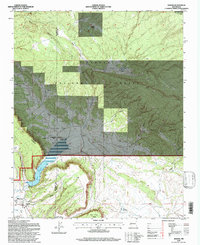
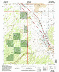
 1995 Dos Lomas1997 Print · USGSNorthwestern New Mexico’s high desert plateau was a hub of intense mineral extraction in the 1990s. Genealogists and industrial historians can trace early ranching at Rancho del Puerto alongside massive operations like the Anaconda Section Nine Strip Mine and Zia Mines.
 - 1995 Map of Ice Caves, 1998 Print
 1995 Ice Caves1998 Print · USGSCibola County’s volcanic landscape is captured here in the mid-1990s, where the Continental Divide crosses ancient lava flows. Genealogists and historians can locate remote landmarks like Bandera Crater, the Ice Caves, and various old Mines.
 - 1995 Map of Prewitt, 1998 Print
 1995 Prewitt1998 Print · USGSThe high mesa country of McKinley County in the mid-1990s reveals a land shaped by the Atchison Topeka and Santa Fe railroad and desert ranching. Genealogists and local historians can trace the foundations of Prewitt, find the Prewitt PO, and explore the shoreline of Bluewater Lake at the foot of Salitre Mesa.
 - 1995 Map of Laguna Canoneros, 1998 Print
 1995 Laguna Canoneros1998 Print · USGSHigh-altitude mesa country in the mid-1990s reveals a landscape of traditional land grants and seasonal camps near the McKinley and Cibola county line. Researchers can trace land use patterns through Cebolleta Mesa Grant and isolated sites like Cuates Camp and Casa Fria.
 - 1995 Map of El Morro, 1998 Print
 1995 El Morro1998 Print · USGSThe high mesa and canyon country of western New Mexico is captured here in the late twentieth century. Genealogists and historians can locate family landmarks like El Morro and Tinaja Cemetery, along with the legendary Inscription Rock.
 - 1995 Map of Arrosa Ranch, 1998 Print
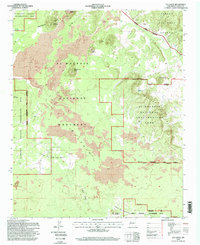
 1995 Arrosa Ranch1998 Print · USGSWest-central New Mexico in the mid-1990s shows a landscape of volcanic fields and remote cattle operations. Researchers can locate historic homesteads like Porter Ranch and Arrosa Ranch or trace the path of the Zuni Acoma Trail.
 - 1995 Map of Milan, 1998 Print
 1995 Milan1998 Print · USGSThe lava-scarred terrain around Milan and Toltec is captured here in the mid-1990s, showcasing a landscape where ranching meets volcanic geology. Genealogists and historians can trace family properties like Schneemann Ranch, locate the Bluewater Cemetery, and see the early layout of the Grants Municipal Airport.
 - 1995 Map of Mount Taylor, 1998 Print
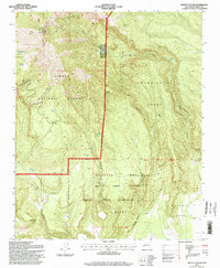 1995 Mount Taylor1998 Print · USGSMount Taylor and the San Mateo Mountains define this high-altitude landscape in the mid-1990s. Researchers can trace complex land divisions between the Laguna Indian Reservation, the Cebolleta Grant, and springs like Raton Spring.
 - 1995 Map of Valle Largo, 1998 Print
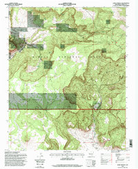
 1995 Valle Largo1998 Print · USGSCibola County high country in the mid-nineties shows the remote intersection of the Continental Divide and the Zuni Mountains. Local historians can trace the paths of Tinaja Road to family-named sites like Aragon Ranch and the Valle Largo Cabin.
 - 1995 Map of San Rafael, 1998 Print
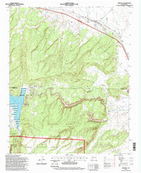
 1995 San Rafael1998 Print · USGSIn the mid-1990s, the village of San Rafael served as a gateway to the canyons and mesas of the Cibola National Forest. Researchers can trace old timber infrastructure like the Old Logging Chute or locate family sites at Porter Cemetery and Ojo de Gallo.
 - 1995 Map of Mount Sedgwick, 1998 Print
 1995 Mount Sedgwick1998 Print · USGSCibola National Forest comes into sharp focus during the 1990s, revealing a landscape of high mesas and critical water points. Researchers can trace the drainages of Limekiln Canyon and Pole Canyon or locate the peak of Mount Sedgwick.
 - 1995 Map of Cerro Hueco, 1998 Print
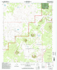 1995 Cerro Hueco1998 Print · USGSCibola County in the mid-1990s reveals a high-desert landscape defined by the volcanic features of El Malpais and the Continental Divide. Trace the location of historic outposts like Mason Ranch and prominent peaks such as Cerro Americano.
 - 1995 Map of Cottonwood Canyon, 1998 Print
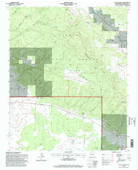
 1995 Cottonwood Canyon1998 Print · USGSHigh desert ranching and forest management define this corner of New Mexico in the mid-1990s. Researchers can trace remote family holdings like Coddington Ranch and Irvin Ranch, or locate water resources such as Rock Dam and Twin Springs.
 - 1995 Map of Lobo Springs, 1998 Print
 1995 Lobo Springs1998 Print · USGSCibola County ranching and tribal lands are surveyed here during the late twentieth century. Genealogists and historians can locate the Tietjen Ranch, the Coal Mine (Abandoned), and numerous water sources like Lobo Springs.
 - 1995 Map of Paxton Springs, 1998 Print
 1995 Paxton Springs1998 Print · USGSThe high Zuni Mountains and Continental Divide are captured here in the mid-1990s, revealing a landscape shaped by volcanic geology and forest management. Trace the Old Railroad Grade, locate the settlement at Paxton Springs, or find family sites like Arrosa Ranch.
 - 1995 Map of Pine Canyon, 1998 Print
 1995 Pine Canyon1998 Print · USGSHigh desert forest and seasonal waterways define this New Mexico landscape in the mid-1990s. Researchers can trace land use at the Ford Ranch, locate the Cottonwood Gulch Camp, and study the shoreline of Bluewater Lake.
 - 1995 Map of Grants, 1998 Print
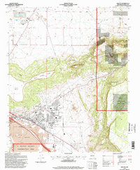 1995 Grants1998 Print · USGSGrants and the surrounding high desert are captured here in the mid-1990s, showcasing a landscape defined by volcanic geology and industrial growth. Researchers can trace the rail corridor of the Atchison Topeka and Santa Fe or locate the Homestake Mill and State Prison.
End of results
Showing maps 1-23 of 23
Top cities of Cibola County
Frequently asked questions
- What are the different types of historical maps available for Cibola County?
- What is the oldest map of Cibola County?
- Where can I purchase historical maps of Cibola County for my home or office?
- Where can I download high-res historical maps of Cibola County?
- Are there historical topographic maps available for Cibola County?
- Is there historical aerial imagery available for Cibola County?
- Where are historical maps of Cibola County sourced from?