1970s Maps of Torrance County, New Mexico
Explore 31 historic maps of Torrance County from the 1970s. These maps offer a rare glimpse into what life looked like during the 1970s — showing old roads, neighborhoods, homes, and landmarks that have changed or disappeared over time.
Whether you're researching your family's past, planning a metal detecting trip, or studying how Torrance County's landscape evolved across the 1970s, these high-resolution maps are a powerful tool for exploring the history of this region.
- Focus on a specific era: All maps on this page are from the 1970s, giving you a focused view of this time period.
- See what’s changed: Compare century-old streets, trails, and buildings to today's modern landscape using overlays and satellite layers.
- Research with precision: Use these maps for genealogy, historical research, land use analysis, or educational projects.
- View, download, or print: Maps are fully viewable online in high resolution, and can be downloaded or printed for your own records.
Start exploring Torrance County's history through authentic maps from the 1970s. This is your window into the past.
Torrance County, NM maps
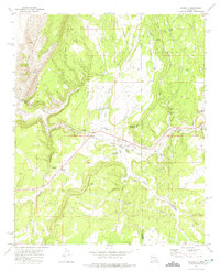
(31)- 1972 Map of Gran Quivira, 1975 Print
 1972 Gran Quivira1975 Print · USGSCentral New Mexico in the early seventies is defined here by the desert mesa and high plains near the county line. Researchers can trace the layout of the Gran Quivira National Monument and locate the Center Point School or Espinosa Lake.
 - 1972 Map of Chupadera, 1975 Print
 1972 Chupadera1975 Print · USGSThe high desert border of Torrance and Socorro counties is captured here in the early seventies, revealing a landscape of remote ranching and resource utility. Genealogists and historians can locate Chupadera Cem, the Fite Mine, and vital water sources like San Antonio Spring.
 - 1972 Map of Bigbee Draw, 1975 Print
 1972 Bigbee Draw1975 Print · USGSHigh-desert ranching territory in Torrance and Socorro counties is captured here during the early seventies. Researchers can trace land use through a network of remote sites like the Cain Ranch, Kerr Well, and the seasonal Brown Lake.
 - 1972 Map of Abo, 1975 Print
 1972 Abo1975 Print · USGSNew Mexico's high desert landscape comes into focus during the early seventies, centered on the ancient remains at Abo State Monument (Ruins). Trace the route of the Atchison Topeka and Santa Fe railroad or locate remote water sources like Wildcat Spring and Chilton Tank.
 - 1972 Map of Scholle, 1975 Print
 1972 Scholle1975 Print · USGSThe Manzano foothills and the critical transit corridor of Abo Canyon are captured here in the early seventies. Genealogists and historians can trace the rail-and-road economy through Scholle, the Abo Mine, and the Atchison Topeka and Santa Fe railroad.
 - 1972 Map of Mesa Draw, 1975 Print
 1972 Mesa Draw1975 Print · USGSRanching life in Torrance County during the early 1970s centered on the vital water sources scattered across the high mesas. Researchers can trace family history through sites like Cedar Grove Cem, Piñon Cem, and named landmarks such as Everhart Well and Eisenhart Hill.
 - 1972 Map of Rayo Hills, 1975 Print
 1972 Rayo Hills1975 Print · USGSCentral New Mexico in the early seventies remained a landscape of isolated ranching outposts and rugged desert terrain. Researchers can locate early water infrastructure like Brazil Windmill or track landmarks like U-Butte and Chupadera Gap.
 - 1972 Map of Round Top, 1975 Print
 1972 Round Top1975 Print · USGSTorrance County ranching life is well-documented in the 1970s, showcasing the high desert plateau and isolated homesteads. Genealogists can locate family landmarks like Round Top Cem, Liberty School, and High Lonesome Well.
 - 1978 Map of Waller Ranch
 1978 Waller Ranch1978 Print · USGSTorrance County ranching country is captured here in the mid-seventies, showing a landscape of scattered family holdings and high plains terrain. Researchers can trace the layout of the Waller Ranch and locate local landmarks like Red Hill or the area Gravel Pit.
 - 1978 Map of Milagro Spring
 1978 Milagro Spring1978 Print · USGSThe high plains of the Torrance and Guadalupe county line are documented here in the late seventies. Researchers can trace the essential water sources of the era, from Milagro Spring and Bales Lake to the rural Cemetery near Milagro Canyon.
 - 1978 Map of Laguna Del Perro North
 1978 Laguna Del Perro North1978 Print · USGSThe high salt plains of Torrance County are preserved here in the late seventies, showing a landscape defined by alkali basins and arid-land hydrology. Researchers can trace the sprawling boundaries of Laguna Del Perro (Salt) and locate smaller features like La Salina and a solitary Well.2 unique versions available
 - 1978 Map of Negra SW
 1978 Negra SW1978 Print · USGSTorrance County rangeland is captured here in the late seventies, showing the vast open landscape of central New Mexico. Researchers can trace the path of the Atchison Topeka and Santa Fe railroad and a significant southern Depression.
 - 1978 Map of Pedernal Mountain
 1978 Pedernal Mountain1978 Print · USGSTorrance County was undergoing subtle infrastructure shifts in the late seventies as industrial pipelines were laid across the high desert. Researchers can trace the path of the PIPELINE or locate natural features like Pedernal Mountain and Mc Gillivray Draw.
 - 1978 Map of Pedernal
 1978 Pedernal1978 Print · USGSTorrance County, New Mexico, is shown in the late 1970s as a quiet rail-centered landscape. Genealogists and historians can trace the path of the Atchison Topeka and Santa Fe through small stops like Pedernal and Dunmoor.
 - 1978 Map of North Lucy
 1978 North Lucy1978 Print · USGSTorrance County ranching and high-desert terrain are documented here in the late seventies. Researchers can trace the layout of North Lucy or locate family-named landmarks like Bigbee Ranch and the distinctive Landing Strip near Pintada Draw.
 - 1978 Map of Santa Barbara Lake
 1978 Santa Barbara Lake1978 Print · USGSThe high plains of eastern New Mexico are captured in the late seventies, showing a landscape of ranching and drainage basins. Researchers can trace the border between Torrance Co and Guadalupe Co near Santa Barbara Lake and Pinavete Canyon.
 - 1978 Map of Tejon
 1978 Tejon1978 Print · USGSThe high-desert border of Torrance and Guadalupe counties is captured here in the late 1970s, showcasing a landscape of critical transit infrastructure. Researchers can trace the junction of the Atchison Topeka and Santa Fe and Southern Pacific railroads near Tejon and Carnero.
 - 1978 Map of Santo Nino Canyon
 1978 Santo Nino Canyon1978 Print · USGSTorrance County ranching country is captured here during the late seventies, showing a landscape defined by deep canyons and critical water sources. Researchers can trace early rural life through isolated sites like Garcia Ranch, a lonely Grave, and numerous livestock tanks including Alvas Tank.
 - 1978 Map of Laguna Del Perro South
 1978 Laguna Del Perro South1978 Print · USGSThe high basins of Torrance County are captured here in the late 1970s, showcasing a landscape of ephemeral alkali lakes. Researchers can trace the path of the Atchison Topeka and Santa Fe railroad past the salt flats of Laguna Del Perro (Salt).
 - 1978 Map of Rock Lake
 1978 Rock Lake1978 Print · USGSTorrance County in the late seventies is characterized by its high-desert drainage basins and isolated water features. Genealogists and land researchers can trace property boundaries near Rock Lake, Texas Lake, and the winding Red Canyon floor.
 - 1978 Map of Encino
 1978 Encino1978 Print · USGSEncino sits at a critical junction of highway and rail in the 1970s, anchoring this portion of Torrance County. Genealogists and historians can locate the Guadalupe Cem, trace the Atchison Topeka and Santa Fe line, and explore the settlement at Carnero.
 - 1978 Map of Negra SE
 1978 Negra SE1978 Print · USGSThe open range of Torrance County was meticulously documented in the late 1970s, showing a land defined by geography rather than industry. Researchers can trace the path of a major Pipeline and identify natural catchment areas marked as Depression.
 - 1978 Map of Negra
 1978 Negra1978 Print · USGSHigh plains ranching and rail infrastructure define Torrance County in the late seventies. Genealogists and historians can locate the Cem near Negra or trace the path of the Atchison Topeka and Santa Fe railroad through the desert landscape.
 - 1978 Map of Lucy
 1978 Lucy1978 Print · USGSThe high-desert rail corridor of central New Mexico is captured here in the late seventies. Researchers can trace the path of the Atchison Topeka and Santa Fe through small settlements like Lucy and Culebra.
 - 1978 Map of Dunlap Ranch
 1978 Dunlap Ranch1978 Print · USGSHigh-desert ranching country in New Mexico is documented here in the late seventies, showing the sparse infrastructure of the plains. Trace the path of the A T & S F railroad through Carnero or locate the remote Dunlap Ranch.
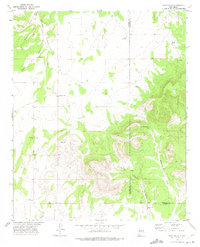
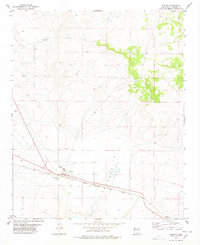
Showing maps 1-25 of 31
Top cities of Torrance County
- Moriarty historical maps
- Estancia historical maps
- Mountainair historical maps
- Willard historical maps
- Encino historical maps
- Johnny's Place historical maps
Frequently asked questions
- What are the different types of historical maps available for Torrance County?
- What is the oldest map of Torrance County?
- Where can I purchase historical maps of Torrance County for my home or office?
- Where can I download high-res historical maps of Torrance County?
- Are there historical topographic maps available for Torrance County?
- Is there historical aerial imagery available for Torrance County?
- Where are historical maps of Torrance County sourced from?