1940s Maps of Hoosick, New York
Explore 7 historic maps of Hoosick from the 1940s. These maps offer a rare glimpse into what life looked like during the 1940s — showing old roads, neighborhoods, homes, and landmarks that have changed or disappeared over time.
Whether you're researching your family's past, planning a metal detecting trip, or studying how Hoosick's landscape evolved across the 1940s, these high-resolution maps are a powerful tool for exploring the history of this region.
- Focus on a specific era: All maps on this page are from the 1940s, giving you a focused view of this time period.
- See what’s changed: Compare century-old streets, trails, and buildings to today's modern landscape using overlays and satellite layers.
- Research with precision: Use these maps for genealogy, historical research, land use analysis, or educational projects.
- View, download, or print: Maps are fully viewable online in high resolution, and can be downloaded or printed for your own records.
Start exploring Hoosick's history through authentic maps from the 1940s. This is your window into the past.
Hoosick, NY maps
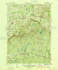
(7)- 1943 Map of Hoosick Falls, 1958 Print
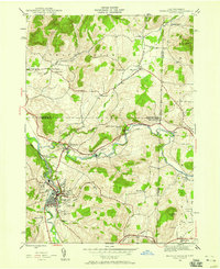 1943 Hoosick Falls1958 Print · USGSThe New York and Vermont borderlands come alive in this mid-century survey of the Hoosic and Walloomsac valleys. Trace the busy rail junctions of the Boston and Maine and locate historic sites like Bennington Battlefield Park and Sodom.4 unique versions available
 - 1944 Map of Eagle Bridge, 1958 Print
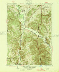
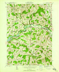 1944 Eagle Bridge1958 Print · USGSThe Hoosic River valley during the mid-1940s reveals a landscape defined by riverside rail corridors and upland farming hamlets. Genealogists can trace family roots through Woodside Cem, rural schoolhouses, and small settlements like Buskirk and West Hoosick.3 unique versions available
 - 1946 Map of Hoosick Falls
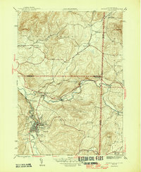 1946 Hoosick Falls1946 Print · USGSRensselaer County and the Vermont border are captured here just after the war, showing a landscape shaped by river valleys and early rail lines. Researchers can trace ancestral locations from Hoosick Falls to rural spots like Sodom, School No 5, and the St Marys Cem.2 unique versions available
 - 1946 Map of Eagle Bridge
 1946 Eagle Bridge1946 Print · USGSThe Hoosic River valley in the years following the war was a hub of small-town rail commerce and rural life. Genealogists and local historians can trace family roots through the clusters at Eagle Bridge, West Hoosick, and Center White Creek, or locate old landmarks like Woodside Cem and School No 2.2 unique versions available
 - 1946 Map of Grafton
 1946 Grafton1946 Print · USGSRensselaer County’s lake-strewn plateau is captured here in the mid-1940s, showing the early development of rural settlements and seasonal camps. Genealogists can locate family landmarks like the Warren Cem or trace old school districts such as Groveside Sch and Cobb Sch.2 unique versions available
 - 1946 Map of North Pownal
 1946 North Pownal1946 Print · USGSThe Hoosic River valley at the New York and Vermont border reveals a landscape shaped by mountain railroading and upland farming in the 1940s. Researchers can trace the intersection of the Rutland and Boston and Maine railroads near Petersburg Junction or locate rural landmarks like Gardner Cem and School No 11.2 unique versions available
 - 1948 Map of Albany, 1951 Print
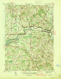
 1948 Albany1951 Print · USGSThe Hudson and Connecticut River valleys are captured here in the late 1940s, showing the vital rail and water corridors of the Northeast. You can trace the Boston and Maine tracks past Mt Greylock or locate early settlements like Great Barrington and Bennington.
End of results
Showing maps 1-7 of 7
Top cities near Hoosick
- North Adams historical maps
- Brunswick historical maps
- Stillwater historical maps
- Bennington historical maps
- Sand Lake historical maps
- Williamstown historical maps
See more
Top neighborhoods of Hoosick
- Buskirk historical maps
- Mapletown historical maps
- North Hoosick historical maps
- Walloomsac historical maps
- Eagle Bridge historical maps
- East Buskirk historical maps
See more
Frequently asked questions
- What are the different types of historical maps available for Hoosick?
- What is the oldest map of Hoosick?
- Where can I purchase historical maps of Hoosick for my home or office?
- Where can I download high-res historical maps of Hoosick?
- Are there historical topographic maps available for Hoosick?
- Is there historical aerial imagery available for Hoosick?
- Where are historical maps of Hoosick sourced from?