1990s Maps of Hoosick, New York
Explore 2 historic maps of Hoosick from the 1990s. These maps offer a rare glimpse into what life looked like during the 1990s — showing old roads, neighborhoods, homes, and landmarks that have changed or disappeared over time.
Whether you're researching your family's past, planning a metal detecting trip, or studying how Hoosick's landscape evolved across the 1990s, these high-resolution maps are a powerful tool for exploring the history of this region.
- Focus on a specific era: All maps on this page are from the 1990s, giving you a focused view of this time period.
- See what’s changed: Compare century-old streets, trails, and buildings to today's modern landscape using overlays and satellite layers.
- Research with precision: Use these maps for genealogy, historical research, land use analysis, or educational projects.
- View, download, or print: Maps are fully viewable online in high resolution, and can be downloaded or printed for your own records.
Start exploring Hoosick's history through authentic maps from the 1990s. This is your window into the past.
Hoosick, NY maps
(2)- 1995 Map of North Pownal, 2000 Print
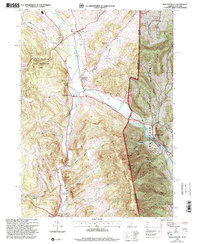 1995 North Pownal2000 Print · USGSThe borderlands of New York and Vermont come alive in the 1990s, where the Hoosic River cuts between the Taconic and Green Mountains. Trace local heritage through rural landmarks like Petersburg Junction, the Gardner Cem, and Hoosick Sch.
 - 1995 Map of Hoosick Falls, 2000 Print
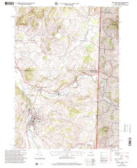 1995 Hoosick Falls2000 Print · USGSThe Rensselaer County borderlands come alive in the mid-nineties as small settlements and rail junctions follow the winding river valleys into Vermont. Researchers can trace family sites from St Marys Ch to rural outposts like Post Corners and Center White Creek.
End of results
Showing maps 1-2 of 2
Top cities near Hoosick
- North Adams historical maps
- Brunswick historical maps
- Stillwater historical maps
- Bennington historical maps
- Sand Lake historical maps
- Williamstown historical maps
See more
Top neighborhoods of Hoosick
- Buskirk historical maps
- Mapletown historical maps
- North Hoosick historical maps
- Walloomsac historical maps
- Eagle Bridge historical maps
- East Buskirk historical maps
See more
Frequently asked questions
- What are the different types of historical maps available for Hoosick?
- What is the oldest map of Hoosick?
- Where can I purchase historical maps of Hoosick for my home or office?
- Where can I download high-res historical maps of Hoosick?
- Are there historical topographic maps available for Hoosick?
- Is there historical aerial imagery available for Hoosick?
- Where are historical maps of Hoosick sourced from?