1980s Maps of Columbus County, North Carolina
Explore 20 historic maps of Columbus County from the 1980s. These maps offer a rare glimpse into what life looked like during the 1980s — showing old roads, neighborhoods, homes, and landmarks that have changed or disappeared over time.
Whether you're researching your family's past, planning a metal detecting trip, or studying how Columbus County's landscape evolved across the 1980s, these high-resolution maps are a powerful tool for exploring the history of this region.
- Focus on a specific era: All maps on this page are from the 1980s, giving you a focused view of this time period.
- See what’s changed: Compare century-old streets, trails, and buildings to today's modern landscape using overlays and satellite layers.
- Research with precision: Use these maps for genealogy, historical research, land use analysis, or educational projects.
- View, download, or print: Maps are fully viewable online in high resolution, and can be downloaded or printed for your own records.
Start exploring Columbus County's history through authentic maps from the 1980s. This is your window into the past.
Columbus County, NC maps
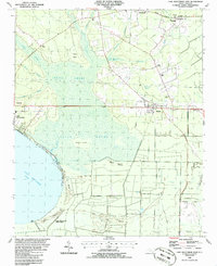
(20)- 1980 Map of Acme, 1985 Print
 1980 Acme1985 Print · USGSCoastal North Carolina industrial and rail corridors are captured in this early 1980s infrared survey of the lower Cape Fear region. Researchers can trace the development of Riegelwood and the historic railway hamlets of Delco, Acme, and Maco.
 - 1980 Map of Lewis Swamp, 1985 Print
 1980 Lewis Swamp1985 Print · USGSCoastal North Carolina's rural landscape is revealed in this 1980 color infrared study of the wetlands and timberlands. Researchers can trace remote crossroads and family-named locales such as Rabontown, Flowers Corner, and the depths of Green Swamp.
 - 1980 Map of Point Caswell, 1985 Print
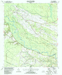
 1980 Point Caswell1985 Print · USGSThe riverine landscapes of Pender County are captured in this color infrared aerial survey from the early 1980s. Local researchers can trace family lands and rural property boundaries near Point Caswell, Long View, and the winding banks of the Black River.
 - 1983 Map of Point Caswell, 1984 Print
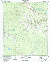
 1983 Point Caswell1984 Print · USGSThe river-and-swamp country of Pender and Bladen Counties is captured here in the early 1980s. Genealogists can trace family landmarks like Haw Bluff Ch, Rosa Green Ch, and the Moore Cem along the winding BLACK RIVER.
 - 1983 Map of Florence, 1985 Print
 1983 Florence1985 Print · USGSThe Pee Dee region in the early eighties shows a landscape shaped by river commerce and rail expansion. Researchers can trace historic river crossings at Galivants Ferry or locate vanished rail stops like Willow Creek Siding and Blue Brick.
 - 1984 Map of Acme
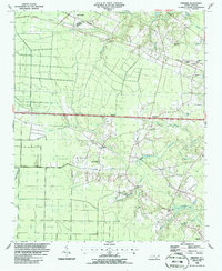
 1984 Acme1984 Print · USGSCoastal North Carolina settlements at the confluence of three counties are captured here in the early eighties. Genealogists and local historians can trace family roots through numerous landmarks like Sykes Cemetery, Farmers Chapel, and the Acme-Delco School.
 - 1986 Map of Lake Waccamaw East
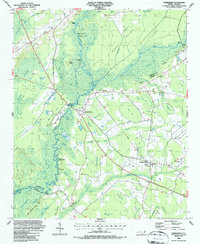
 1986 Lake Waccamaw East1986 Print · USGSCoastal plain wetlands and small-town rail corridors define this mid-1980s look at Columbus County. Researchers can trace the Seaboard System tracks through Bolton and locate family landmarks like Union Chapel and Goose Hollow.
 - 1986 Map of Freeman
 1986 Freeman1986 Print · USGSSoutheastern North Carolina in the mid-1980s reveals a landscape of rural communities and railroad corridors along the Bladen and Columbus county line. Genealogists can trace family footprints through numerous country churches and cemeteries near Byrdville, Freeman, and East Arcadia.
 - 1986 Map of Kelly
 1986 Kelly1986 Print · USGSThe Cape Fear River valley in the mid-1980s reveals a landscape of river-crossing ferries and swamp-land canals. Researchers can trace rural community roots through the Elwells Ferry crossing, the Bladen Technical College campus, and local settlements like Kelly and East Arcadia.
 - 1986 Map of Council
 1986 Council1986 Print · USGSThe rural landscapes of Bladen and Columbus counties are captured here in the mid-1980s, centered on the rail-side community of Council. Researchers can trace old family landmarks and local gathering places like McEwen Cem, Zion Ch, and the waters of Meares Millpond.
 - 1986 Map of Whiteville
 1986 Whiteville1986 Print · USGSSoutheastern North Carolina and the South Carolina borderlands are captured here in the mid-1980s as a landscape of vast swamps and rail towns. Researchers can trace historic rail routes through Chadbourn, locate the namesake Lake Waccamaw, and explore family-named sites like Peacocks.
 - 1986 Map of Myrtle Beach
 1986 Myrtle Beach1986 Print · USGSThe Grand Strand and Brunswick County coast are captured in the mid-eighties before the late-century development boom. Researchers can trace the footprint of the Myrtle Beach Air Force Base and old coastal settlements like Atlantic Beach and Socastee.
 - 1986 Map of Chadbourn, 1987 Print
 1986 Chadbourn1987 Print · USGSCoastal plain settlements and expansive wetlands define the Chadbourn area in the mid-eighties. Researchers can locate family-named landmarks and rural hubs like Powells Crossing, Southeastern Community College, and the Belle View Cem.
 - 1986 Map of Evergreen, 1987 Print
 1986 Evergreen1987 Print · USGSCoastal plain wetlands and small rail-side communities define this mid-1980s survey of the Columbus County border. Researchers can trace family roots at Mt Elam Ch or locate the old Seaboard Coast Line tracks near Boardman and Evergreen.
 - 1986 Map of Cerro Gordo, 1987 Print
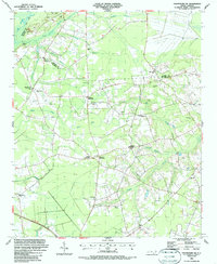
 1986 Cerro Gordo1987 Print · USGSCoastal plain settlements and railroad hamlets in Columbus County are captured here in the mid-1980s. Researchers can trace family history through local landmarks like Williamson Crossroads, Porter Swamp Ch, and Regar Cem.
 - 1986 Map of Chadbourn NE, 1987 Print
 1986 Chadbourn NE1987 Print · USGSCoastal Plain wetlands and rural crossroads define this corner of Columbus County in the late eighties. Genealogists can trace family lines through numerous sites like Benevolent Cem and Lennons Crossroads, or locate Atkinson Temple and Horsepen Landing.
 - 1987 Map of Clarkton
 1987 Clarkton1987 Print · USGSThe borderlands of Bladen and Columbus Counties come into focus during the late 1980s, centered on the railroad town of Clarkton. Genealogists and historians can trace numerous rural congregations and landmarks, from Graham Tabernacle and St James Ch to the small community at Wootens Crossroad.
 - 1987 Map of Emerson
 1987 Emerson1987 Print · USGSCoastal plain wetlands and small rail-side communities define this North Carolina landscape in the late 1980s. Genealogists and historians can locate rural landmarks like Old Bethel Cem, White Plains Ch, and the many Carolina bays like Chancy Bay.
 - 1987 Map of Lake Waccamaw West
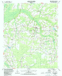
 1987 Lake Waccamaw West1987 Print · USGSCoastal plains and deep swamps define Columbus County in the late eighties, where the railroad corridor links small communities above the waterline. Trace family history at Hallsboro High Sch, Pierce Cem, or Mount Olive Ch near the banks of Lake Waccamaw.
 - 1987 Map of Whiteville
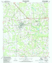
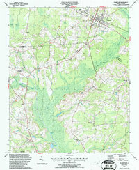
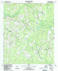
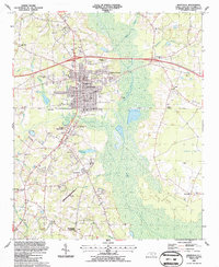 1987 Whiteville1987 Print · USGSWhiteville and its surrounding swamps are captured in the late 1980s as a community defined by its civic heart and coastal wetlands. Researchers can trace family sites near Whiteville Cem, old rail lines like the Old RR Grade, and rural outposts at Halls or Honey Hill.
End of results
Showing maps 1-20 of 20
Top cities of Columbus County
- Whiteville historical maps
- Tabor City historical maps
- Chadbourn historical maps
- Lake Waccamaw historical maps
- Fair Bluff historical maps
- Bolton historical maps
See more
Frequently asked questions
- What are the different types of historical maps available for Columbus County?
- What is the oldest map of Columbus County?
- Where can I purchase historical maps of Columbus County for my home or office?
- Where can I download high-res historical maps of Columbus County?
- Are there historical topographic maps available for Columbus County?
- Is there historical aerial imagery available for Columbus County?
- Where are historical maps of Columbus County sourced from?