Old Maps of Mountrail County, North Dakota for Metal Detecting
Plan your next treasure hunt with 378 historic maps of Mountrail County. Find old homesites, ghost towns, trails, and gathering spots that may be lost to time — perfect for identifying promising metal detecting locations.
- Locate forgotten sites: Uncover places like long-lost settlements, abandoned rail lines, or gathering spots.
- Plan better hunts: Use map overlays combined with LiDAR or satellite views to narrow in on historically rich areas.
- Made for detectorists: Thousands of hobbyists use these maps to discover relics, coins, and hidden history.
Use these historic maps to boost your research and find new opportunities beneath the surface of Mountrail County.
Mountrail County, ND maps
(378)- 1947 Map of Tolley, 1963 Print
 1947 Tolley1963 Print · USGSThe North Dakota prairie near the Mouse River comes to life in this post-war survey of Renville and Ward Counties. Genealogists and local historians can trace rural school locations and family burial sites like Greenbush Cem or St Anthony Cem, while tracking the path of the Great Northern railroad.
 - 1948 Map of Donnybrook
 1948 Donnybrook1948 Print · USGSDonnybrook was a bustling rail hub in the late 1940s where two major lines intersected along the Des Lacs River. Genealogists can locate several rural landmarks including Odd Fellows Cem, Church Hill, and a network of numbered district schools.
 - 1949 Map of Mosquito Butte
 1949 Mosquito Butte1949 Print · USGSThe North Dakota prairie near the Burke, Ward, and Mountrail county lines is captured here in the late 1940s. Genealogists and local historians can locate early landmarks like Buck Sch and Bethlehem Ch or trace the drainage of Christensen Slough.
 - 1949 Map of Coulee
 1949 Coulee1949 Print · USGSThe North Dakota prairie meets the steep draws of the Des Lacs valley in the late 1940s. Genealogists can trace early rural life through several local landmarks like Crowfoot Sch, Lowland Sch, and the small siding at Baden.
 - 1950 Map of Kenmare
 1950 Kenmare1950 Print · USGSKenmare and the surrounding prairies are captured here at mid-century, dominated by the long ribbon of the Des Lacs lakes. Local researchers can trace rural life through numerous country schoolhouses and churches, including Buck Sch, Our Savior Ch, and the Kenmare Landing Field.2 unique versions available
 - 1950 Map of Tolley
 1950 Tolley1950 Print · USGSRenville and Ward Counties are captured here mid-century, showcasing the vital rail-and-river economy of the northern plains. Local researchers can trace the locations of rural schoolhouses and family burial sites like Trinity Cem and Odd Fellows Cem near Tolley and Donnybrook.
 - 1953 Map of Williston, 1968 Print
 1953 Williston1968 Print · USGSThe North Dakota high plains meet the waters of Sakakawea Lake in this mid-century survey of the northern borderlands. Trace the rail-and-ranch economy through sites like Anderson Sky Ranch, Sevenmile Corner, and the strip mines near Columbus.2 unique versions available
 - 1953 Map of Watford City, 1968 Print
 1953 Watford City1968 Print · USGSNorth Dakota's badlands and the Missouri River basin are captured here during the 1950s and 60s as the Garrison Dam changed the landscape. Researchers can trace old rail lines like the Great Northern or find rural outposts such as Grassy Butte and Halliday.3 unique versions available
 - 1954 Map of Minot, 1964 Print
 1954 Minot1964 Print · USGSNorth Dakota's northern borderlands are captured here in the mid-fifties, showing a landscape defined by the winding Souris River and the rise of the Turtle Mountains. Genealogists can locate family-named sidings like Hurd Siding and Truro Siding alongside the vital Great Northern rail lines.3 unique versions available
 - 1954 Map of McClusky, 1968 Print
 1954 McClusky1968 Print · USGSCentral North Dakota was undergoing a profound transformation in the fifties as the newly formed Lake Sakakawea reshaped the Missouri River valley. Genealogists and historians can trace rail-town development along the Soo Line and locate historic markers like Garrison Dam or the Lewis and Clark Trail.3 unique versions available
 - 1956 Map of Makoti SW
 1956 Makoti SW1956 Print · USGSThe McLean and Mountrail county border in the mid-1950s is captured here, showing a landscape of prairie potholes and rural outposts. Researchers can locate family landmarks like the Bethlehem Ch, Roseglen Cem, and the Wright Sch.
 - 1956 Map of Roseglen, 1958 Print
 1956 Roseglen1958 Print · USGSMcLean County in the mid-fifties presents a quiet landscape of prairie townships and conservation land. Genealogists and historians can trace the rural school system and the Old Indian Boundary near Roseglen and the Hiddenwood Cem.2 unique versions available
 - 1957 Map of Williston
 1957 Williston1957 Print · USGSNorthwestern North Dakota is shown here during the mid-fifties, dominated by the sweeping plains and the Missouri River valley. Genealogists and local historians can trace the paths of the Great Northern railroad through Williston, Tioga, and Ray, or locate early industry like the coal strip mines near Lignite.
 - 1957 Map of Watford City
 1957 Watford City1957 Print · USGSWestern North Dakota's landscape is captured here during the mid-fifties as the Missouri River valley undergoes massive change following the creation of Garrison Reservoir. Genealogists and historians can trace dozens of rural schools like Divide School and early settlements such as Arnegard and Grassy Butte.
 - 1958 Map of McClusky
 1958 McClusky1958 Print · USGSCentral North Dakota was undergoing a profound change in the late fifties as the Garrison Reservoir filled behind its massive new dam. Trace the early layout of Riverdale, the Lewis and Clark Trail, and the vanishing rail stops of the Northern Pacific.
 - 1958 Map of Minot
 1958 Minot1958 Print · USGSNorthern North Dakota is shown here during the mid-fifties, dominated by the rail-driven growth of Minot and the surrounding grain-farming prairie. Genealogists can trace family connections to border towns like Westhope or explore the vast reaches of the Turtle Mountains.
 - 1965 Map of Charlson, 1966 Print
 1965 Charlson1966 Print · USGSMcKenzie County in the mid-1960s reveals a prairie landscape transitioning into an industrial energy hub. Genealogists and historians can locate the Charlson settlement, remote burial sites like Riverside Cem, and the extensive Oil and Gas Field.
 - 1965 Map of Charlson NE, 1967 Print
 1965 Charlson NE1967 Print · USGSMountrail and Williams Counties meet at the edge of the Garrison Reservoir during the mid-sixties. Researchers can trace the original path of the Missouri River and explore terrain features like Dry Fork and Elm Tree.
 - 1967 Map of Watford City
 1967 Watford City1967 Print · USGSWestern North Dakota is captured during a period of landscape transformation as the Missouri River valley was reshaped by the new Garrison Reservoir. Genealogists and local historians can trace the foundations of Watford City, find the Elkhorn Ranch Site, or locate rural landmarks like Ziner Butte and Grassy Butte.
 - 1967 Map of Sanish NW, 1969 Print
 1967 Sanish NW1969 Print · USGSThe Fort Berthold Indian Reservation and the Missouri River highlight this North Dakota landscape in the late sixties as the water levels rose. Genealogists and local researchers can locate the Snowbird Chapel, Goodbird Cem, and the sprawling Antelope Oil Field.
 - 1967 Map of Sanish, 1969 Print
 1967 Sanish1969 Print · USGSThe Missouri River valley in the late sixties reveals a landscape transformed by the waters of Lake Sakakawea along the Fort Berthold Indian Reservation boundary. Genealogists and local historians can trace the foundations of Sanish, locate the Riverview Cemetery, and follow the path of an Old Railroad Grade.2 unique versions available
 - 1967 Map of Sanish SE, 1969 Print
 1967 Sanish SE1969 Print · USGSThe Missouri River breaks in Mountrail County are shown during a transformative era in the late sixties as the reservoir fills the valley. Researchers can trace the Fort Berthold Indian Reservation Boundary and locate Shell Creek Ch and the Little Shell Creek Public Use Area.
 - 1967 Map of New Town SW, 1970 Print
 1967 New Town SW1970 Print · USGSMountrail County's shoreline was dramatically reshaped by the mid-1960s as the Missouri River valley transitioned into a vast reservoir. Researchers can trace the Fort Berthold Indian Reservation Boundary and locate local landmarks like Little Shell Ch and the Van Hook State Game Management Area.
 - 1967 Map of Sanish SW, 1970 Print
 1967 Sanish SW1970 Print · USGSMcKenzie County's badlands terrain meets the rising waters of the Missouri River in the late sixties. Trace the inundated shoreline of Lake Sakakawea and find landmarks like Blue Butte or the Bear Den Creek Public Use Area.
 - 1967 Map of Parshall SE, 1970 Print
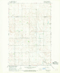 1967 Parshall SE1970 Print · USGSThe rural landscapes of McLean and Mountrail counties are captured here in the late 1960s as part of the Missouri River Basin development. Genealogists can trace local landmarks such as the Lucky Mound Ch and the Church of God Cem among the townships.
Showing maps 1-25 of 378
Top cities of Mountrail County
- New Town historical maps
- Stanley historical maps
- Plaza historical maps
- Palermo historical maps
- White Earth historical maps
- Manitou historical maps
See more
Frequently asked questions
- What are the different types of historical maps available for Mountrail County?
- What is the oldest map of Mountrail County?
- Where can I purchase historical maps of Mountrail County for my home or office?
- Where can I download high-res historical maps of Mountrail County?
- Are there historical topographic maps available for Mountrail County?
- Is there historical aerial imagery available for Mountrail County?
- Where are historical maps of Mountrail County sourced from?