1960s Maps of Put-in-Bay Township, Ohio
Explore 5 historic maps of Put-in-Bay Township from the 1960s. These maps offer a rare glimpse into what life looked like during the 1960s — showing old roads, neighborhoods, homes, and landmarks that have changed or disappeared over time.
Whether you're researching your family's past, planning a metal detecting trip, or studying how Put-in-Bay Township's landscape evolved across the 1960s, these high-resolution maps are a powerful tool for exploring the history of this region.
- Focus on a specific era: All maps on this page are from the 1960s, giving you a focused view of this time period.
- See what’s changed: Compare century-old streets, trails, and buildings to today's modern landscape using overlays and satellite layers.
- Research with precision: Use these maps for genealogy, historical research, land use analysis, or educational projects.
- View, download, or print: Maps are fully viewable online in high resolution, and can be downloaded or printed for your own records.
Start exploring Put-in-Bay Township's history through authentic maps from the 1960s. This is your window into the past.
Put-in-Bay Township, OH maps
(5)- 1961 Map of Toledo
 1961 Toledo1961 Print · USGSThe western basin of Lake Erie and the industrial heart of Northern Ohio are captured here during the post-war era. Researchers can trace historical rail lines like the New York Central or locate landmarks like the Erie Ordnance Depot and Pelee Island.
 - 1964 Map of Metzger Marsh, 1965 Print
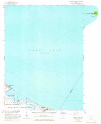 1964 Metzger Marsh1965 Print · USGSCoastal Lucas County in the mid-1960s was a sanctuary of protected marshlands and quiet lakeside reaches. Trace the shoreline through the Metzger Marsh Wildlife Area to the remote West Sister Island and the residential pocket of Howard Farms Beach.
 - 1969 Map of Put-In-Bay, 1971 Print
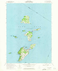 1969 Put-In-Bay1971 Print · USGSThe Bass Islands of Lake Erie appear in the late sixties as a thriving maritime community and summer destination. Genealogists and historians can trace local landmarks like St Pauls Ch, Middle Bass Sch, and the grounds of South Bass Island State Park.
 - 1969 Map of Gypsum, 1971 Print
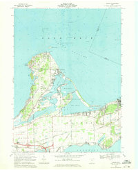 1969 Gypsum1971 Print · USGSCatawba Island and the Marblehead Peninsula are shown here in the late sixties as both a vacation destination and an industrial hub. Researchers can trace family sites at Sackett Cem, the massive Marblehead Quarry, and the community of Lakeside.3 unique versions available
 - 1969 Map of Port Clinton, 1971 Print
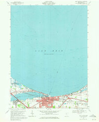 1969 Port Clinton1971 Print · USGSPort Clinton sits at the mouth of the Portage River during a period of steady shoreline growth and industrial activity. Genealogists and local historians can trace family markers at Lakeview Cem, explore the rail layout of the Penn Central, or locate the old Drive-in Theater.
End of results
Showing maps 1-5 of 5
Top cities near Put-in-Bay Township
- Sandusky historical maps
- Port Clinton historical maps
- Catawba Island historical maps
- Oak Harbor historical maps
- Marblehead historical maps
- Kelleys Island historical maps
See more
Top neighborhoods of Put-in-Bay Township
- Isle Saint George historical maps
- Middle Bass historical maps
- Put-in-Bay historical maps
- East Point historical maps
- Island Bay Estates historical maps
- Lakeview Allotment historical maps
See more
Frequently asked questions
- What are the different types of historical maps available for Put-in-Bay Township?
- What is the oldest map of Put-in-Bay Township?
- Where can I purchase historical maps of Put-in-Bay Township for my home or office?
- Where can I download high-res historical maps of Put-in-Bay Township?
- Are there historical topographic maps available for Put-in-Bay Township?
- Is there historical aerial imagery available for Put-in-Bay Township?
- Where are historical maps of Put-in-Bay Township sourced from?