Old Maps of Milton Center, Ohio for Academic Research
Study the evolution of Milton Center with 10 high-resolution historic maps. Whether you're teaching, researching, or modeling changes in land use, these maps provide essential visual documentation of urban, environmental, and geographic change.
- Analyze long-term change: Track patterns in development, transportation, and natural features.
- Ideal for environmental or urban studies: Support academic projects with primary historical map data.
- Use in the classroom or lab: Educators and researchers rely on these maps to bring historical context to life.
These maps are a powerful tool for teaching, research, and visualizing how Milton Center has changed over the decades.
Milton Center, OH maps
(10)- 1909 Map of Mc Clure, 1936 Print
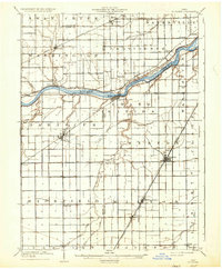 1909 Mc Clure1936 Print · USGSNorthwest Ohio's agricultural and transit heartland is captured here at the start of the twentieth century. Genealogists and rail historians can trace the paths of the Wabash RR and the Electric Detroit and Toledo Line as they connected towns like Mc Clure and Weston.2 unique versions available
 - 1956 Map of Toledo, 1968 Print
 1956 Toledo1968 Print · USGSNorthwest Ohio and the Lake Erie shoreline are shown in detail during the late fifties, showcasing a landscape of heavy industry, railroads, and island communities. Genealogists and historians can trace rail networks like the Chesapeake & Ohio RR or locate landmarks such as the Erie Proving Ground and Kelleys Island.4 unique versions available
 - 1960 Map of Weston, 1961 Print
 1960 Weston1961 Print · USGSWood County farmland transitions into the town of Weston at the start of the sixties, centered on the vital Baltimore and Ohio rail line. Researchers can trace rural lineages through the St Louis Cem and Pottertown Cem or follow the unique geography of the Sand Ridge.3 unique versions available
 - 1961 Map of Toledo
 1961 Toledo1961 Print · USGSThe western basin of Lake Erie and the industrial heart of Northern Ohio are captured here during the post-war era. Researchers can trace historical rail lines like the New York Central or locate landmarks like the Erie Ordnance Depot and Pelee Island.
 - 1986 Map of Findlay
 1986 Findlay1986 Print · USGSNorthwest Ohio's industrial and agricultural heartland is documented here in the mid-1980s, centered on the major hubs of Findlay, Fostoria, and Tiffin. Researchers can trace the intersections of the BALTIMORE AND OHIO railroad and family sites near Greenlawn Cem or Sagar Ridge.2 unique versions available
 - 2010 Map of Weston, 2010 Print
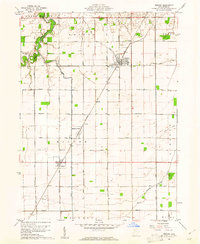
 2010 Weston2010 Print · USGSCovers Milton Center, including Weston, Custar, and other nearby areas
 - 2013 Map of Weston, 2013 Print
 2013 Weston2013 Print · USGSCovers Milton Center, including Weston, Custar, and other nearby areas
 - 2016 Map of Weston, 2016 Print
 2016 Weston2016 Print · USGSCovers Milton Center, including Weston, Custar, and other nearby areas
 - 2019 Map of Weston, 2019 Print
 2019 Weston2019 Print · USGSCovers Milton Center, including Weston, Custar, and other nearby areas
 - 2023 Map of Weston, 2023 Print
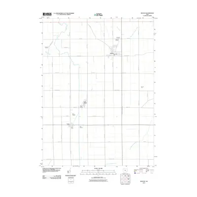
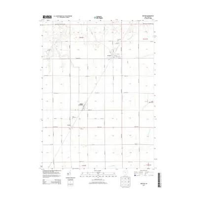
 2023 Weston2023 Print · USGSWeston and Milton Center are shown in the 2020s amidst the highly structured agricultural landscape of Wood County. Researchers can trace historic burial sites like Old Weston Cem and Pottertown Cem or follow the path of the North Branch Portage River.
End of results
Showing maps 1-10 of 10
Top cities near Milton Center
- Findlay historical maps
- Bowling Green historical maps
- Perrysburg historical maps
- Waterville historical maps
- Providence historical maps
- Whitehouse historical maps
See more
Frequently asked questions
- What are the different types of historical maps available for Milton Center?
- What is the oldest map of Milton Center?
- Where can I purchase historical maps of Milton Center for my home or office?
- Where can I download high-res historical maps of Milton Center?
- Are there historical topographic maps available for Milton Center?
- Is there historical aerial imagery available for Milton Center?
- Where are historical maps of Milton Center sourced from?