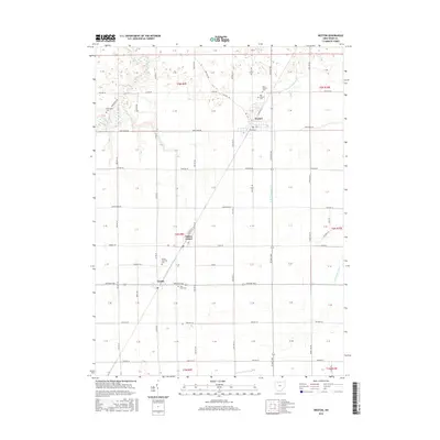
2016 Map of Weston
USGS Topo · Published 2016About this map
Weston serves as a central hub in this western Wood County landscape, where the geometry of the township and range system is punctuated by small agricultural settlements. The terrain is defined by a series of drainage networks, including the meandering paths of W Br Tontogany Cr and Sugar Cr, which break the rigid grid of county roads. Further south, the village of Milton Center and the community of Custar sit along the north-south transport corridors, maintaining their local identity amidst expansive farm tracts. For those researching local ancestry, the map identifies several burial grounds such as Old Weston Cem and the Milton Township Cem. These sites, along with the Saint Louis Cem near Custar, provide critical anchors for tracing family lineages in this rural Ohio heartland. The layout of roads like Sand Ridge Rd and Defiance Pike illustrates the enduring infrastructure that has supported this region's farming economy for generations.
Find a feature on this map
83 named features on this map. Tap any name to fly to it.
Don’t see what you’re looking for? This feature index may not catch every label — zoom into the map to look around manually.
Map Details
Editions of this 2016 Weston Map
This is the sole edition of this map. No revisions or reprints were ever made.
Other maps of this area

1901 · Bowling Green
USGS Topo · 1:62,500

1903 · Bowling Green
USGS Topo · 1:62,500

1903 · Findlay
USGS Topo · 1:62,500

1909 · Mc Clure
USGS Topo · 1:62,500

1935 · Grand Rapids
USGS Topo · 1:24,000
1938 · Tontogany
USGS Topo · 1:31,680

1940 · Grand Rapids
USGS Topo · 1:31,680
1952 · Tontogany
USGS Topo · 1:24,000
1952 · Grand Rapids
USGS Topo · 1:24,000

1956 · Toledo
USGS Topo · 1:250,000