1960s Maps of Caddo County, Oklahoma
Explore 11 historic maps of Caddo County from the 1960s. These maps offer a rare glimpse into what life looked like during the 1960s — showing old roads, neighborhoods, homes, and landmarks that have changed or disappeared over time.
Whether you're researching your family's past, planning a metal detecting trip, or studying how Caddo County's landscape evolved across the 1960s, these high-resolution maps are a powerful tool for exploring the history of this region.
- Focus on a specific era: All maps on this page are from the 1960s, giving you a focused view of this time period.
- See what’s changed: Compare century-old streets, trails, and buildings to today's modern landscape using overlays and satellite layers.
- Research with precision: Use these maps for genealogy, historical research, land use analysis, or educational projects.
- View, download, or print: Maps are fully viewable online in high resolution, and can be downloaded or printed for your own records.
Start exploring Caddo County's history through authentic maps from the 1960s. This is your window into the past.
Caddo County, OK maps
(11)- 1961 Map of Eakly, 1962 Print
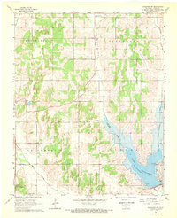
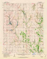 1961 Eakly1962 Print · USGSSettlement and farming patterns in central Oklahoma are captured here in the early sixties, just as the Fort Cobb Reservoir began to transform the local drainage. Genealogists and historians can locate numerous rural burial grounds and meeting houses, including Missouri Cem Ch, High Point Cem, and the Indian Cem.2 unique versions available
 - 1961 Map of Carnegie, 1963 Print
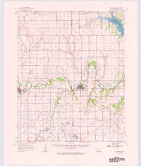 1961 Carnegie1963 Print · USGSThe Washita River valley in the early sixties serves as the focal point for this survey of Carnegie and Mountain View. Genealogists can trace family names at Indian Mission, Cedar Creek Cem, or the Old Indian Treaty Boundary.
 - 1964 Map of Weatherford, 1966 Print
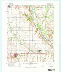 1964 Weatherford1966 Print · USGSWestern Oklahoma life in the mid-sixties centers on the busy railroad corridors and the winding course of the Canadian River. Researchers can trace old family sites like Mound Olive Cem, the Indian Mission Ch, and the evocative Dead Women Crossing.
 - 1967 Map of Cogar, 1969 Print
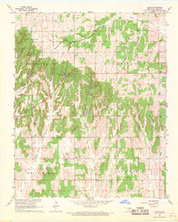 1967 Cogar1969 Print · USGSCaddo County's rural landscape comes into focus during the late 1960s, centered on the small community of Cogar. Genealogists and local historians can locate several country churches, the Spring Creek Cem, and family-named landmarks like Salyer Lake.2 unique versions available
 - 1967 Map of Cogar NW, 1970 Print
 1967 Cogar NW1970 Print · USGSThe braided channel of the Canadian River dominates this late-1960s rural landscape on the Caddo and Canadian county line. Genealogists and local historians can trace the foundations of the community at Niles Cem, East Walnut Sch, and Cedar Lake.
 - 1968 Map of Cogar SE, 1969 Print
 1968 Cogar SE1969 Print · USGSCaddo and Grady counties are documented here in the late sixties, showcasing a landscape defined by creek drainages and section-line roads. Researchers can locate rural landmarks such as Hazel Dell Ch, Center View Cem, and the Canadian River bend.
 - 1968 Map of Anadarko NE, 1969 Print
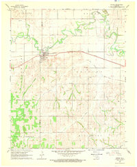
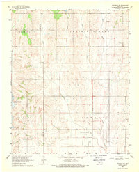 1968 Anadarko NE1969 Print · USGSGrady and Caddo Counties are captured here in the late sixties, showing a landscape of rural homesteads and emerging energy production. Researchers can locate the settlement of Dutton and trace family sites near Friendship Ch or the Northeast Verden Oil Field.
 - 1968 Map of Cogar NE, 1969 Print
 1968 Cogar NE1969 Print · USGSThe Canadian River valley and the rural edges of El Reno and Union City are captured in this late sixties survey. Genealogists can locate Buena Vista Cem, Heaston Ch, and family landmarks across Maple Prairie.2 unique versions available
 - 1968 Map of Anadarko NW, 1969 Print
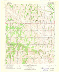
 1968 Anadarko NW1969 Print · USGSCaddo County in the late sixties reveals a landscape shaped by water management and mission history. Genealogists can locate the Wichita Mission, while recreational sites like Lake Chickasha and Spring Creek Ch mark the changing social geography.2 unique versions available
 - 1968 Map of Verden, 1969 Print
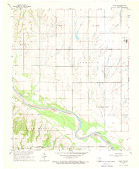
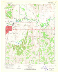
 1968 Verden1969 Print · USGSThe town of Verden and the winding Washita River define this Oklahoma landscape in the late sixties. Researchers can trace the path of the Chicago Rock Island and Pacific railroad or locate local landmarks like the Mennonite Ch and Elderberry Ch.
 - 1968 Map of Anadarko East, 1970 Print
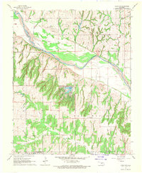
 1968 Anadarko East1970 Print · USGSAnadarko and the Washita River valley are captured in the late sixties, showing the town at a peak of mid-century growth. Researchers can trace local history at the Indian Museum, the Fairground, and legacy sites like Kiowa Cem or New Hope Ch.
End of results
Showing maps 1-11 of 11
Top cities of Caddo County
- Anadarko historical maps
- Hinton historical maps
- Carnegie historical maps
- Apache historical maps
- Cyril historical maps
- Fort Cobb historical maps
See more
Frequently asked questions
- What are the different types of historical maps available for Caddo County?
- What is the oldest map of Caddo County?
- Where can I purchase historical maps of Caddo County for my home or office?
- Where can I download high-res historical maps of Caddo County?
- Are there historical topographic maps available for Caddo County?
- Is there historical aerial imagery available for Caddo County?
- Where are historical maps of Caddo County sourced from?