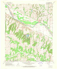
1967 Map of Cogar NW
USGS Topo · Published 1970About this map
The Canadian River carves a broad, braided path across this central Oklahoma landscape, defining the county line between Canadian and Caddo Counties. The terrain shifts from the wide river valley into a complex network of eroded drainages and ridges, including Bear Canyon and the uplands of Walnut and East Walnut. This late-1960s survey documents a rural environment shaped by natural water sources and early-century civic infrastructure. Landmarks such as Cedar Lake provide a focal point for the community, while the presence of Niles Cem and the East Walnut Sch suggests the locations of established local settlements. Resource extraction is evident through scattered Gravel Pits and various Gas Well sites, which are interspersed with agricultural field lines and small outposts like Red Hill.
Find a feature on this map
18 named features on this map. Tap any name to fly to it.
Don’t see what you’re looking for? This feature index may not catch every label — zoom into the map to look around manually.
Map Details
Editions of this 1967 Cogar NW Map
This is the sole edition of this map. No revisions or reprints were ever made.
Other maps of this area

1893 · Fort Reno
USGS Topo · 1:62,500

1893 · Buggy Creek
USGS Topo · 1:62,500

1941 · Fort Reno
USGS Topo · 1:62,500

1942 · Fort Reno
USGS Topo · 1:62,500

1942 · Geary
USGS Topo · 1:62,500

1949 · Fort Reno
USGS Topo · 1:62,500

1951 · Binger
USGS Topo · 1:62,500

1955 · Clinton
USGS Topo · 1:250,000

1957 · Clinton
USGS Topo · 1:250,000

1967 · Fort Reno SW
USGS Topo · 1:24,000