
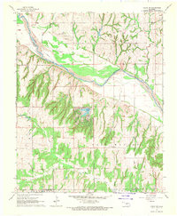
1967 Map of Fort Reno SW
USGS Topo · Published 1969About this map
The Chicago Rock Island and Pacific railroad cuts across this Central Oklahoma landscape, following the southern banks of the North Canadian River near the town of Calumet. This late 1960s survey illustrates a region defined by agricultural sections and the emerging petroleum industry, as evidenced by numerous gas wells scattered across the township lines. The terrain transitions from the river valley in the north to the dissected breaks of Tall Bear Canyon in the south, where the local school system is represented by Maple Sch. Rural life and local history are anchored by landmarks such as the Community Hall in the northwest and spiritual centers like Red Rock Ch. Near the settlement of Karns, the map preserves the locations of early local burial grounds including Sunny Hill Cem and Calumet Cem, providing a detailed record of the community's ancestral footprint.
Find a feature on this map
25 named features on this map. Tap any name to fly to it.
Don’t see what you’re looking for? This feature index may not catch every label — zoom into the map to look around manually.
Map Details
Editions of this 1967 Fort Reno SW Map
This is the sole edition of this map. No revisions or reprints were ever made.
Other maps of this area

1893 · Fort Reno
USGS Topo · 1:62,500

1893 · Buggy Creek
USGS Topo · 1:62,500

1941 · Fort Reno
USGS Topo · 1:62,500

1942 · Fort Reno
USGS Topo · 1:62,500

1942 · Geary
USGS Topo · 1:62,500

1949 · Fort Reno
USGS Topo · 1:62,500

1951 · Binger
USGS Topo · 1:62,500

1955 · Clinton
USGS Topo · 1:250,000

1957 · Clinton
USGS Topo · 1:250,000
1967 · Cogar NW
USGS Topo · 1:24,000