1980s Maps of Caddo County, Oklahoma
Explore 8 historic maps of Caddo County from the 1980s. These maps offer a rare glimpse into what life looked like during the 1980s — showing old roads, neighborhoods, homes, and landmarks that have changed or disappeared over time.
Whether you're researching your family's past, planning a metal detecting trip, or studying how Caddo County's landscape evolved across the 1980s, these high-resolution maps are a powerful tool for exploring the history of this region.
- Focus on a specific era: All maps on this page are from the 1980s, giving you a focused view of this time period.
- See what’s changed: Compare century-old streets, trails, and buildings to today's modern landscape using overlays and satellite layers.
- Research with precision: Use these maps for genealogy, historical research, land use analysis, or educational projects.
- View, download, or print: Maps are fully viewable online in high resolution, and can be downloaded or printed for your own records.
Start exploring Caddo County's history through authentic maps from the 1980s. This is your window into the past.
Caddo County, OK maps
(8)- 1981 Map of Lawton
 1981 Lawton1981 Print · USGSSouthwestern Oklahoma in the early eighties shows a landscape shaped by military history and the rising peaks of the Wichitas. Researchers can trace the boundaries of the Fort Sill Military Reservation and locate early settlements like Meers, Chattanooga, and Richards Spur.
 - 1984 Map of Eakly, 1985 Print
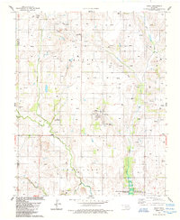 1984 Eakly1985 Print · USGSCaddo County's agricultural and water-management landscape comes into focus here in the mid-1980s. Local researchers can trace rural life through sites like Fairview Ch, private airfields like the Wheeler Landing Strip, and the early footprint of the Fort Cobb Reservoir.
 - 1984 Map of Carnegie, 1985 Print
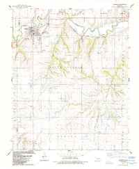 1984 Carnegie1985 Print · USGSCaddo County's agricultural and energy landscape comes alive in this mid-1980s survey of the Carnegie area. Researchers can trace the C R I & P railroad line and locate local landmarks such as Botone Memorial Ch and Carnegie Cem.
 - 1984 Map of Eakly NE, 1985 Print
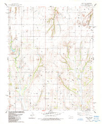 1984 Eakly NE1985 Print · USGSCaddo County in the mid-1980s reveals a rural Oklahoma landscape shaped by the energy industry and rugged landmarks. Genealogists and historians can trace the foundations of local communities at Sickles, Mt Zion Ch, and the family plots of Mound Valley Cem.
 - 1984 Map of Alfalfa, 1985 Print
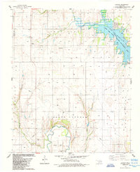 1984 Alfalfa1985 Print · USGSIn the mid-1980s, the plains of Caddo County were defined by the waters of the Fort Cobb Reservoir and the rural community of Alfalfa. Genealogists and researchers can locate old landmarks like the Alfalfa Sch, Daugamah Cem, and the meandering path of the Washita River.
 - 1985 Map of Hydro
 1985 Hydro1985 Print · USGSHydro and its surrounding Caddo County ranch lands are detailed in the mid-1980s, showcasing the intersection of energy production and rural life. Researchers can locate the Townhall and Hydro Cem, or trace the Farmrail corridor through the hills of Mound Valley.
 - 1985 Map of Watonga
 1985 Watonga1985 Print · USGSCentral Oklahoma in the mid-eighties shows a robust network of river-valley settlements and rural rail lines. Genealogists and historians can trace the footprint of Southwestern State College, the historic Fort Reno, and family-named landmarks like Dead Women Crossing.2 unique versions available
 - 1986 Map of Anadarko
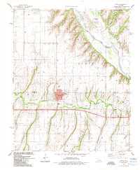
 1986 Anadarko1986 Print · USGSThe Oklahoma plains around Anadarko are captured in the mid-1980s, showing the intersection of rail history and tribal heritage. Genealogists and historians can trace the Indian Treaty Boundary or locate old rail stops along the Burlington Northern Railroad and Atchison, Topeka and Santa Fe Railway.2 unique versions available
End of results
Showing maps 1-8 of 8
Top cities of Caddo County
- Anadarko historical maps
- Hinton historical maps
- Carnegie historical maps
- Apache historical maps
- Cyril historical maps
- Fort Cobb historical maps
See more
Frequently asked questions
- What are the different types of historical maps available for Caddo County?
- What is the oldest map of Caddo County?
- Where can I purchase historical maps of Caddo County for my home or office?
- Where can I download high-res historical maps of Caddo County?
- Are there historical topographic maps available for Caddo County?
- Is there historical aerial imagery available for Caddo County?
- Where are historical maps of Caddo County sourced from?