1950s Maps of Coal County, Oklahoma
Explore 9 historic maps of Coal County from the 1950s. These maps offer a rare glimpse into what life looked like during the 1950s — showing old roads, neighborhoods, homes, and landmarks that have changed or disappeared over time.
Whether you're researching your family's past, planning a metal detecting trip, or studying how Coal County's landscape evolved across the 1950s, these high-resolution maps are a powerful tool for exploring the history of this region.
- Focus on a specific era: All maps on this page are from the 1950s, giving you a focused view of this time period.
- See what’s changed: Compare century-old streets, trails, and buildings to today's modern landscape using overlays and satellite layers.
- Research with precision: Use these maps for genealogy, historical research, land use analysis, or educational projects.
- View, download, or print: Maps are fully viewable online in high resolution, and can be downloaded or printed for your own records.
Start exploring Coal County's history through authentic maps from the 1950s. This is your window into the past.
Coal County, OK maps
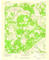
(9)- 1957 Map of Coalgate, 1958 Print
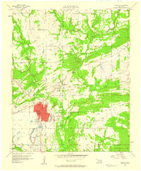 1957 Coalgate1958 Print · USGSCoalgate and the surrounding Coal County coalfields are captured here in the late fifties, showing the area's transition into a modern civic hub. Genealogists can trace family footprints at Calvary Cem, Sandmann Mine No 2, and the rural Lone Star Sch.3 unique versions available
 - 1957 Map of Lehigh, 1958 Print
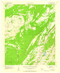
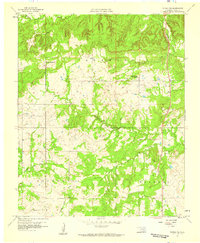
 1957 Lehigh1958 Print · USGSOklahoma's coal mining heartland comes alive in this mid-century survey of the Lehigh and Atoka area. Researchers can trace family history through the Lehigh Cem, locate old Strip Mine works, and find rural landmarks like Macedonia Sch.4 unique versions available
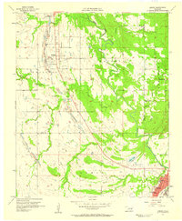
 - 1957 Map of Coalgate SE, 1958 Print
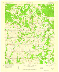
 1957 Coalgate SE1958 Print · USGSSoutheastern Oklahoma in the late fifties was a landscape of state-managed lands and busy rail corridors. Researchers can trace the lineage of rural communities through Cairo Cem and Flora or follow the heavy tracks of the Kansas City Southern.3 unique versions available
 - 1957 Map of Stonewall, 1959 Print
 1957 Stonewall1959 Print · USGSThe town of Stonewall and the surrounding Pontotoc County landscape are documented here in the late fifties during a period of steady growth. Researchers can trace family sites at Highland Cem or locate rural landmarks like Ahloso Sch and the Fish Hatchery.2 unique versions available
 - 1957 Map of Centrahoma, 1959 Print
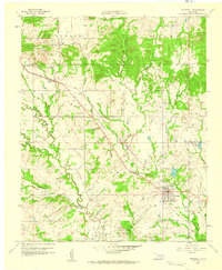
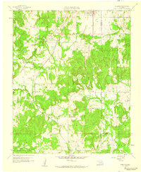
 1957 Centrahoma1959 Print · USGSOklahoma's coal and oil country is captured here in the late fifties, centered on the community of Centrahoma. Genealogists and historians can trace the locations of the Round Lake Cem, the Hazelton Mine, and the Oak Grove Sch (Abandoned).3 unique versions available
 - 1957 Map of Tupelo NE, 1959 Print
 1957 Tupelo NE1959 Print · USGSCoal County ranching and rural life are documented here in the late fifties, centered on the Muddy Boggy Creek drainage. Genealogists and historians can locate the Boiling Springs Ch, Glass Cem, and the old ranch at Diamond Bar Ranch.
 - 1957 Map of Ardmore, 1968 Print
 1957 Ardmore1968 Print · USGSSouth-central Oklahoma in the late fifties was a landscape of rising reservoir waters and expanding rail lines. Genealogists and historians can trace the foundations of Ardmore and Duncan or locate early recreation sites at Platt National Park and Lake Murray State Park.3 unique versions available
 - 1958 Map of Lula, 1959 Print
 1958 Lula1959 Print · USGSCoal County prairie life in the late fifties centered on small rail-side settlements and rural parishes. Family historians can trace church communities at Rocky Point Ch and locate burial sites like Lula Cem along the Kansas Oklahoma and Gulf line.3 unique versions available
 - 1958 Map of Steedman, 1959 Print
 1958 Steedman1959 Print · USGSPontotoc and Hughes counties appear here in the late fifties as a landscape of oil production and quiet rural communities. Researchers can trace the Old Indian Boundary and locate family landmarks like Black Rock Cem and Dawson Chapel.2 unique versions available
End of results
Showing maps 1-9 of 9
Top cities of Coal County
- Coalgate historical maps
- Tupelo historical maps
- Lehigh historical maps
- Phillips historical maps
- Centrahoma historical maps
Frequently asked questions
- What are the different types of historical maps available for Coal County?
- What is the oldest map of Coal County?
- Where can I purchase historical maps of Coal County for my home or office?
- Where can I download high-res historical maps of Coal County?
- Are there historical topographic maps available for Coal County?
- Is there historical aerial imagery available for Coal County?
- Where are historical maps of Coal County sourced from?