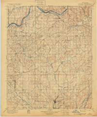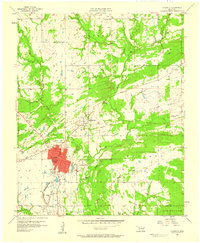
1957 Map of Coalgate
USGS Topo · Published 1958About this map
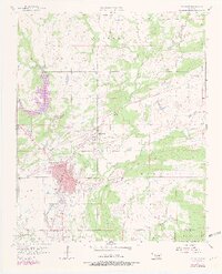
Coalgate serves as the primary urban center for this mid-century survey, its red-tinted grid of streets housing essential civic infrastructure like Hurley Hospital, the High Sch, and Emerson Sch. The landscape is defined by the winding course of Muddy Boggy Creek and its tributaries, which carve through the townships of Haskell and Hanraty. The region's industrial past is clearly marked by the presence of Sandmann Mine No 2 and Mine No 21, located northeast of the main town near Cottonwood. Small rural communities and landmarks like Cairo and Phillips dot the map, while numerous cemeteries, including Calvary Cem and Ott Cem, provide valuable points of interest for genealogists tracing family roots in Coal County. The dense network of creeks, including Coal Creek and Caney Creek, illustrates a terrain deeply connected to its natural waterways and mineral resources during the late 1950s.
Find a feature on this map
26 named features on this map. Tap any name to fly to it.
Don’t see what you’re looking for? This feature index may not catch every label — zoom into the map to look around manually.
Map Details
Editions of this 1957 Coalgate Map
3 editions found
Historical Maps of Coalgate Through Time
9 maps found