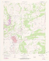
1957 Map of Coalgate
USGS Topo · Published 1979About this map
Muddy Boggy Creek and its many tributaries, including Caney Creek and Coal Creek, define the drainage patterns of this Coal County landscape during the late 1950s. The regional economy is evidenced by the Sandmann Mine No 2 and Mine No 21, while the development of the Coalgate area includes civic infrastructure like the Hurley Hospital, the Emerson Sch, and a dedicated Landing Strip. Small outlying settlements such as Cottonwood and Phillips are well-defined, alongside rural education centers like Lone Star Sch. The map reveals a high density of burial grounds for local genealogy research, including Ott Cem, Woodman Cem, and Calvary Cem. Specialized facilities such as the Fish Hatcheries near the western boundary suggest a mix of industrial mining and managed natural resources.
Find a feature on this map
29 named features on this map. Tap any name to fly to it.
Don’t see what you’re looking for? This feature index may not catch every label — zoom into the map to look around manually.
Map Details
Editions of this 1957 Coalgate Map
3 editions found
Other maps of this area

1896 · Coalgate
USGS Topo · 1:125,000

1899 · Coalgate
USGS Topo · 1:125,000

1899 · Atoka
USGS Topo · 1:125,000

1900 · Atoka
USGS Topo · 1:125,000

1900 · Coalgate
USGS Topo · 1:125,000

1956 · Stringtown
USGS Topo · 1:24,000

1957 · Coalgate
USGS Topo · 1:24,000

1957 · Lehigh
USGS Topo · 1:24,000

1957 · Coalgate SE
USGS Topo · 1:24,000

1957 · Centrahoma
USGS Topo · 1:24,000